
North Warwickshire is a local government district with borough status in Warwickshire, England. The borough includes the two towns of Atherstone and Coleshill, and the large villages of Hartshill, Kingsbury, Mancetter, Polesworth and Water Orton along with smaller villages and surrounding rural areas.

Bulkington is a large village and former civil parish near Bedworth, in the Nuneaton and Bedworth district of Warwickshire, England. In the 2011 census the ward had a population of 6,146 decreasing slightly to 6,080 at the 2021 census. It is located around 6 miles (10 km) northeast of Coventry, just south of the town of Nuneaton, east of Bedworth and 5 miles (8 km) southwest of Hinckley. Despite historically having stronger links with Bedworth, Bulkington forms part of the Nuneaton Urban Area. Bulkington was mentioned in the Domesday Book as Bochintone, meaning "estate associated with a man called Bulca".

Bere Regis is a village and civil parish in Dorset, England, situated 6 miles (9.7 km) north-west of Wareham. In the 2011 census the civil parish had a population of 1,745.

Barby is a village and civil parish about 5 miles (8 km) north of Daventry in Northamptonshire, England. The 2011 Census recorded the parish population as 2,336. Barby is located right off the M45 motorway a short spur from the M1 motorway to the A45 Trunk Road.
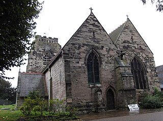
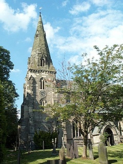
Polesworth is a large village and civil parish in the North Warwickshire district of Warwickshire, England. It is situated close to the northern tip of Warwickshire, adjacent to the border with Staffordshire. It is 3 miles (5 km) east of Tamworth, and is 4.5 miles (7 km) northwest of Atherstone.

Wellesbourne is a large village in the civil parish of Wellesbourne and Walton, in the county of Warwickshire, in the West Midlands region of England. In the 2021 census the parish had a population of 7,283, a significant increase from 5,849 In the 2011 census. The civil parish was renamed from Wellesbourne to Wellesbourne and Walton on 1 April 2014.

North Warwickshire and Bedworth is a constituency represented in the House of Commons of the UK Parliament.

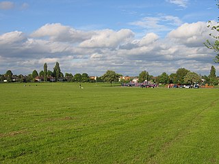
Great Alne is a small village in Warwickshire, England, 7 miles (11 km) north-west of Stratford-upon-Avon, 3 miles (4.8 km) north-east of Alcester and 15 miles (24 km) from Warwick, on the road to Wootton Wawen. It takes its name from the River Alne and was first chronicled in the charter of King Ethelbald (723–737). In 1969 Warwickshire County Council designated part of Great Alne as a Conservation Area, including most of the village east of the Memorial Hall and twelve listed buildings of local architectural and historical value. At the 2001 Census the population was 587.

Waverton is a village and civil parish on the outskirts of Chester in the unitary authority of Cheshire West and Chester and the ceremonial county of Cheshire, England. It lies about 3 miles (4.8 km) south-east of Chester High Cross, 19 miles (31 km) south of Liverpool and 33 miles (53 km) south west of Manchester. It is almost continuous with the village of Rowton to the north west and that in turn is almost continuous with Christleton. According to the 2011 Census, the population of the parish was 1,587.

Newton Regis is a village and civil parish in the North Warwickshire district of Warwickshire, England. It has a population of 599 at the 2011 Census.
Austrey is a village and civil parish in the North Warwickshire District of Warwickshire, England.

Baxterley is a small village and civil parish in the North Warwickshire district of Warwickshire in England. According to the 2001 Census, it had a population of 335, reducing to 328 at the 2011 Census. The village is about two miles west of Atherstone and is home to Jaguar Land Rover's national distribution centre.
Dordon is a village and civil parish in the North Warwickshire district of the county of Warwickshire in England and close to the border with Staffordshire. The village is located on the A5 national route and is contiguous with the larger village of Polesworth. Other nearby places include Tamworth, Atherstone, Grendon, Wood End Village, Baddesley Ensor and Nuneaton. In 2001 the population for the parish of Dordon was 3,225, reducing slightly to 3,215 at the 2011 census.

Newton-with-Scales is a village and former civil parish, now in the parish of Newton-with-Clifton, in the Fylde district, in the county of Lancashire, England. It is situated on the A583 road, 5 miles (8 km) from Preston and 11 miles (18 km) from Blackpool, in the. It has a park situated on School Lane, a restaurant / pub called the Bell and Bottle, a primary school called Newton Bluecoats, a shop called The convenience store which also has a Post Office. On the main road out of the village you will also find a Petrol Station and an Indian Restaurant called Ali Raj.
Piccadilly is a small village in the North Warwickshire district of the county of Warwickshire in England. It is located near to the larger village of Kingsbury, and is four miles south of Tamworth.

Shuttington is a village and civil parish in North Warwickshire, England, situated north-east of Tamworth, Staffordshire. In the 2001 census, the parish, which also includes Alvecote, had a population of 563, decreasing to 536 at the 2011 census. The River Anker flows through the parish, with Shuttington north-east of the river, and Alvecote south of it. The West Coast Main Line passes through Alvecote, with the Coventry Canal parallel to it and a marina south of the canal. Most of the parish is rural, including the village of Shuttington, although there was colliery alongside the railway at Alvecote.
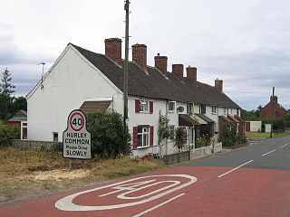
Hurley Common is a village in North Warwickshire, England, between Wood End and Hurley, it consists of several houses and 2 Farms, Hurley common does not have its own Parish Church so it is technically a hamlet. Population details for the 2011 Census can be found under Kingsbury.
Highter's Heath is a district and ward lying on the southern boundary of the city of Birmingham, UK. The district of Highter's Heath lies immediately east of the Maypole. The first recorded use of the name dates from 1495 as Heyters Heath, however today the name is not one that is particularly in widespread use, indeed only three signposted references to the name exist, when entering the city along Maypole Lane, when entering the city from the bottom of Highters Heath Lane and in Major's Green.
