Shuttington

Last updated

Shuttington
St Matthew's Church at Shuttington.jpg
Saint Matthew parish church
Warwickshire UK location map.svg
Red pog.svg
Shuttington
Location within Warwickshire
Population536 (2011)
Civil parish
  • Shuttington
District
Shire county
Region
Country England
Sovereign state United Kingdom
Post town TAMWORTH
Postcode district B79
Dialling code 01827
Police Warwickshire
Fire Warwickshire
Ambulance West Midlands
UK Parliament
List of places
UK
England
Warwickshire
52°38′38″N1°37′19″W / 52.644°N 1.622°W / 52.644; -1.622 Coordinates: 52°38′38″N1°37′19″W / 52.644°N 1.622°W / 52.644; -1.622

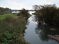
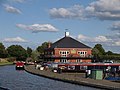
Shuttington is a village and civil parish in North Warwickshire, England, situated north-east of Tamworth, Staffordshire. [1] In the 2001 census, the parish, which also includes Alvecote, had a population of 563, [2] decreasing to 536 at the 2011 census. [3] The River Anker flows through the parish, with Shuttington north-east of the river, and Alvecote south of it. The West Coast Main Line passes through Alvecote, with the Coventry Canal parallel to it and a marina south of the canal. Most of the parish is rural, including the village of Shuttington, although there was colliery alongside the railway at Alvecote.

Contents

A series of pools situated along the river, on the boundary with Tamworth, were created as a result of subsidence caused by coal mining in the area. The pools, which attract a wide variety of bird species, have been designated as a Site of Special Scientific Interest. [4] The parish church of St. Matthew, situated on the edge of Shuttington village, is a small building, with a nave dating from the 12th century. [5] The Wolferstan Arms pub is on Main Road in the village. [6] There is also the Samuel Barlow pub, situated on the canal at Alvecote.

Local government

Shuttington is in the district of North Warwickshire, and is part of the Newton Regis and Warton ward. The ward, which also contains Alvecote, Austrey, Newton Regis, No Man's Heath, Seckington and Warton, has a population of 3,625 and is represented by two councillors. [7] [8] Shuttington had formerly been in Tamworth Rural District, which was created in 1894, until the district was abolished in 1965. The parish was transferred to Atherstone Rural District, which became part of North Warwickshire in the 1974 reorganisation of local government. [9]

Notable people

Related Research Articles

North Warwickshire Borough & Non-metropolitan district in England

North Warwickshire is a local government district with borough status in the ceremonial county of Warwickshire, West Midlands, England. Outlying settlements in the borough include the two towns of Atherstone and Coleshill. Notable villages in the borough include Dordon, Polesworth, Kingsbury, Water Orton and Shustoke.

Polesworth Human settlement in England

Polesworth is a large village and civil parish in the North Warwickshire district of Warwickshire, England. Polesworth is situated close to the northern tip of Warwickshire, adjacent to the border with Staffordshire. It is 3 miles (5 km) east of Tamworth, and is 5 miles (8 km) north-west of Atherstone. The border with Derbyshire is 6 miles (10 km) to the north and the River Anker runs through the village. In the 2011 census the civil parish of Polesworth had a population of 8,423, inclusive of the contiguous sub-villages of Birchmoor, St Helena, and Hall End directly to the south, and Warton to the East. The built-up area of Polesworth which includes the adjoining village of Dordon to the south had a population of 9,645 in 2011.

River Anker River in England

The River Anker is a river in England that flows through the centre of Nuneaton. It is a major tributary of the River Tame, which it joins in Tamworth. The name of the river derives from an old British term for winding river. From source to river mouth at Tamworth is 50 kilometres (31 mi).

Statfold Human settlement in England

Statfold is a former village in Staffordshire, England, about 3 miles (5 km) north-east of Tamworth. Population details as taken at the 2011 census can be found under Clifton Campville. These days little remains of the village itself, but the Norman parish church, and the Tudor manor house of Statfold Hall still exist, as do a few scattered farms and houses.

Newton Regis Human settlement in England

Newton Regis is a village and civil parish in the North Warwickshire district of Warwickshire, England. It has a population of about 700, being measured as 599 at the 2011 Census.

Amington is a suburban village, parish and ward, in Staffordshire, England. Formerly a distinct village, it is now part of the Tamworth borough, with no gap between it and the neighbouring wards of Bolehall, Glascote, Glascote Heath and Stonydelph.

Austrey, Warwickshire Human settlement in England

Austrey is a village and civil parish in the North Warwickshire District of Warwickshire, England. and the village lies at the northern extremity of the County.

Witherley Village in Leicestershire, England

Witherley is a village and civil parish in the Hinckley and Bosworth district of Leicestershire, England. The civil parish of Witherley includes Atterton, Fenny Drayton, and Ratcliffe Culey as well as the village of Witherley itself. The population of the civil parish at the 2011 census was 1,373.

Warton, Warwickshire

Warton is a village in the North Warwickshire district of Warwickshire, England. It is five miles east of Tamworth and four miles north-west of Atherstone, and is in the civil parish of Polesworth. Warton is a small village, which, being surrounded by rivers, may derive its name from Waverton. There is still a Waverton Avenue in the village, even though the street was actually constructed in the 1960s. The village has grown considerably since the 1960s, when its character was changed after an inflow of overspill families from Birmingham. Although small, the village has a pub, as well as a Working Men's Club. There is one shop – Maypole Stores, named after the Maypole that stood at the highest point of the village. In the 1980s, there were several shops, but all but one have now closed. Up until the late 1990s, there were two functional shops in the village, but the most northern one was converted into a residential property by its owner.

Wood End, Kingsbury, Warwickshire Human settlement in England

Wood End is an old mining village in North Warwickshire, England. It lies to the south east of Tamworth and close to the border with Staffordshire. It grew around the former Kingsbury Colliery but now it serves as a commuter village to Tamworth. It has a church, a primary school, a co-operative store, a working men's club and a village hall. The population of Wood End is 2,205, but from the 2011 Census has been included in Kingsbury, Warwickshire.

Warton, Lancaster Human settlement in England

Warton is a village, civil parish and electoral ward in the City of Lancaster in north Lancashire in the north-west of England, close to the boundary with Cumbria, with a population of around 2,000, measured at the 2011 Census to be 2,360. It is a village steeped in history; its earliest recording as a settlement is made in Domesday Book written in 1086. The nearest town to Warton is Carnforth, which was originally part of Warton parish. It has connections to the first President of the United States, George Washington: Washington's ancestor of seven generations, Lawrence Washington, is rumoured to have helped build the village church of St Oswald. The parish covers an area in excess of 11,000 acres (45 km2) and is predominantly rural. The parish of Warton had a population of 2,315 recorded in the 2001 census, and 2,360 in the 2011 census.

Burton Hastings Human settlement in England

Burton Hastings is a village and civil parish in the English county of Warwickshire.

Dordon Human settlement in England

Dordon is a village and civil parish in the North Warwickshire district of the county of Warwickshire in England and close to the border with Staffordshire. The village is located on the A5 and is adjacent to the larger village of Polesworth. Other nearby places include Tamworth, Atherstone, Grendon, Wood End Village, Baddesley Ensor and Nuneaton. In 2001 the population for the parish of Dordon was 3,225, reducing slightly to 3,215 at the 2011 census.

Hurley, Warwickshire Human settlement in England

Hurley is a village in the Kingsbury civil parish of North Warwickshire, England. Other nearby places include Wood End, Hurley Common, Coleshill, Water Orton, Curdworth, Atherstone and Tamworth. According to the 2001 Census the population of the Hurley and Wood End ward was 3,642. Over 99.5% of people (3,550) described themselves as White British with only 89 people from other ethnic groups. The most common distance travelled to work is 5–10 kilometres (3.1–6.2 mi), which is essentially to Tamworth, with the most common form of employment being manufacturing. The village has an almost exact 50:50 split of males and females, with a ratio of 1,822 to 1,820 respectively.

Alvecote Human settlement in England

Alvecote is a hamlet in the North Warwickshire district of Warwickshire, England, situated on the county border with Staffordshire. Other settlements nearby are Shuttington, Polesworth and the Tamworth district of Amington. Central Tamworth is approximately 3 miles west-southwest of Alvecote. Alvecote has a marina on the Coventry Canal with many facilities including boat repair, pumpout and a licensed bar. The West Coast Main Line runs through the settlement. The nearest railway station is Polesworth, though that station now only sees one westbound parliamentary train per day. Alvecote Priory is a ruined 12th century Benedictine monastery. The nearest existing church is in Shuttington.

Piccadilly is a small village in the North Warwickshire district of the county of Warwickshire in England. It is located near to the larger village of Kingsbury, and is four miles south of Tamworth.

Upton Warren Human settlement in England

Upton Warren is a village and civil parish in the Wychavon district, in Worcestershire, England. The village is situated just off the A38 road between Bromsgrove and Droitwich Spa, and on the River Salwarpe. In the 2001 census, the parish, which also contains the small hamlet of Cooksey Green, had a population of 291.

Hurley Common Human settlement in England

Hurley Common is a village in North Warwickshire, England, between Wood End and Hurley, it consists of several houses and 2 Farms, Hurley common does not have its own Parish Church so it is technically a hamlet. Population details for the 2011 Census can be found under Kingsbury.

Seckington Human settlement in England

Seckington is a village and civil parish in North Warwickshire, about 4 miles (6 km) northeast of Tamworth, Staffordshire. The B4593 road between Tamworth and Appleby Magna runs through the parish, passing about 100 yards (91 m) north of the village. Seckington shares a parish council with Newton Regis and No Man's Heath.

Grendon, Atherstone Human settlement in England

Grendon is a civil parish which includes both Old Grendon and New Grendon in North Warwickshire, England. Old Grendon is a village situated three miles (5 km) west of Atherstone and five miles (8 km) east of Tamworth centred on the A5. It lies on the north-western tip of Warwickshire, divided from Leicestershire by a small stream and by the River Anker. Also, Grendon has since enlarged and has a population of 1000.

References

  1. OS Explorer Map 232 : Nuneaton & Tamworth: (1:25 000) : ISBN   0 319 46404 0
  2. "2001 Census: Key Statistics: Parish Headcounts: Area: Shuttington CP (Parish)". Neighbourhood Statistics. Office for National Statistics . Retrieved 26 January 2009.
  3. "Civil Parish population 2011" . Retrieved 22 December 2015.
  4. "Alvecote Pools" (PDF). English Nature . Retrieved 26 January 2009.
  5. "'Parishes: Shuttington', A History of the County of Warwick: Volume 4: Hemlingford Hundred". British History Online. University of London & History of Parliament Trust. 1947. pp. 212–214. Retrieved 26 January 2009.
  6. "Wolferstan Arms". Marston's Inns and Taverns . Retrieved 26 January 2009.
  7. "2001 Census: Census Area Statistics: Population (UV01): Area: Newton Regis and Warton (Ward)". Neighbourhood Statistics. Office for National Statistics . Retrieved 26 January 2009.
  8. "Councillors by Ward: Newton Regis and Warton". North Warwickshire Borough Council. Retrieved 26 January 2008.
  9. "Shuttington AP/CP Warwickshire through time: Administrative history of Parish-level Unit: hierarchies, boundaries". A Vision of Britain through Time . University of Portsmouth & others. 2008. Retrieved 26 January 2009.

Commons-logo.svg Media related to Shuttington at Wikimedia Commons