
A dam is a barrier that stops or restricts the flow of surface water or underground streams. Reservoirs created by dams not only suppress floods but also provide water for activities such as irrigation, human consumption, industrial use, aquaculture, and navigability. Hydropower is often used in conjunction with dams to generate electricity. A dam can also be used to collect or store water which can be evenly distributed between locations. Dams generally serve the primary purpose of retaining water, while other structures such as floodgates or levees are used to manage or prevent water flow into specific land regions.

Kielder Water is a large man-made reservoir in Northumberland in North East England. It is the largest artificial lake in the United Kingdom by capacity of water and it is surrounded by Kielder Forest, one of the biggest man-made woodlands in Europe. The scheme was planned in the late 1960s to satisfy an expected rise in demand for water to support a booming UK industrial economy. But the decline of traditional heavy industry, together with more water-efficient industrial processes and better control of water supply leakage, served to undermine the original justification for the reservoir and the government-funded project has been criticised as a white elephant.

The Derwent Reservoir is a reservoir on the River Derwent, on the border between County Durham and Northumberland, in England. It is west of Consett. It is 3.5 miles (5.6 km) long) and covers an area of 4 km2 and has a maximum depth of 100 ft (30m) and when full, holds 11,000 million gallons (50,000,000m³).

Waskerley is a village in County Durham, England. It is situated six miles to the southwest of Consett and three miles southwest of Castleside and the A68. Stanhope in the Durham Dales is a further six miles to the southwest and the Derwent Reservoir and the village of Edmundbyers is approximately five miles to the north. The village of Muggleswick is three miles to the north.

Wyangala Dam is a major gated rock fill with clay core embankment and gravity dam with eight radial gates and a concrete chute spillway across the Lachlan River, located in the south-western slopes region of New South Wales, Australia. The dam's purpose includes flood mitigation, hydro-power, irrigation, water supply and conservation. The impounded reservoir is called Lake Wyangala.
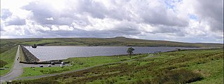
Burnhope Reservoir is a reservoir above the village of Wearhead, County Durham, England.
Balderhead Reservoir is a reservoir in Baldersdale, County Durham, England. It is one of a chain of three reservoirs on the River Balder, a tributary of the River Tees, which it joins at Cotherstone, about 5 miles (8 km) to the east. Balderhead Reservoir was commissioned by the Tees Valley and Cleveland Water Board (TVCWB) to increase water supply to Teesdale and Teesside.
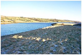
Hury Reservoir is a reservoir in County Durham, England situated in Baldersdale. The reservoir is located about four miles south of Middleton-in-Teesdale and about three miles west of Cotherstone. It supplies water for Teesdale and is owned by Northumbrian Water. It gets its name from the nearby village of Hury. It is almost adjoined to Blackton Reservoir to the immediate west. The dam 'bridges' the River Balder which flows in an easterly direction to meet the River Tees at Cotherstone. Hury Reservoir was under construction in 1891–92.
The O'Shannassy Reservoir is an Australian man-made water supply dammed reservoir. The 3.123 GL water store across the O'Shannassy River is located near the locality of McMahons Creek, approximately 80 kilometres (50 mi) east of Melbourne, Victoria. The dam that creates the impoundment is called the O'Shannassy Dam.

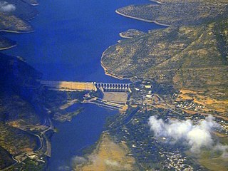
Idamalayar Dam is a multipurpose concrete gravity dam located at Ennakkal between Ayyampuzha and Bhoothathankettu in Ernakulam district of Kerala on the Idamalayar, a tributary of the Periyar River in Kerala, South India. The dam however extends east as far as Malakkappara. Completed in 1985, with a length of 373 metres (1,224 ft) and a height of 102.8 metres (337 ft), the dam created a multipurpose reservoir covering 28.3 km2 (10.9 sq mi) in the scenic hills of the Anamalais.
Northumbrian Water Limited is a water company in the United Kingdom, providing mains water and sewerage services in the English counties of Northumberland, Tyne and Wear, Durham and parts of North Yorkshire, and also supplying water as Essex and Suffolk Water. It is a wholly owned subsidiary of Northumbrian Water Group.

Tunstall Reservoir was a water supply storage reservoir completed in 1879, and now used solely to maintain minimum regulatory flows on the River Wear in northeast England. It is situated in the north Pennines of the United Kingdom, and lies 3.5 km north of the village of Wolsingham, in Weardale, County Durham. The earthen embankment dam, which impounds the reservoir, is recognized as the location where pressure grouting with cement grout was first utilized in 1876 by engineer Thomas Hawksley, to reduce leakage within the rock foundation under an earth dam. Pressure grouting has since become normal practice for construction and remediation at dams and related water resource projects.

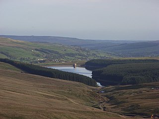
Smiddy Shaw Reservoir is one of a group of three reservoirs located on Muggleswick Common, County Durham, the others being Waskerley and Hisehope Reservoirs.

Hisehope Reservoir is the smallest of a group of three reservoirs located on Muggleswick Common, County Durham, the others being Waskerley and Smiddy Shaw Reservoirs.
The Kukule Ganga Dam is a 110 m (360 ft) gravity dam built across the Kukule River in Kalawana, Sri Lanka. The run-of-river dam feeds an underground hydroelectric power station located approximately 5 kilometres (3.1 mi) away, via tunnel.
The "Somasila Dam" is a dam constructed across the Penna River near Somasila, Nellore district, Andhra Pradesh, India. The reservoir impounded by the dam has a surface area of 212.28 km2 with live storage capacity of 1.994 km3 (1,616,562 acre⋅ft) or 75 tmcft.

Scaling Dam Reservoir is a freshwater man-made lake on the edge of the A171 road in North Yorkshire, England. The reservoir is near to the hamlet of Scaling from where it derives its name, and was built in 1958.

