Related Research Articles

A lock is a device used for raising and lowering boats, ships and other watercraft between stretches of water of different levels on river and canal waterways. The distinguishing feature of a lock is a fixed chamber in which the water level can be varied; whereas in a caisson lock, a boat lift, or on a canal inclined plane, it is the chamber itself that rises and falls.

The Canal du Midi is a 240 km (150 mi) long canal in Southern France. Originally named the Canal Royal en Languedoc and renamed by French revolutionaries to Canal du Midi in 1789, the canal is considered one of the greatest construction works of the 17th century.

The Smethwick Engine is a Watt steam engine made by Boulton and Watt, which was installed near Birmingham, England, and was brought into service in May 1779. Now at Thinktank, Birmingham Science Museum, it is the oldest working steam engine and the oldest working engine in the world.

The Canal Saint-Martin is a 4.6 km long canal in Paris, connecting the Canal de l'Ourcq to the river Seine. Nearly half its length, between the Rue du Faubourg du Temple and the Place de la Bastille, was covered in the mid-19th century to create wide boulevards and public spaces on the surface. The canal is drained and cleaned every 10–15 years, and it is always a source of fascination for Parisians to discover curiosities and even some treasures among the hundreds of tons of discarded objects.

Aike Beck or the Lockington Navigation was a stream in the East Riding of Yorkshire, England, which was constructed as a navigation in the late 18th century, and ceased to function as such in the 1850s. The water supply came from Bryan Mills Beck and Scorborough Beck, but in 1988, these were diverted to feed into Arram Beck, and most of the channel was filled in with material from the flood banks.

The lifts on the Canal du Centre are a series of four hydraulic boat lifts near the town of La Louvière in Belgium which are classified as a World Heritage Site by UNESCO. All four are located on the Canal du Centre in Belgium's historic sillon industriel industrial belt.
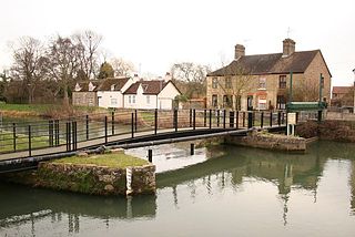
Stamford Canal, now disused, is one of the earliest post-Roman canals in England. It opened in 1670, around 100 years before the start of the Industrial Revolution which brought about the "golden age" for canals in Britain. Parts of the route can be traced on the ground, though only one lock survives intact. It was part of the Welland Navigation in Lincolnshire. First authorised in 1571, during the reign of Elizabeth I, construction did not start until 1664, under powers granted in 1620 and ratified by James I. It ran for 9.5 miles (15.3 km) from Stamford to Market Deeping and had 12 locks, two of which were on the river section at Deeping St James. No plans of its construction survive, although one of the locks was documented by a visiting water engineer in 1699. It contributed to the wealth of Stamford, allowing barley to be transported to the town for malting.

The Stourport Ring is a connected series of canals forming a circuit, or canal ring, around Worcestershire, The Black Country and Birmingham in The Midlands, England. The ring is formed from the River Severn, the Staffordshire and Worcestershire Canal, the Stourbridge Canal, the Dudley Canals, the Birmingham Canal Navigations and the Worcester and Birmingham Canal.
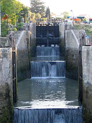
Fonseranes Locks are a flight of staircase locks on the Canal du Midi near Béziers.

The Walsall Canal is a narrow canal, seven miles (11 km) long, forming part of the Birmingham Canal Navigations, and passing around the western side of Walsall, West Midlands, England.

Pidcock's Canal was a canal in Gloucestershire, England, which connected ironworks at Upper Forge and Lower Forge, and also ran to an inlet from the River Severn called Lydney Pill. It was constructed from 1778 onwards, and there were three locks below Middle Forge. Following the construction of the Lydney Canal in 1813, the canal connected to that, rather than Lydney Pill, and it was disused after 1840, by which time a horse-drawn tramway had been built up the valley of The Lyd. The tramway was eventually relaid as a steam railway and is now preserved as the Dean Forest Railway. Most of the canal, colloquially called The Cut, still exists below Middle Forge.

The Grand Bassin is the largest body of open water along the Canal du Midi. It is in Castelnaudary, France and covers some 7 hectares. Once a scene of intense economic activity, it is now a major pleasure port used by tourist craft. It holds the water reserve for the four locks of Saint-Roche.

There are 91 working locks on the Canal du Midi along its 240-kilometre (150 mi) course from the Bassin du Thau on the Mediterranean coast to the junction with the Canal lateral a la Garonne in Toulouse. There are a further 13 locks on the 37-kilometre (23 mi) La Nouvelle branch which runs through Narbonne to the Mediterranean at Port-la-Nouvelle. The locks are all under the management of the French navigation authority, Voies navigables de France.

The Bradley Branch or Bradley Locks Branch was a short canal of the Birmingham Canal Navigations in the West Midlands, England. Completed in 1849, it included nine locks, and had a number of basins which enabled it to service local collieries and industrial sites. The locks were unusual, as they had a single gate at both ends, rather than double gates at the bottom end. The route closed in the 1950s, and the top seven locks were covered over and landscaped.

The Bassin de Saint-Ferréol was created as the result of a large earth dam across the mouth of the valley of Laudot stream at St. Ferréol in the Montagne Noire. It was originally proposed by Chevalier de Clerville and accepted by Pierre Paul Riquet as an integral part of the Canal du Midi. Riquet needed to provide a sufficient water reservoir to allow the locks to function year round, even in the dry summer season. The dam was begun on 15 April 1667 and was completed in four years. It was the first dam built specifically to supply water to a navigable canal and was by far the greatest single work of civil engineering undertaken during the building of the Canal du Midi.

The Agde Round Lock is a canal lock on the Canal du Midi that connects to the Hérault River in Agde, France. It is almost unique because it is round, which allows a boat to turn around, and the fact that it has three sets of lock gates, each with a different water level. It was built in 1676 of volcanic stone and was originally 29.20 m in diameter, 5.20 m deep.

The Seuil de Naurouze, or Col de Naurouze, is the highest point of the Canal du Midi in southern France. It is the watershed point identified by Pierre-Paul Riquet when he designed and built the canal. Water falling on the western side of this point flows to the Atlantic Ocean and on the eastern side to the Mediterranean Sea. It is on the border of the department of Haute-Garonne and the department of the Aude.

The rigole de la montagne was an important facet of the Canal du Midi, engineered by Pierre-Paul Riquet in southern France. The canal itself was built during 1666-1681. A critical aspect of the Canal du Midi was the supply of sufficient water to feed the canal. Each boat traversing its length would require a large quantity of water in the locks in order to climb or descend.
The Bassin de Lampy was created during 1777 and 1781 when a dam was placed on the Lampy Valley in the Aude department in south-central France. The reservoir provides a source of water for the Canal du Midi. It was originally proposed in 1665 by the commission created by Louis XIV of France to evaluate Pierre-Paul Riquet's plan for the canal enterprise.

Aqueducts on the Canal du Midi allow the canal to intersect and cross over natural streams. There are two exceptions, the first is the Herbettes Aqueduct where it crosses a four-lane highway in Toulouse. Another exception is where it intersections with the Libron river and the crossing is accomplished via the Ouvrages du Libron.
References
- 1 2 3 4 Midi Camargue Waterways Guide 7. Editions Du Breil. ISBN 2-913120-04-0.
- ↑ Vois Navigables Canaux du Midi. Editions De L'Ecluse. 2008. ISBN 978-2-916919-09-6.