
Hydrology is the scientific study of the movement, distribution, and management of water on Earth and other planets, including the water cycle, water resources, and drainage basin sustainability. A practitioner of hydrology is called a hydrologist. Hydrologists are scientists studying earth or environmental science, civil or environmental engineering, and physical geography. Using various analytical methods and scientific techniques, they collect and analyze data to help solve water related problems such as environmental preservation, natural disasters, and water management.

A drainage basin is an area of land where all flowing surface water converges to a single point, such as a river mouth, or flows into another body of water, such as a lake or ocean. A basin is separated from adjacent basins by a perimeter, the drainage divide, made up of a succession of elevated features, such as ridges and hills. A basin may consist of smaller basins that merge at river confluences, forming a hierarchical pattern.
A geocode is a code that represents a geographic entity. It is a unique identifier of the entity, to distinguish it from others in a finite set of geographic entities. In general the geocode is a human-readable and short identifier.

The Sava is a river in Central and Southeast Europe, a right-bank and the longest tributary of the Danube. It flows through Slovenia, Croatia and along its border with Bosnia and Herzegovina, and finally through Serbia, feeding into the Danube in its capital, Belgrade. The Sava forms the main northern limit of the Balkan Peninsula, and the southern edge of the Pannonian Plain.

The Una is a border river between Bosnia and Herzegovina and Croatia and a right tributary of the Sava river. It is part of the Black Sea drainage basin, and its watershed has a size of 10,200 km2 (3,900 sq mi), of which 8,080 km2 (3,120 sq mi) belongs to Bosnia and Herzegovina, and 2,120 km2 (820 sq mi) to Croatia. The total length of the river is 212 km (132 mi). The source of the river is located near the village of Donja Suvaja in Croatia, and its mouth is located near the village of Jasenovac, on the border with Bosnia. The largest right tributaries are the Krka, Unac, Krušnica and Sana rivers, and the largest left tributary is the Klokot river. Its longest headwater is the Unac river. The largest and most important city located on the river is Bihać. Other, important cities and towns are Bosanska Krupa, Bosanski Novi and Bosanska Kostajnica. The river is characterized by a multitude of waterfalls, rapids, karst springs and relatively untouched nature. A large part of the upper river is part of the Una National Park.

The Elz is a river in Baden-Württemberg, Germany, a right tributary of the Rhine. It rises in the Black Forest, near the source of the Breg. The Elz flows through Elzach, Waldkirch and Emmendingen before reaching the Rhine near Lahr. Its length is approx. 121 km (75 mi).
The Trebišnjica is a river in Bosnia and Herzegovina, and the right tributary of the Neretva. Before it was utilized for hydro exploitation via various hydrotechnical interventions and systems with different purposes, Trebišnjica used to be a sinking river, rising and sinking through its course before resurfacing at various places from the Neretva river below the Čapljina to the Adriatic coast, and along the coast from the Neretva Delta to Sutorina.
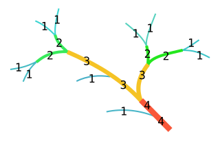
In mathematics, the Strahler number or Horton–Strahler number of a mathematical tree is a numerical measure of its branching complexity.

A perennial stream is a stream that has continuous flow of surface water throughout the year in at least parts of its catchment during seasons of normal rainfall, as opposed to one whose flow is intermittent. In the absence of irregular, prolonged or extreme drought, a perennial stream is a watercourse, or segment, element or emerging body of water which continually delivers groundwater. For example, an artificial disruption of stream, variability in flow or stream selection associated with the activity in hydropower installations, do not affect this status. Perennial streams do not include stagnant water, reservoirs, cutoff lakes and ponds that persist throughout the year. All other streams, or parts of them, should be considered seasonal rivers or lakes. The stream can cycle from intermittent to perpetual through multiple iterations.

In hydrology, a mainstem is "the primary downstream segment of a river, as contrasted to its tributaries". The mainstem extends all the way from one specific headwater to the outlet of the river, although there are multiple ways to determine which headwater is the source of the mainstem. Water enters the mainstem from the river's drainage basin, the land area through which the mainstem and its tributaries flow. A drainage basin may also be referred to as a watershed or catchment.
A hydrological code or hydrologic unit code is a sequence of numbers or letters that identify a hydrological unit or feature, such as a river, river reach, lake, or area like a drainage basin or catchment.
The stream order or waterbody order is a positive whole number used in geomorphology and hydrology to indicate the level of branching in a river system.

A stream is a continuous body of surface water flowing within the bed and banks of a channel. Depending on its location or certain characteristics, a stream may be referred to by a variety of local or regional names. Long, large streams are usually called rivers, while smaller, less voluminous and more intermittent streams are known as streamlets, brooks or creeks.
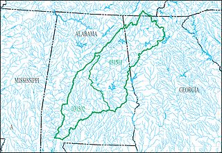
The Alabama-Coosa-Tallapoosa River Basin is a drainage basin (watershed) in the Southeastern United States. The basin is located mainly in eastern Alabama, but also goes includes a small part of Georgia. This area is classified as a sub-region by the USGS hydrological code system.
The Gewässerkennzahl or "waterbody index number/waterbody number" is an identifier with which all watercourses in Germany are numbered, together with their catchments and precipitation areas. It is also referred to as a Gebietskennzahl or "basin number". A Gewässerkennzahl may have up to 13 figures. Basins normally are only defined up to seven figures. For a more detailed subdivision, the Gewässerkennzahl may be enlarged by ten more figures. Only that enlarged version is called Fließgewässerkennziffer. The Gewässerkennzahlen are defined by the environment offices of the states.
The Pfafstetter Coding System is a hierarchical method of hydrologically coding river basins. It was developed by the Brazilian engineer Otto Pfafstetter in 1989. It is designed such that topological information is embedded in the code, which makes it easy to determine whether an event in one river basin will affect another by direct examination of their codes.

The Ribnik is a river in western Bosnia and Herzegovina. It is a headwater tributary of the Sana, which it meat at Strane and Velije hamlets of the Gornji Ribnik village, 17 km below the Sana's own source springs, bringing in a large amounts of water to the still young Sana. It is among shortest of the Sana tributaries but at the same time among largest by the volume it discharges into the receiving Sana. The Ribnik is well known as a prime fly fishing fishery and is popular among anglers throughout the world.

For the use of hydrologists, ecologists, and water-resource managers in the study of surface water flows in the United States, the United States Geological Survey created a hierarchical system of hydrologic units.

Northern Mojave–Mono Lake water resource subregion is one of 10 water resource subregions within the California water resource region and is one of 222 water resource subregions in the federally organized United States hydrologic unit system.