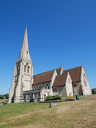
Blackheath is an area in Southeast London, straddling the border of the Royal Borough of Greenwich and the London Borough of Lewisham. Historically within the county of Kent, it is located 1-mile (1.6 km) northeast of Lewisham, 1.5 miles (2.4 km) south of Greenwich and 6.4 miles (10.3 km) southeast of Charing Cross, the traditional centre of London.

Catford is a district in south east London, England, and the administrative centre of the London Borough of Lewisham. It is southwest of Lewisham itself, mostly in the Rushey Green and Catford South wards. The population of Catford, including Bellingham, was 44,905 in 2011.

Crofton Park is a mainly residential suburb and electoral ward in the London Borough of Lewisham.

Crystal Palace is a leafy and hilly area in South London, named after the Crystal Palace Exhibition building which stood in the area from 1854, until it was destroyed by fire in 1936. About 7 miles (11 km) southeast of Charing Cross, it includes one of the highest points in London, at 367 feet (112 m), offering views over the capital.

Sydenham is a district of south-east London, England, which is shared between the London boroughs of Lewisham, Bromley and Southwark. Prior to the creation of the County of London in 1889, Sydenham was located in Kent, bordering Surrey. Historically, the area was very affluent, with the Crystal Palace being relocated to Sydenham Hill in 1854. Today, Sydenham is a diverse area, with a population of 28,378 and borders Forest Hill, Dulwich, Crystal Palace, Penge, Beckenham, Catford and Bellingham.
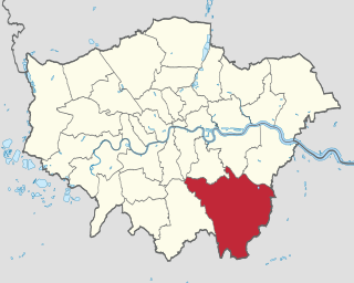
The London Borough of Bromley is the largest and southeasternmost of the London boroughs that make up Greater London, bordering the county of Kent, which most of Bromley was part of before 1965. The borough's population in the 2021 census was 329,991. It is named after Bromley, its principal town; other major towns are Penge, Hayes, West Wickham, Chislehurst, Beckenham and Orpington. The local authority is Bromley London Borough Council.

Lewisham is a London borough in south-east London; it forms part of Inner London. The principal settlement of the borough is Lewisham. The local authority is Lewisham London Borough Council, based in Catford. The Prime Meridian passes through Lewisham. Blackheath, Goldsmiths, University of London and Millwall F.C. are located within the borough.

Lewisham is an area of southeast London, England, six miles south of Charing Cross. It is the principal area of the London Borough of Lewisham, and was within the historic county of Kent until 1889. It is identified in the London Plan as one of 35 major centres in Greater London, with a large shopping centre and street market. Lewisham had a population of 60,573 in 2011.

The River Ravensbourne is a tributary of the River Thames in south London, England. It flows into the tidal River Thames at Deptford, where its tidal reach is known as Deptford Creek.

Grove Park is a district of South East London, England within the London Borough of Lewisham. It is located north east of Bromley and south east of Lewisham.

Lower Sydenham railway station is located on the boundary of the London Borough of Bromley and the London Borough of Lewisham in south-east London. It is 9 miles 2 chains (14.5 km) measured from London Charing Cross.
Walking is a popular recreational activity in London, despite traffic congestion. There are many streets that provide interesting walks, especially within historic central London, In addition there are attractive commons, parks, canals, and disused railway tracks that provide space for walks. This includes Wimbledon Common, Epping Forest, Hampstead Heath, and the eight Royal Parks: Hyde Park, Regent's Park, Richmond Park, etc. In recent years access to canals and rivers, including the Regent's Canal, and the River Thames has been greatly improved, and as well a number of long-distance walking routes have been created that link green spaces.

The South East London Green Chain, also known as the Green Chain Walk, is a linked system of open spaces between the River Thames and Crystal Palace Park in London, England. In 1977 four London boroughs and the Greater London Council created this Green Chain of 300 open spaces to protect them from building activity. The four London boroughs are Bexley, Bromley, Lewisham and Greenwich. More recently it has been extended to include sections in Southwark. Many parts of the system are also part of the Capital Ring route.

Lewisham parks and open spaces are part of the "green lung" of London and include a diverse range of sites, from small urban parks and gardens to one of the most historic natural landscapes in Greater London at Blackheath. While overall control rests with London Borough of Lewisham, management of borough-owned parks and their facilities is contracted out to Glendale Grounds Management.

Lewisham West and Penge is a constituency in Greater London created in 2010 and represented in the House of Commons of the UK Parliament since 2017 by Ellie Reeves of the Labour Party.

Horn Park is an area of south east London south west of Eltham. It is located 12.5 km (7.8 mi) southeast of Charing Cross on the southwest edge of the Royal Borough of Greenwich and borders both the London Borough of Lewisham and the London Borough of Bromley. There is a public park also named Horn Park and two schools in the area. The River Quaggy flows northward though Horn Park, and the suburb is covered by the postcode district SE12, which was previously called the Lee postal district. There is community centre located in Horn Park Estate on Sibthorpe Road, that hosts a number of activities, such as Christian, council and MP meetings, and numerous classes including dance, karate and English.

The Bakerloo line extension is a proposed extension of the London Underground Bakerloo line in South London from its current terminus at Elephant & Castle to Lewisham station.

The Mid-Kent line is a British railway line running from Courthill Loop North junction to Hayes railway station in the London Borough of Bromley. Despite its name, none of the line is in the present-day county of Kent.

Brookmill Park, formerly known as Ravensbourne Park, is a small public park and nature reserve located in Deptford and is in the London Borough of Lewisham. It runs parallel to Brookmill Road and the River Ravensbourne. It is located between Deptford Bridge and Elverson Road on the Docklands Light Railway (DLR).

Ladywell Fields, originally Ladywell Recreation Ground is a public park in the London Borough of Lewisham created from three historic fields. It is located near Ladywell railway station at the northern end of the park, and Catford Bridge at the southern end.


