A swamp is a wetland that is forested. Swamps are considered to be transition zones because both land and water play a role in creating this environment. Swamps vary in size and are located all around the world. The water of a swamp may be fresh water, brackish water or seawater. Freshwater swamps form along large rivers or lakes where they are critically dependent upon rainwater and seasonal flooding to maintain natural water level fluctuations. Saltwater swamps are found along tropical and subtropical coastlines. Some swamps have hammocks, or dry-land protrusions, covered by aquatic vegetation, or vegetation that tolerates periodic inundation or soil saturation. The two main types of swamp are "true" or swamp forests and "transitional" or shrub swamps. In the boreal regions of Canada, the word swamp is colloquially used for what is more correctly termed a bog, fen, or muskeg. Some of the world's largest swamps are found along major rivers such as the Amazon, the Mississippi, and the Congo.
Peat, also known as turf, is an accumulation of partially decayed vegetation or organic matter. It is unique to natural areas called peatlands, bogs, mires, moors, or muskegs. The peatland ecosystem is the most efficient carbon sink on the planet, because peatland plants capture CO2 naturally released from the peat, maintaining an equilibrium. In natural peatlands, the "annual rate of biomass production is greater than the rate of decomposition", but it takes "thousands of years for peatlands to develop the deposits of 1.5 to 2.3 m [4.9 to 7.5 ft], which is the average depth of the boreal [northern] peatlands". Sphagnum moss, also called peat moss, is one of the most common components in peat, although many other plants can contribute. The biological features of Sphagnum mosses act to create a habitat aiding peat formation, a phenomenon termed 'habitat manipulation'. Soils consisting primarily of peat are known as histosols. Peat forms in wetland conditions, where flooding or stagnant water obstructs the flow of oxygen from the atmosphere, slowing the rate of decomposition.

A bog or bogland is a wetland that accumulates peat, a deposit of dead plant material—often mosses, and in a majority of cases, sphagnum moss. It is one of the four main types of wetlands. Other names for bogs include mire, quagmire, and muskeg; alkaline mires are called fens. They are frequently covered in ericaceous shrubs rooted in the sphagnum moss and peat. The gradual accumulation of decayed plant material in a bog functions as a carbon sink.

Askham Bog is small area of peat bog and Site of Special Scientific Interest situated within the Vale of York in North Yorkshire, England. It lies to the south-west of York, north of Copmanthorpe and near Askham Richard and Askham Bryan.

Cranberry Glades — also known simply as The Glades — are a cluster of five small, boreal-type bogs in southwestern Pocahontas County, West Virginia, United States. This area, high in the Allegheny Mountains at about 3,400 feet (1,000 m), is protected as the Cranberry Glades Botanical Area, part of the Monongahela National Forest. This site is the headwaters of the Cranberry River, a popular trout stream, and is adjacent to the nearly 50,000-acre (200 km2) Cranberry Wilderness.

Big Bog State Recreation Area, a recent addition to the Minnesota state park system, is located on Minnesota State Highway 72, north of Waskish, Minnesota. It covers 9,459 acres (38.3 km2), primarily swamps, bogs, and upland "islands".
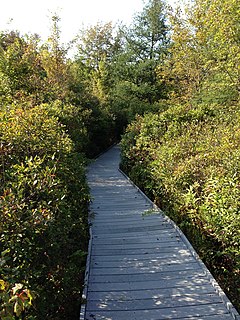
The Tannersville Cranberry Bog or Cranberry Swamp is a sphagnum bog on the Cranberry Creek in Tannersville, Pennsylvania. It is the southernmost boreal bog east of the Mississippi River, containing many black spruce and tamarack trees at the southern limit of their ranges. Technically, it can be classed as an acid fen, as it receives some groundwater flow. The site was designated a National Natural Landmark in December 1974. It was purchased by The Nature Conservancy and the Conservation and Research Foundation in 1957. Like many bogs, its terrain presents an image of solidity, but a liquid mass of decaying peat lies beneath a six-inch (152 mm) layer of sphagnum and a network of supporting tree roots. However, this bog may be viewed from a floating walkway.
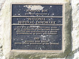
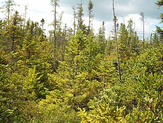
Pinhook Bog is a unique bog in Indiana that has been designated a National Natural Landmark. It is part of Indiana Dunes National Park, an area that many citizens, scientists, and politicians fought hard to preserve. Its sister bog, Volo Bog, is located nearby. The bog contains a large variety of plants, including insect eating plants, tamarack trees, stands of blueberry bushes, and floating mats of sphagnum moss. Pinhook Bog is about 580 acres (2.3 km2), a quarter of which is a floating mat of sphagnum peat moss. A "moat" separates the bog from the uplands.

Cowles Bog is an 8,000-year-old wetland complex in Indiana Dunes National Park, near Chesterton, Indiana. It is named for Dr. Henry Chandler Cowles who did his pioneering work in ecology and ecological succession here. His work brought international attention to the area which led to efforts to preserve the Indiana Dunes. It was designated a National Natural Landmark in 1965. It contains bog, fen, marsh, wet meadow, swamp, and pond habitats.

Volo Bog State Natural Area is a nature reserve in Illinois, United States, preserving Volo Bog. The bog was designated a National Natural Landmark in 1973 as the only remaining open-water quaking bog in Illinois. The site also contains woodlands, savanna, marshes, prairie restoration areas, shrubland and old fields. Maintained by the Illinois Department of Natural Resources, the site is located about a mile west of U.S. Route 12 between the towns of Volo and Fox Lake, Illinois.
The Tom S. Cooperrider - Kent Bog State Nature Preserve is state nature preserve located in Kent, Ohio. The preserve surrounds the Kent Bog, a remnant of the Wisconsin Glaciation. It is a true bog with acidic waters and unique environmental conditions have enabled it to survive. The bog contains the largest stand of tamarack trees in the state of Ohio.

The Indiana Dunes comprise ten different habitats. Each provides for a unique combination of plants and animals. The range of the Indiana Dunes varies depending your source. The Indiana Lake Michigan Coastal Program uses the river drainage systems along the shoreline. This expands the area from the areas of lakeshore southward to the edges of the Valparaiso Moraine. This entire region has been dune landscapes since over 114,000 years before present (YBP). Traditionally, the Indiana Dunes area thought of as a narrow area along the shores of Lake Michigan, including the areas of Marquette Park in Gary, Indiana (1920), Indiana Dunes State Park (1926) and Indiana Dunes National Park,. The identified ten habitats can be found in these parks, where they have been preserved, but are also visible throughout the three counties of Northwest Indiana.

The Hackmatack National Wildlife Refuge is a newly established United States national wildlife refuge that will include noncontiguous properties, especially tallgrass prairie patches, wetland properties, and oak savanna parcels, located in the northwestern region of the Chicago metropolitan area and the southern part of the Milwaukee area. The refuge's boundaries encompass parts of McHenry County, Illinois, and Walworth County, Wisconsin. The refuge will be operated by the United States Fish and Wildlife Service, known as USFWS. 85 percent of the refuge will be in Illinois, and 15 percent in Wisconsin.

Pigeon River Fish and Wildlife Area is a protected area that covers 12,134 acres (4,910 ha) and is dedicated to providing hunting and fishing opportunities. The area includes 529 acres (214 ha) of lakes and 17 miles (27 km) along the Pigeon River. It is located on Indiana State Road 3, near Mongo in Lagrange County, Indiana. The Fish and Wildlife Area contains Tamarack Bog Nature Preserve, a 150-acre (61 ha) wetland parcel that has been designated as a National Natural Landmark.

Grandma Lake Wetlands State Natural Area is a Wisconsin Department of Natural Resources-designated State Natural Area featuring the undeveloped, pristine 44-acre Grandma Lake, which lies in a depression formed during the last glacial period. The lake is ringed by a large, open sphagnum bog mat. The bog mat is surrounded by a coniferous swamp of tamarack and black spruce. The bog mat supports a plant community that is considered diverse and unusual, with several rare species present, including: bog arrow-grass, dragon's mouth orchid, livid sedge, small-headed bog sedge, as well as one of only a few known populations of bog rush in the State of Wisconsin. In 1991, the US Forest Service designated the site as a Research Natural Area. Also, the site is listed as one of Wisconsin's Wetland Gems, by the Wisconsin Wetlands Association.
The Espy Bog is wetland complex in Columbia County, Pennsylvania, in the United States. It is situated near Bloomsburg and Espy. The wetlands contain a lake, as well as forested swamps, shrub swamps, and graminoid openings. The lake in the wetland complex may be manmade. The predominant soil in the area is known as mucky peat. The wetland complex has a high level of plant and animal biodiversity, including birds, turtles, fish, trees, shrubs, and ferns.
The Mantua Bog State Nature Preserve is a 104.8-acre (42.4 ha) protected wetland in Mantua Township, Portage County in the U.S. state of Ohio. It was designated a National Natural Landmark in 1976 and a state nature preserve in 1990. The national landmark designation encompasses 285 acres (115 ha) which includes Marsh Wetlands State Nature Preserve, in addition to Mantua Bog State Nature Preserve.