Wear Cove

Last updated
Coves of the northeast Great Smoky Mountains Smokies-coves-tn1.jpg
Coves of the northeast Great Smoky Mountains

Wear Cove is a valley in southwestern Sevier County, Tennessee. It runs parallel to the Great Smoky Mountains National Park just to its south. Like other park border regions, the history and economy of the valley are intertwined with that of the Smokies. The primary community is Wears Valley.

Contents

Wear Cove is a type of valley known as a "limestone window", created when erosion weathers through the older Precambrian sandstone and exposes the younger Paleozoic limestone beneath. The northern rim of the Smokies is dotted with limestone coves, the most well-known of which are Cades Cove and Tuckaleechee Cove. Limestone coves contain very fertile soil which lured early settlers.

Wear Cove is hemmed in by Cove Mountain to the southeast, Roundtop to the southwest, Davis Mountain to the northwest, and Hatcher Mountain to the northeast. Numerous hollows cut into the ridges throughout the cove, including Happy Hollow, Smith Hollow, and Little Cove.

U.S. Route 321 is the valley's main road, connecting Townsend in the west with Pigeon Forge in east, where it merges with U.S. Route 441. This section of 321 is known as "Wears Valley Road". Lyon Springs Road connects Wears Valley Road with Little River Road inside the national park, crossing the gap between Cove Mountain and Roundtop and emerging at the Metcalf Bottoms campground.

History

Early settlement

Aaron Crowson's grave at Crowson Cemetery in Wears Valley Wv-crowsongrave2.jpg
Aaron Crowson's grave at Crowson Cemetery in Wears Valley

The valley was originally named “Crowson Cove” after Aaron Crowson who first settled in the area in 1792. By 1900, however, it was renamed “Wear Cove” after Samuel Wear (1753–1817), a Revolutionary War veteran who erected a fort near the entrance to the valley in what is now Pigeon Forge.

Crowson arrived in Wear Cove from North Carolina in 1792 along with his friend, Peter Percefield. This was a period of elevated strife between the Cherokee and the fast-encroaching Euro-American settlers. Wear's Fort was attacked in 1793, with Wear leading a punitive march against the Cherokee village of Tallassee shortly thereafter. In May 1794, Percefield was killed in a Cherokee attack. Crowson rode to Wear's Fort to get help, but the Cherokee had fled by the time he returned. Several settlers marched onward to Great Tellico to the west, where they murdered four Cherokee while they slept. Percefield was buried on a hill in the eastern half of Wear Cove in what is now Crowson Cemetery. Later that year, Crowson received a land grant for this plot of land. [1]

Along with Crowson, other early settlers in the cove included a Revolutionary War veteran named William Headrick, who arrived in 1821, and John Ogle, a War of 1812 veteran and son of the first settlers in Gatlinburg. Another War of 1812 veteran, Peter Brickey (1769–1856), arrived in 1808. Brickey operated a large farm and distillery in the valley until his death in 1856. The log home he built shortly after his arrival still stands in Smith Hollow (between Wears Valley and Townsend) and is listed on the National Register of Historic Places. [2]

The Peter Brickey House, constructed ca. 1808 Wv-brickeyhouse3.jpg
The Peter Brickey House, constructed ca. 1808

Like many other farms in the cove, the Brickey farm was ravaged by the U.S. Civil War. Isaac Trotter, who operated the iron forge at Pigeon Forge reported a Cherokee raid in Wear Cove in 1864. [3] Earlier in the war, a Union army passed through the valley en route to dislodge the troops of Will Thomas who were entrenched in Gatlinburg. [4]

Sometime after the war, Alfred Line established a farm at the base of Roundtop Mountain, near the southern half of Wear Cove. Line Spring, a clear mountain spring which flows down from the slopes of Roundtop, gave its name to a small recreational area that developed in this part of the cove. In the 1880s and 1890s, mineral-rich mountain springs were thought to have health-restoring qualities, and provided an early form of tourism for the mountain regions. In 1910, D.B. Lawson, the son of a circuit rider who had purchased the Line farm, constructed the Line Spring Hotel. The hotel boosted the valley's economy by providing a market for local farmers. [1]

Religion

Headrick Chapel, constructed in 1902 Wv-headrick4.jpg
Headrick Chapel, constructed in 1902

Around 1800, Crowson and several other settlers erected a crude log church known as the Bethlehem Church. The church was used by both Methodists and Baptists throughout the 1800s, with Baptist services being conducted by an elected pastor and Methodist services being conducted by circuit riders. On occasion, both congregations would meet in a mini-revival known as a "union meeting". In 1886, both Baptists and Methodists constructed separate structures, although union meetings were still fairly common. [1]

For most of the 19th century, funerals in the valley were held at Headrick Cemetery, near the valley's western entrance. A large oak tree provided shelter for funeral-goers, although cold weather and rain often made apparent the need for a building in which to conduct indoor services. In 1902, according to local lore, the oak tree was destroyed by lightning, and in response, the residents erected Headrick Chapel on the cemetery's grounds. The chapel was shared by four Baptist and Methodist congregations, with funeral services having priority. The chapel's bell would ring once for every year of the deceased's life, a tradition still observed by the inhabitants of Wears Valley. In 2001, Headrick Chapel was placed on the National Register of Historic Places. [5]

The national park

The Wear Cove entrance to the GSMNP on Lyon Spring Road Wv-parkentrance3.jpg
The Wear Cove entrance to the GSMNP on Lyon Spring Road

In 1934, the Great Smoky Mountains National Park was established. The park's border paralleled Wear Cove to the south, following the crest of Roundtop and Cove Mountain. With improvements to US-321 in the 1950s, tourist outlets began to trickle into the cove. Cabin rentals and outdoor supply stores are among the more common tourism-oriented venues in the valley today.

In 2005, a group of developers led by Ron Ogle and Jerry Miller sought to build 400 houses on the slopes of Cove Mountain. This raised concern among many valley residents over the impact such development might have on Cove Mountain's scenic value. In 2007, Friends of Wears Valley a group opposed to the development unsuccessfully petitioned the Sevier County Regional Planning Commission to block the housing expansion on Cove Mountain. The group has posted "Save Our Mountains" signs throughout the valley, although the developers insist their plans will not harm the mountain's natural qualities. [6] [7]

Related Research Articles

<span class="mw-page-title-main">Sevier County, Tennessee</span> County in Tennessee, United States

Sevier County is a county of the U.S. state of Tennessee. As of the 2020 census, the population was 98,380. Its county seat and largest city is Sevierville. Sevier County comprises the Sevierville, TN Micropolitan Statistical Area, which is included in the Knoxville-Morristown-Sevierville, TN Combined Statistical Area.

<span class="mw-page-title-main">Gatlinburg, Tennessee</span> City in Tennessee, United States

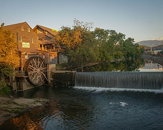
Gatlinburg is a mountain resort city in Sevier County, Tennessee. It is located 39 miles (63 km) southeast of Knoxville and had a population of 3,944 at the 2010 Census and a U.S. Census population of 3,577 in 2020. It is a popular vacation resort, as it rests on the border of Great Smoky Mountains National Park along U.S. Route 441, which connects to Cherokee, North Carolina, on the southeast side of the national park. Prior to incorporation, the town was known as White Oak Flats, or simply White Oak.

<span class="mw-page-title-main">Pigeon Forge, Tennessee</span> City in Tennessee, United States

Pigeon Forge is a mountain resort city in Sevier County, Tennessee, United States. As of the 2020 census, the city had a total population of 6,343. Situated just 5 miles (8 km) north of Great Smoky Mountains National Park, Pigeon Forge is a tourist destination that caters primarily to Southern culture and country music fans. The city's attractions include Dollywood and Dollywood's Splash Country, WonderWorks, Alcatraz East Crime Museum, as well as numerous gift shops, outlet malls, amusement rides, and musical theaters.

<span class="mw-page-title-main">Pittman Center, Tennessee</span> Town in Tennessee, United States

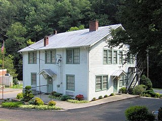
Pittman Center is a town in Sevier County, Tennessee, United States. The population was 454 at the 2020 census and 502 at the 2010 census. The town borders Gatlinburg and the Great Smoky Mountains National Park. U.S. 321 passes through the town.

<span class="mw-page-title-main">Great Smoky Mountains National Park</span> National park in Tennessee and North Carolina

Great Smoky Mountains National Park is an American national park in the southeastern United States, with parts in North Carolina and Tennessee. The park straddles the ridgeline of the Great Smoky Mountains, part of the Blue Ridge Mountains, which are a division of the larger Appalachian Mountain chain. The park contains some of the highest mountains in eastern North America, including Clingmans Dome, Mount Guyot, and Mount Le Conte. The border between the two states runs northeast to southwest through the center of the park. The Appalachian Trail passes through the center of the park on its route from Georgia to Maine. With 14.1 million visitors in 2021, the Great Smoky Mountains National Park is the most visited national park in the United States.

<span class="mw-page-title-main">Great Smoky Mountains</span> American mountain range along North Carolina/Tennessee border

The Great Smoky Mountains are a mountain range rising along the Tennessee–North Carolina border in the southeastern United States. They are a subrange of the Appalachian Mountains and form part of the Blue Ridge Physiographic Province. The range is sometimes called the Smoky Mountains, and the name is commonly shortened to the Smokies. The Smokies are best known as the home of the Great Smoky Mountains National Park, which protects most of the range. The park was established in 1934 and, with over 11 million visits per year, is the most visited national park in the United States.

<span class="mw-page-title-main">Little Pigeon River (Tennessee)</span> River in Tennessee, United States

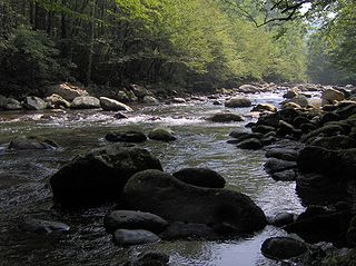
The Little Pigeon River is a river located entirely within Sevier County, Tennessee. It rises from a series of streams which flow together on the dividing ridge between the states of Tennessee and North Carolina, with most of the flow from inside the boundary of the Great Smoky Mountains National Park. The river has three main forks or prongs, East, Middle, and West.

<span class="mw-page-title-main">Cades Cove</span> Valley within the Great Smoky Mountains

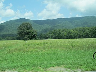
Cades Cove is an isolated valley located in the Tennessee section of the Great Smoky Mountains National Park. The valley was home to numerous settlers before the formation of the national park. Cades Cove, the single most popular destination for visitors to the park, attracts more than two million visitors annually because of its well preserved homesteads, scenic mountain views, and abundant display of wildlife. The Cades Cove Historic District is listed on the National Register of Historic Places.

<span class="mw-page-title-main">Foothills Parkway</span> National parkway in Tennessee

The Foothills Parkway is a national parkway which traverses the foothills of the northern Great Smoky Mountains in East Tennessee, located in the southeastern United States. The 72.1-mile (114 km) parkway will connect U.S. Route 129 along the Little Tennessee River in the west with Interstate 40 (I-40) along the Pigeon River in the east.

<span class="mw-page-title-main">The Sugarlands</span> Valley in the north-central Great Smoky Mountains

The Sugarlands is a valley in Tennessee within the north-central Great Smoky Mountains, located in the southeastern United States. Formerly home to a string of small Appalachian communities, the valley is now the location of the Great Smoky Mountains National Park headquarters and the Sugarlands Visitor Center. Lying just south of Gatlinburg, the Sugarlands is one of the park's most popular access points.

<span class="mw-page-title-main">Cosby, Tennessee</span> Census-designated place in Tennessee, United States

Cosby is a census-designated place (CDP) and unincorporated community in Cocke County in the U.S. state of Tennessee. The population of the Cosby CDP according to the 2020 census was 807. The community has given its name to the northeastern section of the Great Smoky Mountains National Park, which forms its southern boundary. Cosby's zip code also extends to into Sevier County, and borders the town of Pittman Center.

<span class="mw-page-title-main">Wears Valley, Tennessee</span> Unincorporated community in Tennessee, United States

Wears Valley is an unincorporated community in Sevier County, Tennessee that was formerly treated by the U.S. Census Bureau as a census county division. As of the 2000 Census, the population of Wears Valley was 6,486.

<span class="mw-page-title-main">Little Greenbrier (Great Smoky Mountains)</span> Historic community in Tennessee.

Little Greenbrier is the name of a former Appalachian community that is now an historical area in the Great Smoky Mountains of East Tennessee. The community was situated in a valley rising from Metcalf Bottoms along Little River to the upper slopes of Cove Mountain, in the northeastern section of the Great Smoky Mountains National Park. Little Greenbrier was once known simply as "Greenbrier," but "Little" was added to distinguish it from the larger Greenbrier located between Mount Le Conte and Mount Guyot to the east.

<span class="mw-page-title-main">Roaring Fork (Great Smoky Mountains)</span> Stream in Tennessee

Roaring Fork is a stream in the Great Smoky Mountains of Tennessee, located in the southeastern United States. Once the site of a small Appalachian community, today the stream's area is home to the Roaring Fork Motor Nature Trail and the Roaring Fork Historic District.

<span class="mw-page-title-main">Greenbrier (Great Smoky Mountains)</span> Valley in Sevier County, Tennessee

Greenbrier is a valley in the northern Great Smoky Mountains of Tennessee, located in the southeastern United States. Now a recreational area located within the Great Smoky Mountains National Park, Greenbrier was once home to several Appalachian communities.

<span class="mw-page-title-main">Cataloochee (Great Smoky Mountains)</span> Valley in North Carolina, United States

Cataloochee is a valley in the Great Smoky Mountains of North Carolina, located in the Southeastern United States. Now a recreational and historic area within the Great Smoky Mountains National Park, Cataloochee was once home to a substantial Appalachian community and Cherokee hunting ground.

<span class="mw-page-title-main">Walland, Tennessee</span> CDP in Tennessee, United States

Walland is an unincorporated community and census-designated place (CDP) in Blount County, Tennessee. Its population was 281 as of the 2020 census. Walland is the site of a post office and is the place name associated with zip code 37886, which covers an area beyond the Walland community.

<span class="mw-page-title-main">Roundtop Trail</span>

The Roundtop Trail is an American hiking trail in Sevier County and Blount County sections of the Great Smoky Mountains National Park. The trail traverses the crest of Roundtop, a 3,077-foot (938 m) mountain that straddles the park's northern boundary. This trail, which passes through a thick forest of pine and oak and provides vistas of the valleys to the north and the mountains to the south, is one of the least-used trails in the park.

<span class="mw-page-title-main">Sugarland Mountain Trail</span> Hiking trail in Sevier County, Tennessee

The Sugarland Mountain Trail is an American hiking trail, in the Great Smoky Mountains National Park of Sevier County, Tennessee. The trail traverses Sugarland Mountain, a massive ridge running perpendicular to the main crest of the Smokies and effectively dividing the park's north-central section from its northwestern section. Sugarland Mountain is flanked by the deep upper valleys of two of the park's major watersheds— the West Fork of the Little Pigeon River and Little River. The trail passes through several forest types, including deciduous forest at lower elevations, heaths ("hells") along the mountain's backbone formations, and a stand of Southern Appalachian spruce-fir forest in the upper elevations. Occasional breaks in the foliage allow for views of Mount Le Conte and Sevier County to the east and Blanket Mountain and the ridges above Elkmont to the west.

Samuel Wear was an American War of Independence soldier who fought at the Battle of Kings Mountain. He was one of the early inhabitants of, and a founder of, the "Lost State of Franklin". He later helped draft the Constitution of the State of Tennessee.

References

  1. 1 2 3 Ida Headrick Myers, "Recollections of Wears Valley," The Sevier County News-Record, 1953. (http://www.headrickchapel.org/wears_valley.shtml) Retrieved: 16 July 2007.
  2. The Center for Historic Preservation, "Tennessee Century Farms—Blount County" (http://histpres.mtsu.edu/centfarms/blount_county/#Brickey_Farm) retrieved: 16 July 2007.
  3. D.M.G. Emert, Beulah Linn (editor), "The Isaac Trotter Papers," Smoky Mountain Historical Society Newsletter 12, no. 2 (Summer of 1986): 31.
  4. Beulah Linn, Reunion At the River: Official History of Pigeon Forge, Tennessee 1783-1930 (Pigeon Forge Homecoming '86 Committee, 1986), 10-20.
  5. David Frye, "Headrick Chapel: Symbol of a Rural East Tennessee Community," Smoky Mountain Historical Society Journal 18, no. 4 (Winter of 2004): 2. (http://www.headrickchapel.org/davids_article.shtml) Retrieved: 16 July 2007.
  6. Craig Mintz, "Wears Valley Friends To Meet," The Mountain Press, 27 September 2005.
  7. Greg Johnson, "Doomsday Development On Cove Mountain," The Knoxville News-Sentinel, 4 May 2007. (NOTE: the Johnson article is an op-ed, and bias should be taken into account).

35°42′50″N83°39′11″W / 35.71393°N 83.65315°W / 35.71393; -83.65315