
The Peak District is an upland area in England, at the southern end of the Pennines. Mostly in Derbyshire, it extends into Cheshire, Greater Manchester, Staffordshire, West Yorkshire and South Yorkshire. It is subdivided into the Dark Peak, moorland dominated by gritstone, and the White Peak, a limestone area with valleys and gorges. The Dark Peak forms an arc on the north, east and west of the district, and the White Peak covers central and southern areas. The highest point is Kinder Scout. Most of the area is within the Peak District National Park, a protected landscape designated in 1951.

Derbyshire is a ceremonial county in the East Midlands of England. It borders Greater Manchester, West Yorkshire, and South Yorkshire to the north, Nottinghamshire to the east, Leicestershire to the south-east, Staffordshire to the south and west, and Cheshire to the west. Derby is the largest settlement, and Matlock is the county town.

The Pennines, also known as the Pennine Chain or Pennine Hills, are a range of uplands mainly located in Northern England. Commonly described as the "backbone of England" because of its length and position, the range runs from Derbyshire and Staffordshire in the North Midlands to Northumberland in North East England, near the Anglo-Scottish border. The range starts near the valley of the River Trent to the south and extends northwards across the Peak District, South Pennines, Yorkshire Dales, and North Pennines, ending at the Tyne Gap. Beyond the gap are the Border Moors and Cheviot Hills, which are included in some definitions of the range.

Ashbourne is a market town in the Derbyshire Dales district in Derbyshire, England. Its population was measured at 8,377 in the 2011 census and was estimated to have grown to 9,163 by 2019. It has many historical buildings and independent shops. The town offers a historic annual Shrovetide football match. Its position near the southern edge of the Peak District makes it the closest town to Dovedale, to which Ashbourne is sometimes referred to as the gateway.

The White Peak, also known as the Low Peak, is a limestone plateau that forms the central and southern part of the Peak District in England. It is mostly between 270 metres (900 ft) and 430 metres (1,400 ft) above sea-level and is enclosed by the higher altitude Dark Peak to the west, north and east.

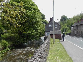
Ilam is a village in the Staffordshire Peak District of England, lying on the River Manifold. The population of the civil parish as taken at the 2011 census was 402.

The A52 is a major road in the East Midlands, England. It runs east from a junction with the A53 at Newcastle-under-Lyme near Stoke-on-Trent via Ashbourne, Derby, Stapleford, Nottingham, West Bridgford, Bingham, Grantham, Boston and Skegness to the east Lincolnshire coast at Mablethorpe. It is approximately 147 miles (237 km) long.

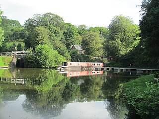
Caldon Canal is a branch of the Trent and Mersey Canal which opened in 1779. It runs 18 miles (29 km) from Etruria, Stoke-on-Trent, to Froghall, Staffordshire. The canal has 17 locks and the 76-yard (69 m) Froghall Tunnel.
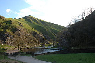
Dovedale is a valley in the Peak District of England. The land is owned by the National Trust and attracts a million visitors annually. The valley was cut by the River Dove and runs for just over 3 miles (5 km) between Milldale in the north and a wooded ravine, near Thorpe Cloud and Bunster Hill, in the south. In the wooded ravine, a set of stepping stones cross the river and there are two caves known as the Dove Holes.
Ellastone is a village in the East Staffordshire borough of Staffordshire, in the West Midlands of England. It is on the Staffordshire side of the River Dove and is directly opposite the village of Norbury in Derbyshire. It is between Uttoxeter and Ashbourne.
Waterhouses is a village in the south of the Staffordshire Peak District in England. It is around 8 miles from Leek and Ashbourne, being nearly the halfway point between the two towns on the A523 road, which roughly follows the southern boundary of the Peak District National Park. Waterhouses is also a civil parish, created in 1934 when the parishes of Calton, Cauldon, Waterfall and part of Ilam were merged; previously the village of Waterhouses was on the boundary of Waterfall and Cauldon parishes. The hamlet of Winkhill is also in the parish. The population of the civil parish at the 2011 census was 1,134.

Parkhouse Hill is a small but distinctive hill in the Peak District National Park of the Hartington Middle Quarter civil parish, in the English county of Derbyshire. It lies on the north side of the River Dove, close to the border with Staffordshire.

Stanton is a small village situated at the eastern end of the Weaver Hills, Staffordshire, England.

Thorpe is a village and civil parish in the English county of Derbyshire; it is on the Derbyshire/Staffordshire border, on the east bank of the River Dove, about four miles north of Ashbourne. The population of the civil parish as at the 2011 census was 183.
Froghall is a village situated approximately ten miles to the east of Stoke-on-Trent and two miles north of Cheadle in Staffordshire, England. Population details as taken at the 2011 Census can be found under Kingsley. Froghall sits in the Churnet Valley, a beautiful and relatively unspoilt part of Staffordshire. There are some excellent and challenging walks in the area, many of which encompass the area's historic development by the coal, ironstone, copper and limestone industries.

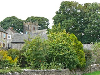
Parwich is a village and parish in the Derbyshire Dales, 7 miles north of Ashbourne. In the 2011 census the population of the civil parish was 472.
Wetton is a village in the Peak District National Park, North Staffordshire, at the top of the east side of the Manifold Valley. The population recorded in the 2001 Census was 157. At the time of the 2011 Census the population was recorded under Ilam. This article describes the location, some of the main features of the village, and a number of places of historical or general interest in or near the village. These include Long Low, Wetton, a prehistoric burial site unique to England.
The Waterhouses branch line was a railway built by the North Staffordshire Railway to link the small villages east of Leek, Staffordshire with Leek, the biggest market town in the area. The railway opened in 1905 but closed to passengers in 1935. Freight continued on the line though until 1988, when the line was mothballed as the traffic from the quarries at Caldon Low ceased.

The Peak District Boundary Walk is a circular 190-mile (310 km) walking trail, starting and finishing at Buxton and broadly following the boundary of the Peak District, Britain's first national park. The route was developed by the Friends of the Peak District and was launched on 17 June 2017.

The Wye Valley is the limestone valley of the River Wye in the White Peak of Derbyshire, England. The source of the River Wye is west of Buxton on Axe Edge Moor. One main channel runs underground through Poole's Cavern. The river flows though Buxton Pavilion Gardens and then along a culvert under the town centre. After leaving the flat area of central Buxton, the Wye Valley becomes distinct as a gorge running east for 10 miles (16 km) before the valley broadens at Ashford-in-the Water.


