The Tararua District is a district near the south-east corner of New Zealand's North Island that is administered by the Tararua District Council. It has a population of 19,050, and an area of 4,364.65 km². The Tararua District Council was created by the amalgamation of the Dannevirke Borough, Eketahuna County Council, Pahiatua Borough Council, Pahiatua County Council and Woodville District Council in the 1989 local government reforms.

Takapau is a small rural community in the Central Hawkes Bay in New Zealand. It is located 20 kilometres west of Waipukurau, off State Highway 2, and has a population of more than 500.

Pukekohe railway station is a railway station in Pukekohe, New Zealand. It is the southern terminus of the Southern Line of the Auckland railway network. The station has an island platform between the main lines and an original wooden station building complete with signal panel.
The Old Bed of Waipawa River is a river of the Hawke's Bay region of New Zealand's North Island. It flows roughly parallel with and north of the Waipawa River, which it almost meets to the east of Waipawa. It flows into the Tukituki River via the Papanui Stream, south west of Lake Poukawa. The Waipawa changed its course during a flood in 1868. In the Cyclone Gabrielle event of February 2023 the flooded river broke its banks south of Waipapa town and reverted to its old bed, causing significant damage to farms and property. The Coronation Park stop bank in Waipawa was repaired on 16 February, returning the Waipawa to its post 1868 course.

William Cowper Smith was a Liberal Party Member of Parliament in New Zealand.
Henry Robert Russell was a notable New Zealand runholder and politician. He was baptised in Dunfermline, Fife, Scotland on 11 February 1817. He was appointed to the New Zealand Legislative Council on 12 July 1862. His membership lapsed on 11 June 1885 after he had been absent for two sessions. He was considered to be the founder of Waipukurau, where he owned the Mount Herbert estate, to the east of the town. His brother, Thomas Purvis Russell, owned the neighbouring Woburn estate and they also owned runs near the Turanganui River in southern Wairarapa. He left an estate of £100,765.

Oruawharo Homestead is an historic homestead built in 1879 in Takapau, Central Hawke's Bay, New Zealand. It was designed by Wellington architect Charles Tringham in the Italianate style and built from native timbers for Sydney and Sophia Johnston by Sydney's father, the politician and merchant John Johnston. Johnston senior of Wellington was the original purchaser of the run in the 1850s. Sydney Johnston had the nearby Takapau township surveyed in 1876.

Te Horo railway station was a flag station at Te Horo, in the Kapiti Coast District on the North Island Main Trunk in New Zealand.It was served by diesel shuttles between Te Horo and Wellington. Only equipment sheds and a passing loop now remain at the station site.

Greatford railway station was a station on the North Island Main Trunk (NIMT) in New Zealand, south of Marton. It is in the Manawatū-Whanganui region. Only a substation and a passing loop remain.
Kakariki railway station was a station on the North Island Main Trunk and in the Manawatū-Whanganui region of New Zealand.

Te Mawhai railway station was a flag station on the North Island Main Trunk in New Zealand. Its primary traffic was supplies to the nearby Tokanui Psychiatric Hospital. The hospital was situated to be convenient for freight and passengers by rail and a light railway connection to the hospital was considered.

Go Bus Transport Ltd is a large bus company in New Zealand owned by Australian-based transport operator Kinetic Group. The company is based in Hamilton, New Zealand, and runs bus services in Hamilton, Hawke's Bay, Tauranga, Christchurch, Gisborne, Dunedin and Invercargill.
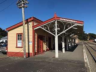
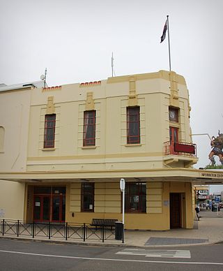
Ormondville is a locality in the Manawatū-Whanganui region of New Zealand's North Island. It is located inland, south of Waipukurau and west of Flemington, Hawke's Bay.

Opapa railway station is a preserved station, probably dating from 1896, on the Palmerston North–Gisborne Line in Hastings District of Hawke's Bay, 23.56 km (14.64 mi) south of Hastings in New Zealand's North Island. Although it closed in 1981 and is now in a meshblock with a 2018 population of only 222, Te Aute is unusual in 3 respects:

Matamau is a small village, on a ridge between the Matamau and Whakaruatapu Streams, tributaries of the Manawatū River, in the Manawatū-Whanganui region of New Zealand's North Island. State Highway 2 and the Palmerston North–Gisborne line run through the village. It has a rare surviving example of a basic railway station, a cafe, developed from the former post office and store about 1969, and a truck repair workshop. Until the 1870s it was densely forested, but most of the trees were felled and milled by 1910 and replaced by farms.
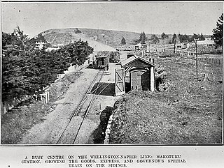
Makotuku is a locality in the Manawatu-Whanganui Region of New Zealand's North Island, about 3 km2 (1.2 sq mi) west of Ormondville.
Hatuma is 7 km (4.3 mi) south of Waipukurau, in Central Hawke's Bay in the east of the North Island of New Zealand. Meshblock 7016748, which covers 19.3 km2 (7.5 sq mi) from the edge of Waipukurau to Marakeke, had a population of 153 in 2018.
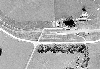
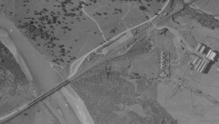
Kopua in New Zealand is now a sparsely populated area, immediately south of the border of the Manawatū-Whanganui and Hawke's Bay regions, with 150 people scattered over a 40 km2 (15 sq mi) meshblock. For two years it briefly flourished as a village, centred on a railway station on the Palmerston North–Gisborne line, opened on 25 January 1878, when it became the southern terminus of the line from Napier and Spit. Building to the south was delayed by the need to erect 3 large viaducts over the Manawatū River and its tributaries, so the extension to Makotuku didn't open until 9 August 1880. Kopua then declined until the station closed on 8 May 1977. Only a single line now passes through the station site and there are remnants of cattle yards.
The Tamaki River is a river in the Manawatū-Whanganui region of New Zealand's North Island. Tamaki River starts at the confluence of two parallel rivers, the Tamaki River West and Tamaki River East Branches. The west Branch flows south from its source on the slopes of Takapari, in the Ruahine Range.

Piripiri is a sparsely populated area in the Manawatū-Whanganui region, on State Highway 2 and the Palmerston North–Gisborne line. It is 3 mi 8 ch (5.0 km) north of Dannevirke, and has 150 people scattered over a meshblock of 21.8 km2 (8.4 sq mi).
