Species listed
- Plants found and photographed NSW Weeping Myall Woodlands


 Capparis lasiantha in front of Warrior Bush, Apophylla anomalum , and both under a weeping myall, Acacia pendula .
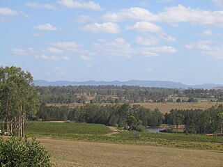
The Weeping Myall Woodlands is an endangered ecological community, under the EPBC Act of the Commonwealth of Australia. [1] It is found in inland Queensland and inland New South Wales, [1] on alluvial plains west of the Great Dividing Range. [2] It takes its name from Acacia pendula , the weeping myall.
The Weeping Myall woodlands ecological community in New South Wales has been named as the Myall Woodland in the Darling Riverine Plains, Brigalow Belt South, Cobar Peneplain, Murray-Darling Depression, Riverina and NSW South Western Slopes bioregions. [3]
This ecological community has been listed as endangered under the Commonwealth EPBC Act since 7 January 2009. [1] The key threats are clearing and ongoing degradation since this ecological community occurs on highly fertile and arable soils. Other threats are overgrazing and weed invasion. [2]
In New South Wales it is also listed as an endangered ecological community, first under the NSW Threatened Species Conservation Act 1995 and now under the Biodiversity Act of 2016 . [3]
It occurs in the IBRA regions of Riverina, NSW South Western Slopes, Darling Riverine Plains, Brigalow Belt South, Brigalow Belt North, Murray-Darling Depression, Nandewar and Cobar Peneplain, in small pockets. [2]


Goobang is a national park located in New South Wales, Australia, 296 kilometres (184 mi) northwest of Sydney. It protects the largest remnant forest and woodland in the central west region of the state, where interior and coastal New South Wales flora and fauna species overlap. Originally named Herveys Range by John Oxley in 1817, the area was reserved in 1897 as state forest because of its importance as a timber resource, and was designated a national park in 1995.
Erringibba is a national park at Glenmorgan in the far west of the Darling Downs region of southern Queensland, Australia, 329 km west of Brisbane. The park was established in 1999 and covers 8.77 km2 (3.39 sq mi). The park lies within the catchment area of the Condamine River and the Brigalow Belt South bioregion.

The Hunter Region, also commonly known as the Hunter Valley, Newcastle Region or simply Hunter, is a region of New South Wales, Australia, extending from approximately 120 km (75 mi) to 310 km (193 mi) north of Sydney. It contains the Hunter River and its tributaries with highland areas to the north and south. Situated at the northern end of the Sydney Basin bioregion, the Hunter Valley is one of the largest river valleys on the NSW coast, and is most commonly known for its wineries and coal industry.

The Riverina is an agricultural region of south-western New South Wales, Australia. The Riverina is distinguished from other Australian regions by the combination of flat plains, warm to hot climate and an ample supply of water for irrigation. This combination has allowed the Riverina to develop into one of the most productive and agriculturally diverse areas of Australia. Bordered on the south by the state of Victoria and on the east by the Great Dividing Range, the Riverina covers those areas of New South Wales in the Murray and Murrumbidgee drainage zones to their confluence in the west.
In the state of New South Wales, Australia, there are many areas which are commonly known by regional names. Regions are areas that share similar characteristics. These characteristics may be natural such as the Murray River, the coastline, or the Snowy Mountains. Alternatively, the characteristics may be cultural, such as a viticulture land use. New South Wales is divided by numerous regional boundaries, based on different characteristics. In many cases boundaries defined by different agencies are coterminous.

The Brigalow Belt is a wide band of acacia-wooded grassland that runs between tropical rainforest of the coast and the semi-arid interior of Queensland and northern New South Wales, Australia. The Interim Biogeographic Regionalisation for Australia (IBRA) divides the Brigalow Belt into two IBRA regions, or bioregions, Brigalow Belt North (BBN) and Brigalow Belt South (BBS). The North and South Brigalow Belt are two of the 85 bioregions across Australia and the 15 bioregions in Queensland. Together they form most of the Brigalow tropical savanna ecoregion.

The Paroo-Darling National Park is a protected national park that is located in the Far West region of New South Wales, in eastern Australia. The 178,053-hectare (439,980-acre) national park spans two distinct regions in the outback area. This region covers the arid catchments of the Paroo River and the Paroo-Darling confluence to the south.

The Yanga National Park is a newly formed national park, located near the township of Balranald in south- western New South Wales. It covers an area of 66,734 hectares which includes 1,932 hectares of Yanga Nature Reserve, and has a frontage of 170 kilometres (110 mi) on the Murrumbidgee River. It is largely located in the Lower Murrumbidgee Floodplain, which is included on A Directory of Important Wetlands in Australia because of its importance as a breeding site for waterbirds when flooded.

The Southeast Australia temperate savanna ecoregion is a large area of grassland dotted with eucalyptus trees running north–south across central New South Wales, Australia.

The Murray Darling Depression , also known as the Murray-Darling woodlands and mallee, is a 19,717,651 HA biogeographic region and an ecoregion in southeastern Australia consisting of a wooded plain through which flow two of Australia's biggest rivers, the Murray and the Darling. There are several modern human settlements in the bioregion including Ivanhoe and Manilla, but the region also contains some of the oldest known human occupation sites in Australia.

The Yathong Nature Reserve is a protected nature reserve that is also a nationally and internationally recognized biosphere situated in the central-western region of New South Wales, in eastern Australia. The 107,240-hectare (265,000-acre) reserve was listed by UNESCO in 1977 as a Biosphere Reserve under the Man and the Biosphere Programme (MAB). The reserve is significant for its biodiversity in both native plant and animal species. Cultural heritage and historical grazing activities add to the significance of this site as a conservation area.
The Toorale National Park is a protected national park that is located in the far-west region of New South Wales, in eastern Australia. The 30,866-hectare (76,270-acre) national park is located approximately 80 kilometres (50 mi) southwest of Bourke, at the junction of the Darling and Warrego rivers. The national park is located adjacent to both the Darling River and the Gundabooka National Park, located to the south-east of the park, and the Toorale State Conservation Area, located to the north-west of the park. The park is jointly managed by the NSW National Parks and Wildlife Service and the local indigenous Kurnu-Baakandji people.

The Cooks River/Castlereagh Ironbark Forest (CRCIF) is a scattered, dry sclerophyll, open-forest to low woodland and scrubland which occurs predominantly in the Cumberland subregion of the Sydney basin bioregion, between Castlereagh and Holsworthy, as well as around the headwaters of the Cooks River. The Cooks River Clay Plain Scrub Forest is a component of this ecological community, though both belong to a larger occurring community called the Temperate Eucalyptus fibrosa/Melaleuca decora woodland.

The Delma australis is often known as the southern legless lizard, or the marble-faced delma. This terrestrial lizard falls into the category of slender Pygopodidae, a legless lizard. There are 21 known species in the Pygopdidae family in Australia. Marble-faced delmas are endemic to Australia. Delma australis was first described by Kluge in 1974.
The Central Hunter Valley eucalypt forest and woodland is a grassy woodland community situated in the Hunter Valley, New South Wales, Australia. It was listed in May 2015 as critically endangered under Australia's national environment law. The Warkworth Sands Woodland of the Hunter Valley, situated in the area, was gazetted as an endangered ecological community in New South Wales on 13 December 2002 under the NSW Threatened Species Conservation Act 1995 and now under the Biodiversity Act of 2016.

The Iron-grass Natural Temperate Grassland of South Australia is a temperate grassland in the southeast of South Australia that stretches from Orroroo in the north, to Strathalbyn in the south, just straddling the eastern fringes of Adelaide's Mount Lofty Ranges. Listed as Critically Endangered under the EPBC Act, the grasslands predominantly feature Iron-grasses.

Dharrday in Yuwaalayaay language

Idiosoma planites is a species of mygalomorph spider in the Idiopidae family. It is endemic to Australia. It was described in 1985 by Australian arachnologist Richard Faulder.