Welland Canal Bridge 13

Last updated
Welland Canal Bridge 13 (Welland Main Street Bridge)
Welland Canal bridge 13 - 1.JPG
Coordinates 42°59′30″N79°15′05″W / 42.9917°N 79.2514°W / 42.9917; -79.2514
CarriesVehicular Traffic
Crosses Welland Recreational Waterway
Locale Welland, Ontario
Characteristics
Design Vertical lift bridge
Total length70.6 metres (232 ft)
Width9.1 metres (30 ft) (roadway width)
History
Construction start1927
Construction end1930
Opened1930
Location
Welland Canal Bridge 13

Welland Canal Bridge 13 (or as more commonly known locally, the Welland bridge) is a vertical lift bridge located in the heart of downtown Welland, Ontario. The bridge crosses an abandoned portion of the Welland Canal known as the Welland Recreational Waterway.

Contents

Previous bridges at this site

Simple wooden swing bridge over the 2nd Welland Canal (1870) Welland Main Street Bridge - 2nd Canal.jpg
Simple wooden swing bridge over the 2nd Welland Canal (1870)
1930 Overview of Welland showing Bridge 13 in the distance with the third canal Alexandra Bridge relocated to Division Street just in front of it. The nearer vertical lift bridge is Bridge 14 (Lincoln Street) Welland arial - 1930.jpg
1930 Overview of Welland showing Bridge 13 in the distance with the third canal Alexandra Bridge relocated to Division Street just in front of it. The nearer vertical lift bridge is Bridge 14 (Lincoln Street)

The channel passing under this bridge is the fourth Welland Canal. A bridge has existed at this location ever since the first canal was constructed. The bridge is the location of a major historical intersection in the original roads of the Niagara Peninsula. As well as being important to local traffic in Welland, the bridge also links East Main Street (leading towards Niagara Falls) and West Main Street (providing access to roads leading along the Welland River to Wainfleet and Wellandport. It also provides a link between Niagara Street (formerly known as North Main Street leading to Thorold and St. Catharines, and King Street (formerly South Main Street, and also Canal Street), formerly leading to the Canada Southern Railway station, and on to Port Colborne.

The Chippawa Road (as Main Street was then known) crossed the First Welland Canal (constructed between 1824 and 1829 [1] ) via a wooden swing bridge with the pivot set to one side of the canal. This was turned manually by pushing on heavy wooden beams extending from the end of the bridge. [2]

The bridge over the Second Welland Canal (constructed 1840 to 1845 [1] ) is recorded in at least one image (shown at left), which has been seen in several books, in the Welland Library and on a post card. This was a swing bridge [2] of a design common to other locations on the second canal. [3] It can be seen from the picture that the pivot was to the west of the canal. These bridges were painted white and operated manually. [3]

The Third Welland Canal was constructed between 1871 and 1881 [1] and located slightly west of the second. The bridge over this canal was constructed one block south of Main Street at Division Street. This situation severed the primary commercial artery and caused hardship for local business. In winter when the canal was closed, a floating plank bridge, just 1.2m (4 feet) wide allowed pedestrian access across the canal at Main Street, but significant pressure was placed on officials to build a permanent bridge at this location. [4] Eventually, a bridge known as the Alexandra Bridge was built at Main Street in 1903. This Bridge is well documented at the Welland Public Library Local History Site. In 1927, this bridge was moved one block south to Division Street to make room for construction of the current Bridge 13. [5]

Construction

While the previous three canals were each at slightly different locations, the width of the greatly expanded fourth canal encompassed all of them. [1] Fourth canal construction started as early as 1913. There were delays as a result of World War I, and this massive project was not completed until 1932. [1]

Bridge 13 was constructed between 1927 and 1930, with steel work of the span being constructed on temporary pilings driven into the canal bed during the winter of 1929-30 (while the shipping season was closed). The bridge was built by the Dominion Bridge Company, with most of the steel work being completed by members of the Mohawk First Nation, who have a long history of being some of the finest ironworkers in North America. [6]

The bridge was the most expensive on the canal, with a construction cost of $986,363. The bridge is 9.1 metres (30 ft) wide - significantly wider than most canal bridges. [6] It was designed to carry a streetcar track down the middle, but the Welland streetcar system (the Niagara, Welland and Lake Erie railway) was slated for abandonment before the bridge was actually opened and this track was never installed. [7]

The bridge is 70.6 metres (232 ft) long and has a skew of approximately 22.5 degrees - meaning that the towers and span are off square by this amount. The reason that the skew is required can be seen from the old picture of the second canal bridge above - the canal does not run at a 90 degree angle to Main Street. While a bridge out of alignment with the road was acceptable in the 1840s, a straight road was considered essential in the 1920s. No other canal bridge is skewed to this degree. [6]

Operation and incidents

During its operational life, the bridge carried three lanes of traffic - two westbound (the middle lane being designated as through traffic to West Main Street and the right for a turn onto Niagara Street), and one eastbound lane, which was required to turn right onto King Street as East Main street has been one-way westbound since at least the mid-1950s. [8]

The bridge is located on a curve in a congested area of the canal. This led to several incidents over the years. Ships failing to negotiate the curve, on at least a couple of occasions, collided with the western approach span. The Welland Public Library holds a file of newspaper clippings regarding such collisions, including one where the ship Atomena collided with the bridge in 1970.

The last ship

The route through Welland which had crossed Main Street since the 1830s was winding and difficult. The large number of bridges, and especially a railroad swing bridge (Welland Canal, Bridge 15) made the route difficult and dangerous.

In 1967, it was decided to re-route the canal to the east of the city via the Welland By-Pass. Construction proceeded through the 1972 shipping season, and by the end of that season, work was close to completion. In the late evening hours of December 15, 1972, the Main Street Bridge raised to allow the passage of the Georgian Bay - officially the last ship through the city of Welland. In fact, the bridge was raised again the next day to allow a St. Lawrence Seaway service vessel to pass, but the Georgian Bay remains the official last passage under the bridge in most historical records. [1]

After the last ship

Downtown Welland, with Bridge 13 on the right, and the rear of the new Welland Civic Square on the left. The stone structure at the edge of the water is the aqueduct from the second Welland Canal Welland Canal downtown.jpg
Downtown Welland, with Bridge 13 on the right, and the rear of the new Welland Civic Square on the left. The stone structure at the edge of the water is the aqueduct from the second Welland Canal

Following the closure of the canal at the end of the 1972 shipping season, Bridge 13 was locked permanently in the lowered position. The stairs leading to the control cabin were removed to prevent trespassing and vehicular traffic continued to cross the bridge, without interruption from passing ships.

In 1981, a parallel bridge was built at Division Street, and the Main Street bridge became a one-way road carrying west-bound traffic only. The original three lanes were reduced to two wider lanes of traffic. [8]

The concrete counterweights continued to hang over the road, and as time went on, they began to decay and drop chunks of concrete on the road below. [9] Initially, they were encased in plywood boxes, but eventually, it was deemed necessary to remove them. In 1983, the bridge was closed to traffic and a contractor was brought in to lower, then break up the counterweights. The closure caused significant traffic issues, and after a period of time, the City of Welland decided to temporarily change the adjacent Division Street Bridge to two way traffic [10]

In 2006, the bridge was once again closed to traffic for several months to allow for major re-construction of the structural elements. This was part of a three-year overhaul program on the bridge which was completed in late 2008. Another closure occurred in 2014 to allow for repainting and preservation of the entire structure. [11]

The bridge today, and the neighbourhood around it

The bridge has become the symbol of the City of Welland. Even though the bridge towers no longer serve any practical purpose, their preservation has been given a priority owing to their historical significance. [6]

Welland is making a concerted effort to revitalize the downtown area. The new Civic Square is just a block to the east of the bridge, and an observation platform built beside the canal offers views of the bridge. Nevertheless, business has not flocked back to the downtown area. With the closure of many Welland industries and the resultant increase in numbers of persons in need, the downtown area has become home to organizations such as Goodwill and similar service groups, as opposed to significant private enterprise.

Recently, a community volunteer initiative has reclaimed a neglected parkette along the west bank of the Welland Recreational Canal, just south of Bridge 13. Named "Guerrilla Park" [12] by the volunteers, it has become a destination for one of the best views of this bridge, especially when lit up at night. It has also hosted a few art events. [13]

Recommendations for development of the bridge include installing elevators to provide access to the top of the towers as a lookout.[ citation needed ] Whatever historical significance the bridge has, it remains primarily a utilitarian transportation corridor linking major east, west, north and south corridors in the city.

The bridge has recently undergone a full structural re-coating rehabilitation in the summer of 2014. New LED lighting fixtures have been mounted on the bridge which can change colours to mark special holidays or occasions. [14]

Further reading

A web site looking at this bridge, as well as many other historical bridges in Niagara is found at Historic Bridges of Michigan and Elsewhere - Niagara Region, Ontario

Related Research Articles

<span class="mw-page-title-main">St. Catharines</span> City in Ontario, Canada

St. Catharines is the most populous city in Canada's Niagara Region, the eighth largest urban area in the province of Ontario. As of 2017, St. Catharines has an area of 96.13 square kilometres (37.12 sq mi) and 140,370 residents. It lies in Southern Ontario, 51 kilometres (32 mi) south of Toronto across Lake Ontario, and is 19 kilometres (12 mi) inland from the international boundary with the United States along the Niagara River. It is the northern entrance of the Welland Canal. Residents of St. Catharines are known as St. Catharinites. St. Catharines carries the official nickname "The Garden City" due to its 1,000 acres (4 km2) of parks, gardens, and trails.

<span class="mw-page-title-main">Welland</span> City in Ontario, Canada

Welland is a city in the Regional Municipality of Niagara in Southern Ontario, Canada. As of 2021, it had a population of 55,750.

<span class="mw-page-title-main">Thorold</span> City in Ontario, Canada

Thorold is a city in Ontario, Canada, located on the Niagara Escarpment. It is also the seat of the Regional Municipality of Niagara. The Welland Canal passes through the city, featuring lock 7 and the Twin Flight Locks.

<span class="mw-page-title-main">Welland Canal</span> Ship canal in Ontario, Canada, connecting Lake Ontario and Lake Erie

The Welland Canal is a ship canal in Ontario, Canada, and part of the St. Lawrence Seaway and Great Lakes Waterway. The canal traverses the Niagara Peninsula between Port Weller on Lake Ontario, and Port Colborne on Lake Erie, and was erected because the Niagara River—the only natural waterway connecting the lakes—was unnavigable due to Niagara Falls. The Welland Canal enables ships to ascend and descend the Niagara Escarpment, and has followed four different routes since it opened.

The Queen Elizabeth Way (QEW) is a 400-series highway in the Canadian province of Ontario linking Toronto with the Niagara Peninsula and Buffalo, New York. The freeway begins at the Peace Bridge in Fort Erie and travels 139.1 kilometres (86.4 mi) around the western end of Lake Ontario, ending at Highway 427 as the physical highway continues as the Gardiner Expressway into downtown Toronto. The QEW is one of Ontario's busiest highways, with an average of close to 200,000 vehicles per day on some sections. Major highway junctions are at Highway 420 in Niagara Falls, Highway 405 in Niagara-on-the-Lake, Highway 406 in St. Catharines, the Red Hill Valley Parkway in Hamilton, Highway 403 and Highway 407 in Burlington, Highway 403 at the Oakville–Mississauga boundary, and Highway 427 in Etobicoke. Within the Regional Municipality of Halton the QEW is signed concurrently with Highway 403. The speed limit is 100 km/h (62 mph) throughout most of its length, with the exceptions being between Hamilton and St. Catharines where the posted limit is 110 km/h (68 mph).

King's Highway 58, commonly referred to as Highway 58, is a provincially maintained highway in the Canadian province of Ontario. The route is divided into two segments with a combined length of 15.5 km (9.6 mi). The southern segment travels from Niagara Regional Road 3, formerly Highway 3, in Port Colborne, to the Highway 58A junction in the southern end of Welland, a distance of 7.2 km (4.5 mi). The northern segment begins at Highway 20 near Allanburg and travels north and west to a large junction with Highway 406 at the St. Catharines – Thorold boundary, a distance of 8.3 km (5.2 mi). An 18.1 km (11.2 mi) gap separates the two segments within Welland and Pelham. The entire route is located within the Regional Municipality of Niagara.

Chippawa is a community located within the city of Niagara Falls, Ontario.

<span class="mw-page-title-main">Ontario Highway 3</span> Ontario provincial highway

King's Highway 3, commonly referred to as Highway 3, is a provincially maintained highway in the Canadian province of Ontario which travels parallel to the northern shoreline of Lake Erie. It has three segments, the first of which travels from the Ambassador Bridge in Windsor to Highway 77 in Leamington. The second portion begins at Talbotville Royal outside of St. Thomas at Highway 4, and travels to the western city limits of Port Colborne. The road is regionally maintained within Port Colborne as Niagara Regional Road 3, but regains its provincial designation at Highway 140. Its third and final terminus is at Edgewood Park, within the Fort Erie town limits. From there, the road continues as Niagara Regional Road 3 to the Peace Bridge, where drivers can cross to the United States. The total length of Highway 3 is 258.2 km (160.4 mi), consisting of 49.2 km (30.6 mi) from Windsor to Leamington, 187.9 km (116.8 mi) from Talbotville Royal to Port Colborne and 21.1 km (13.1 mi) from Port Colborne to Edgewood Park.

King's Highway 406, commonly referred to as Highway 406, is a 400-series highway in the Canadian province of Ontario. The primary north–south route through the central portion of the Niagara Peninsula, Highway 406 connects Welland, Thorold and downtown St. Catharines to the Queen Elizabeth Way (QEW).

<span class="mw-page-title-main">Garden City Skyway</span> Highway bridge across the Welland Canal in Ontario, Canada

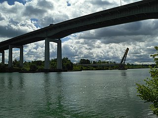
The Garden City Skyway is a major high-level bridge located in St. Catharines and Niagara-on-the-Lake, Ontario, Canada, that allows the Queen Elizabeth Way (QEW) to cross the Welland Canal without the interruption of a lift bridge. Six lanes of traffic are carried across the bridge, which is 2.2 kilometres (1.4 mi) in length and 40 metres (130 ft) at its tallest point.

King's Highway 140, commonly referred to as Highway 140, is a provincially maintained highway in the Canadian province of Ontario. The highway connects Port Colborne near Lake Erie with Highway 406 in Welland, via the Main Street Tunnel. It was constructed in the early 1970s as part of the Welland Bypass project of the Welland Canal, which resulted in the severance of several highways and rail lines. Opened to traffic in late 1972, several months following the tunnel, Highway 140 has remained unchanged since, despite growing calls to resign it as an extension of Highway 406.

<span class="mw-page-title-main">Main Street Tunnel</span>

The Main Street Tunnel, located in Welland, Ontario, Canada, is an underwater tunnel, carrying Niagara Road 27 and the unsigned designation of Highway 7146 under the Welland Canal. It is named as a part of East Main Street.

<span class="mw-page-title-main">Welland By-Pass</span>

The Welland By-pass, completed in 1973, was a massive construction project on the Welland Canal in Ontario, Canada.

<span class="mw-page-title-main">Welland Recreational Waterway</span>

The Welland Recreational Waterway is a water channel in the city of Welland, Ontario, Canada. It is an old alignment of the Welland Ship Canal that was abandoned after the construction of the Welland By-Pass in the 1970s. The Waterway is now managed by the Welland Recreational Canal Corporation to provide enjoyment for the city's residents. Most local residents refer to it as the old canal or simply the canal.

King's Highway 20, commonly referred to as Highway 20, is a provincially maintained highway in the Canadian province of Ontario. Presently, it is a short 1.9 km (1.2 mi) stub between Highway 58 and Niagara Regional Road 70 in the City of Thorold, but until 1997 it connected Hamilton to Niagara Falls, serving several towns atop the Niagara Escarpment en route.

<span class="mw-page-title-main">Downtown St. Catharines</span> Neighbourhood in St. Catharines, Ontario, Canada

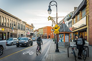
Downtown St. Catharines is the central business district of St. Catharines, Ontario, Canada. It is defined by the city as the area between Highway 406 on the west and south, Geneva Street on the east until it reaches St. Paul Street then Welland Avenue north until it meets Niagara Street.

The Niagara Parkway, formerly known as Niagara Boulevard and historically as the Niagara Road, is a scenic road in the province of Ontario that travels on the Canadian side of the Niagara River from the town of Fort Erie to Niagara-on-the-Lake. The portion north of Table Rock in the city of Niagara Falls is designated as an Ontario Scenic Highway. Niagara Boulevard originally referred only to the section from Fort Erie to Chippawa.

<span class="mw-page-title-main">Welland Canal Bridge 15</span> Bridge in Welland, Ontario

The Welland Canal Bridge 15 is a two-track Baltimore truss swing bridge located in the disused section of the Welland Canal within the city of Welland, Ontario. This section of canal is now known as the Welland Recreational Waterway. The bridge formerly carried the main line of the Canada Southern Railway (CASO) over the canal.

The Niagara, Welland and Lake Erie Railway was a street railway in Welland, Ontario, which operated from 1912 until 1930.

<span class="mw-page-title-main">Burgoyne Bridge</span> Bridge in St. Catharines, Ontario, Canada

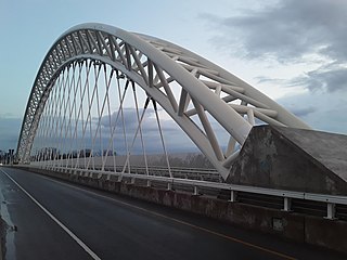
The Burgoyne Bridge is a bridge in St. Catharines, Ontario, Canada. The original bridge was built in 1915 by the Dominion Steel and Coal Corporation. In 2010, construction of a new Burgoyne Bridge was recommended by the Niagara Region. However, the project was not completed until 2016 due to the estimated cost. The new bridge is 333 meters long and features a 125-metre main span supported by a steel arch.

References

  1. 1 2 3 4 5 6 Styran, Roberta M.; Taylor, Robert R (1992). Mr. Merritt's Ditch. Erin, Ontario, Canada: Boston Mills Press. ISBN   1-55046-005-6.
  2. 1 2 Lewis, William H. (1997). Aqueduct, Merrittsville and Welland: A History of the City of Welland - The Beginning Years . Welland, Ontario, Canada: A.M.W Publications. ISBN   0-9682743-0-7.
  3. 1 2 Styran, Roberta M.; Taylor, Robert R (1988). The Welland Canals, The Growth of Mr. Merritt's Ditch. Erin. Ontario, Canada: Boston Mills Press. ISBN   0-919783-63-5.
  4. Jackson, John N. (1997). The Welland Canals and Their Communities. Toronto/Buffalo/London: The University of Toronto Press. pp. 209–210. ISBN   0-8020-0933-6.
  5. "Welland Public Library - Bridges Picture File" . Retrieved 2007-12-16.
  6. 1 2 3 4 "City of Welland: Heritage Welland - Designated Properties" . Retrieved 2007-12-15.
  7. "Transit History of Welland, Ontario" . Retrieved 2007-12-18.
  8. 1 2 "Downtown traffic patterns - no more figure eight". The Welland Tribune. 1981-06-12.
  9. "Shoring up counterweights". The Welland Tribune. 1981-03-19.
  10. "To make Division Street two-way". The Welland Tribune. 1983-07-28.
  11. "Main Street Bridge Closing for 5 Months". "The Welland Tribune. 2014-01-29.
  12. "Guerilla gardeners transform park".
  13. "Often forgotten Welland Park gets artistic".
  14. "Welland gets taste of lighted bridge | Welland Tribune". www.wellandtribune.ca. Archived from the original on 2015-08-01.

42°59′30″N79°15′05″W / 42.99167°N 79.25139°W / 42.99167; -79.25139 (Welland Canal, Bridge 13)