
Castle Hill is a suburb of Sydney, New South Wales, Australia, located 30 kilometres north-west of the Sydney central business district and 9.5 kilometres north of Parramatta. It is within the Hills District region, split between the local government areas of The Hills Shire and Hornsby Shire.

Oldbury is a market town and administrative centre in Sandwell, West Midlands, England. It is the administrative centre of the borough of Sandwell.

North Tyneside is a metropolitan borough in the metropolitan county of Tyne and Wear, England. It forms part of the greater Tyneside conurbation. North Tyneside Council is headquartered at Cobalt Park, Wallsend.

Whitley Bay is a seaside town in the county of Tyne and Wear, North East England. Historically in Northumberland, it has been administered as part of the metropolitan borough of North Tyneside since 1974 and forms part of the wider Tyneside located around 10 miles east of Newcastle upon Tyne. The former village of Monkseaton is part of the town.

Hornsby is a suburb on the Upper North Shore of Sydney in the Australian state of New South Wales 19 kilometres (12 mi) north-west of the Sydney central business district. It is the administrative centre of the local government area of Hornsby Shire.

Ashwood is a suburb in Melbourne, Victoria, Australia, 14 km south east from Melbourne's central business district. Its local government area is the City of Monash. At the 2016 Census, Ashwood had a population of 6,886.
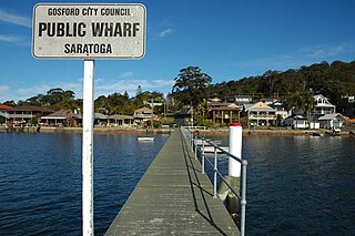
Saratoga is a residential south-eastern village and suburb of the Central Coast region of New South Wales, Australia, located on a peninsula of Brisbane Water and part of the Central Coast Council local government area. The suburb is characterised by its largely settled shoreline, with houses extending up coastal slopes to the base of the tall hills that comprise the core of the peninsula.

Kellyville is a suburb of Sydney, in the state of New South Wales, Australia 36 kilometres north-west of the Sydney central business district in the local government area of The Hills Shire. It is part of the Hills District region.

Backworth is a village in the metropolitan borough of North Tyneside in the county of Tyne and Wear, England, about 3+1⁄2 miles (6 km) west of Whitley Bay on the north east coast. It lies 5 miles (8 km) northeast of Newcastle. Other nearby towns include North Shields to the southeast, Wallsend to the south, and Cramlington to the northwest.

South Wigston is a large village to the south of Leicester, England. It is outside the city boundary, forming part of the Oadby and Wigston district of Leicestershire. The population of the ward rose slightly from 7,471 at the 2001 census to 7,490 at the 2011 census.

Sharston is an area of Wythenshawe, south Manchester, England. The population at the 2011 census was 16,754.

New Inn - - is a village and community directly south east of Pontypool, within the County Borough of Torfaen in Wales, within the historic boundaries of Monmouthshire. It had a population of over 5,000.

Lok Wah Estate is a public housing estate located in Ngau Tau Kok, Kwun Tong, Kowloon, Hong Kong.

Shiremoor is a large village in the Metropolitan Borough of North Tyneside. It is located approximately 3+1⁄2 miles inland of Whitley Bay and approximately three miles north of The Tyne Tunnel. One mile or so north of Shiremoor, the extensive built-up areas of North Tyneside change abruptly into green belt stretching north into south east Northumberland. It has a population of 4,782.

Kenton is a suburb and electoral ward in the north west of Newcastle upon Tyne, England. It borders the Town Moor and Gosforth. Kenton also has close road links to Newcastle Airport. The ward population at the 2011 Census was 11,605.
Claremont is a suburb of Cape Town, South Africa. It is situated six miles south of the city, and is one of the so-called "Southern Suburbs", it is situated alongside Lansdowne. It is an important commercial and residential area, which is currently experiencing significant growth and development.

Wellfield Middle School is located in Whitley Bay, North Tyneside, serving the areas of Wellfield, Earsdon and Monkseaton. In 2015 it had about 300 pupils on its roll from the ages of 9 up to 13.

Brierdene is a residential area and wildlife site in the north of the town of Whitley Bay, Tyne and Wear, England. The nearest city is Newcastle Upon Tyne.

Redditch is a town and local government district in north-east Worcestershire, England. The town is divided into separate districts. All street-name signs in Redditch have the street name in white lettering on a blue background and the district name in black lettering on a white background at the bottom of the sign. In the New Town areas the roads are usually named in alphabetical order and house numbering in the cul-de-sac closes is consecutive, starting with number 1 as the first house on the left as you enter, and the highest house number will be on the opposite side of the road as you leave.
