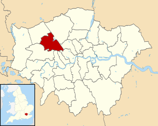
Alperton is an area of northwest London, England, in the London Borough of Brent. It is centred 7.5 miles (12 km) west north-west of Charing Cross. It includes a handful of high-rise and many mid-rise buildings as well as streets of low-rise houses with gardens. As with all of west London it is in the historic county of Middlesex. Adjoining the Grand Union Canal's Paddington Arm fed by the Brent Reservoir it forms the southern part of Wembley.

Harlesden is an area in the London Borough of Brent, northwest London. Its main focal point is the Jubilee Clock which commemorates Queen Victoria's Golden Jubilee. Harlesden has been praised for its vibrant Caribbean culture and unofficially named London's reggae capital. The population includes people of Afro-Caribbean heritage, as well as Irish, Portuguese, Brazilian and smaller Latin Americans and East African groups within the community.
Kilburn is an area of north-west London, England, situated 3.75 miles (6.0 km) north-west of Charing Cross. The main thoroughfare running northwest-southeast is Kilburn High Road, part of the modern A5 road, which forms the boundary between the boroughs of Brent and Camden and is in postcode NW6. On some definitions a small section is in the City of Westminster, with postcode W9. The road dates back to pre-Roman times and is part of the Roman road known as Watling Street. The town of Kilburn has its origins in a 12th-century priory on the banks of the Kilburn Brook. Kilburn today is a busy and multicultural London district. It has one of the capital's highest Irish populations, as well as a sizable Afro-Caribbean population. The area is identified in the London Plan as one of 35 major centres in Greater London.

Sandwell is a metropolitan borough of the West Midlands county in England. The borough is named after the Sandwell Priory, and spans a densely populated part of the West Midlands conurbation. According to Sandwell Metropolitan Borough Council, the borough comprises the six amalgamated towns of Oldbury, Rowley Regis, Smethwick, Tipton, Wednesbury, and West Bromwich, although these places consist of numerous smaller settlements and localities. Though West Bromwich is the largest town in the borough and its designated Strategic Town Centre, Sandwell Council House is situated in Oldbury.

Babergh is a local government district in Suffolk, England. Primarily a rural area, Babergh contains two towns of notable size: Sudbury, and Hadleigh, which was the administrative centre until 2017. Its council headquarters, which are shared with neighbouring Mid Suffolk, are now based in Ipswich.

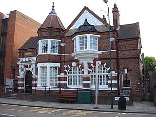
East Barnet is an area of north London within the London Borough of Barnet bordered by New Barnet, Cockfosters and Southgate. It is a largely residential suburb whose central area contains shops, public houses, restaurants and services, and the parish church of St Mary the Virgin. East Barnet is close to the M25 and the A1 and M1.

Brent North is a constituency represented in the House of Commons of the UK Parliament since 1997 by Barry Gardiner of the Labour Party, who became Shadow Secretary of State for International Trade in 2016.
Berrow is a small residential coastal village and holiday area, a civil parish in the Sedgemoor district of Somerset, England, situated in between Burnham-on-Sea and Brean.
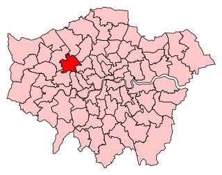
Brent Central is a constituency represented in the House of Commons of the UK Parliament. Created in 2010, it has been represented since 2015 by Dawn Butler of the Labour Party.

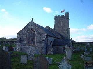
Brent Knoll, formerly known as South Brent, is a village and civil parish in Somerset, England, which lies on the southern edge of Brent Knoll – a hill with a height of 137 metres (450 ft) that dominates the low surrounding landscape of the Somerset Levels.

The Harrow Road is an ancient route in London which runs from Paddington in a northwesterly direction towards Harrow Middlesex. It is also the name given to the immediate surrounding area of Queens Park and Kensal Green, straddling the NW10, W10 and W9 postcodes. With minor deviations in the 19th and 20th centuries, the route remains otherwise unaltered. There are dozens of other existing roads throughout the United Kingdom using the same name which do not lead to or from Harrow but merely use the name of the town or, in some cases, a person of that name.

Stonebridge is a locality in the London Borough of Brent that forms the western part of Harlesden in north west London, England. It is also the name of the largest electoral ward in the borough, which includes Stonebridge itself as well as Park Royal, Brent Park and the St Raphael's Estate. It is the most populated ward in Brent with a population over 17,000 with the majority of Afro-Caribbean heritage.

Queensbury is an area of northwest London, England, in the southeast of the London Borough of Harrow on the boundary with the London Borough of Brent.

Brent Eleigh is a village and civil parish in the Babergh district of Suffolk, England. Located between Hadleigh and Lavenham, in 2005 it had a population of 180 reducing to 174 at the 2011 Census.

Tokyngton, also locally known as Monks Park, is a locality that forms the southeastern part of the town of Wembley in Greater London, in the London Borough of Brent, England. Most refer it as being either Wembley or Stonebridge, as the name Tokyngton is hardly used by locals and is not mentioned on street signs, except for street names and public places bearing the name. Today it covers part of the Harrow Road (A404) and the residential neighbourhood north of it.
Fryent Country Park together with Barn Hill Open Space is a large park situated in the north of the London Borough of Brent. It covers 103 hectares of rolling fields and small woods.
Preston ward is a political division of the London Borough of Brent that returns three representative councillors. At the 2006 election all 3 seats were held by the Conservatives, but Labour took 2 of the 3 seats at the 2010 election and won all 3 seats in 2014. The population of the ward at the 2011 Census was 15,484. The ward covers most of the area known as North Wembley.

Walsall Council, formerly Walsall Metropolitan Borough Council was created in 1974 to administer the newly formed Metropolitan Borough of Walsall.

The Papakura Local Board is one of the 21 local boards of the Auckland Council. It is overseen by the Manurewa-Papakura ward councillor.