
The Gletscherhorn is a mountain of the Bernese Alps, located on the border between the Swiss cantons of Bern and Valais. It forms the eastern edge of the Lauterbrunnen Wall, south of the Jungfrau.

The Grauspitz is a mountain in the Rätikon range of the Alps, located on the border between Liechtenstein and Switzerland. With an elevation of 2,599 metres (8,527 ft) above sea level, the Grauspitz is the highest mountain in Liechtenstein. It is also the highest summit of the Rätikon range west of the Schesaplana massif.
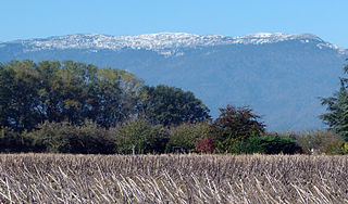
Le Crêt de la Neige is the highest peak in the Jura Mountains and the department of Ain in France. Its elevation is 1720 m above sea level. Its prominence is 1260 m. It is located in the commune of Thoiry.

The Strahlhorn is a mountain of the Swiss Pennine Alps, located south of Saas-Fee and east of Zermatt in the canton of Valais. It lies on the range that separates the Mattertal from the Saastal and is located approximately halfway between the Rimpfischhorn and the Schwarzberghorn.

The Chasseral is a mountain of the Jura Mountains, overlooking Lake Biel in the Swiss canton of Bern. With an elevation of 1,606 metres above sea level, the Chasseral is the highest summit in the canton of Bern outside the Alps. It is also both the northernmost and easternmost mountain reaching over 1,500 metres in the Jura Mountains. West of the summit is located the Chasseral Ouest, where runs the border with the canton of Neuchâtel. The Chasseral Pass is located further on the west.

The Irchel is an elevation in the Canton of Zürich, located at the Rhine between the Töss and Thur rivers, on the territory of Buch am Irchel, Berg am Irchel and Freienstein-Teufen, separating the Andelfingen and Bülach districts. It is an outlying ridge of the Jura, rising to 694 m, lying east of the Lägern. Historically, it was part of the Germanic Limes. The name is from a Helvetic word for "stag".

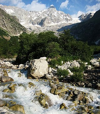
Le Portalet is a mountain of the Mont Blanc massif, located west of Praz de Fort in the canton of Valais. It lies on the range between the glaciers of Trient and Saleina. It has two important subsidiary summits: Grand Clocher du Portalet and Petit Clocher du Portalet. The latter forms a needle and is particularly hard to climb.

Tête de Valpelline is a mountain of the Pennine Alps, located on the Swiss-Italian border. It lies west of the Dent d'Hérens, between the valleys of Mattertal (Valais) and Valpelline.

The Aiguille du Tour is a mountain in the Mont Blanc massif, located on the border between Switzerland and France. The voie normale on the mountain is graded F (facile) and can be climbed from either the Albert Premier Hut on the French side or the Trient Hut on the Swiss side.

The Tour Noir is a mountain in the Mont Blanc massif on the Swiss-French border. It is located between the Aiguille d'Argentière and Mont Dolent.
The Pointe Allobrogia is a mountain of the Mont Blanc massif, overlooking the Col Ferret on the border between Italy and Switzerland. It lies at the southern end of the range south-east of Mont Dolent.
The Grande Lui is a mountain of the Mont Blanc massif, located west of La Fouly in the canton of Valais. It lies east of the Aiguille de l'A Neuve, on the range between the glaciers of Saleina and L'A Neuve.

The Grand Darray is a mountain of the Mont Blanc massif, located north of La Fouly in the canton of Valais. It lies on the range east of the Aiguille de l'A Neuve, between the Saleina Glacier and the main Ferret valley.
The Aiguille de l'A Neuve is a mountain of the Mont Blanc massif, located on the border between Switzerland and France. It lies close to the Tour Noir to the south.

Le Châtelet is a mountain of the Swiss Mont Blanc massif, overlooking Orsières in the canton of Valais. It lies between the valleys of Orny and Saleina.

The Wildspitz is the highest summit of the Rossberg, a mountain of the Schwyzer Alps, located on the border between the Swiss cantons of Zug and Schwyz. Reaching a height of 1,580 metres above sea level, it is the highest summit in the canton of Zug.

The Hage is a mountain in the Randen range between the Jura and the Swabian Jura, located between Beggingen and Merishausen in the Swiss canton of Schaffhausen. Reaching a height of 912 metres above sea level, it is the highest point of the canton.

The Hoher Randen 909 m (2,982 ft) with its Schlattersteig is the highest mountain of the Randen, a range located between the Jura and the Swabian Jura. It is located south of Blumberg in the German state of Baden-Württemberg, near the border with the Swiss canton of Schaffhausen.
The Dosse is a mountain of the Rigi massif, located on the border between the Swiss cantons of Lucerne and Schwyz. The mountain overlooks Lake Lucerne, near Vitznau. It is the highest point of the massif in the canton of Lucerne. The slightly lower peak only 200m northwest of it is called Chli Dosse.
Mont Vully is a hill of the Swiss Plateau, located between Lake Morat and Lake Neuchâtel in the canton of Fribourg, east of the border with the canton of Vaud.


 View from Sustenbrüggli (east side)