
Gloucester is a former municipality and now geographic area of Ottawa, Ontario, Canada. Located east of Ottawa's inner core, it was an independent city until amalgamated with the Regional Municipality of Ottawa–Carleton in 2001 to become the new city of Ottawa. The population of Gloucester is about 150,012 people.

Kanata is a suburb and former city within Ottawa, Ontario, Canada. It is located about 22 km (14 mi) west of the city's downtown core. As of 2021, the former City of Kanata had a population of 98,938, with the population centre having a population of 137,118. Before it was amalgamated into Ottawa in 2001, it was one of the fastest-growing cities in Canada and the fastest-growing community in Eastern Ontario. Located just to the west of the National Capital Commission Greenbelt, it is one of the largest of several communities that surround central Ottawa.

Nepean is an area of Ottawa, Ontario, Canada. Located west of Ottawa's inner core, it was an independent city until amalgamated with the Regional Municipality of Ottawa–Carleton in 2001 to become the new city of Ottawa. However, the name Nepean continues in common usage in reference to the area. The population of Nepean is about 186,593 people.

The Regional Municipality of Ottawa–Carleton was a Regional Municipality and Census Division in Ontario, Canada, that existed between January 1, 1969, and January 1, 2001, and was primarily centred on the City of Ottawa. It was created in 1969 by restructuring Carleton County and annexing Cumberland Township from the United Counties of Prescott and Russell into the newly created Region of Ottawa–Carleton.
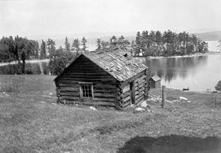
Goulbourn Township, Ontario, was formed in 1818, roughly 20 km southwest of downtown Ottawa, with the first major settlement occurring in Richmond. Other communities in the township include Stittsville, Munster, and Ashton. Stittsville is the largest community in the township, owing in part to its proximity to Kanata and the Queensway. The township was amalgamated into the current City of Ottawa in 2001.

Stittsville is a suburban community, part of the Canadian capital of Ottawa, Ontario. It is within the former Goulbourn Township. A part of the National Capital Region, Stittsville is immediately to the southwest of Kanata, adjacent to Richmond and about 20 km (12 mi) west of Downtown Ottawa. The urban part of the community corresponds to Stittsville Ward on Ottawa City Council and has been represented by Glen Gower since 2018. As of 2021, Stittsville ward had a population of 40,889.

Nepean—Carleton was a federal electoral district in Ontario, Canada that was represented in the House of Commons from 1979 to 1988, and again from 1997 to 2015.
Nepean Township is a former incorporated and now geographic township in Eastern Ontario, Canada, now part of the City of Ottawa.
March Township is a geographic township and former municipality originally part of Carleton County in eastern Ontario, Canada. It is currently part of the City of Ottawa. It is located in the western part of the county, bordered to the northwest by Torbolton Township, to the southwest by Huntley Township, to the east by Nepean, to the south by Goulbourn Township and to the north by the Ottawa River. According to the Canada 2001 Census, the Township had a population of approximately 26,650.

Huntley is a former incorporated and now geographic township in Carleton County in eastern Ontario, Canada.
Torbolton is a geographic township and former municipality that was originally part of Carleton County in eastern Ontario, Canada.
Fitzroy is a former incorporated and present day geographic township originally part of Carleton County in eastern Ontario, Canada.
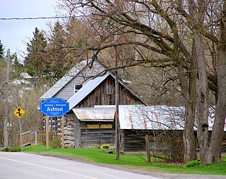
The small village of Ashton is located about 40 kilometres (25 mi) southwest of Downtown Ottawa, Ontario, at the intersection of Ashton Station Road and Flewellyn Road. Ashton Station Road runs through the centre of the community, and serves as the south-western boundary line for the City of Ottawa, thus making the eastern portion of the hamlet part of Ottawa, and the western portion part of Beckwith Township. The eastern portion of the community was originally part of Goulbourn Township, which was amalgamated into the City of Ottawa in 2001. It is home to approximately 200 residents.
Katimavik-Hazeldean is a neighbourhood in Kanata South Ward in the west end of Ottawa, Ontario, Canada. It is located in the former City of Kanata which amalgamated into Ottawa in 2001. It is located in south-central Kanata, bounded by Eagleson Road to the east, Hazeldean Road to the south, the Carp River to the west, and Highway 417 to the north.

Kanata—Carleton is a federal electoral district in Ottawa, Ontario.
Donald Baird "Don" Munro was a dairy farmer and politician in Ontario. He served as mayor of West Carleton Township, Ontario from 1974 to 1977 and from 1982 to 1984.

Carleton is a provincial riding in Ontario, Canada. It was created in 1867 at the time of confederation and lasted until provincial redistribution in 1996. In the 1999 provincial election it was redistributed into Nepean—Carleton and Lanark—Carleton. In 2007 it was abolished into Carleton—Mississippi Mills and Lanark—Frontenac—Lennox and Addington.
Kanata—Carleton is a provincial electoral district in Ottawa, Ontario which was first contested in the 2018 provincial election.