Cumberland, Ontario

Last updated

Cumberland
Former municipality
Cumberland Ottawa.JPG
Flag of Cumberland, Ontario.gif
Newottawamap.png
Map of City of Ottawa showing the former Cumberland Township and Cumberland Village.
Coordinates: 45°26′00″N75°26′02″W / 45.4332°N 75.4339°W / 45.4332; -75.4339
CountryCanada
Province Ontario
Municipality Ottawa
Established1800
Incorporated 1969 (township)
1999 (city)
Amalgamated 2001
Government
   Mayor Mark Sutcliffe
   City councillors Catherine Kitts
Matthew Luloff
   Members of Parliament Francis Drouin
   Members of Provincial Parliament Stéphane Sarrazin
Time zone UTC−5 (Eastern (EST))
  Summer (DST) UTC−4 (EDT)
Area code(s) 613, 343

Cumberland is a former municipality and now geographic township in eastern Ontario, Canada. It was an incorporated township from 1800 to 1999, when it was incorporated as the City of Cumberland, then ceased to be a separate municipality in 2001, when it was amalgamated into the city of Ottawa. It now exists only as a geographic township.

Contents

History

Cumberland, Ontario ward map 1997 Cumberland, Ontario ward map 1997.png
Cumberland, Ontario ward map 1997

Cumberland was originally incorporated as a township in 1800. It took its name from the Duke of Cumberland (later King of Hanover).

The township comprised the eastern portion of Ottawa's Orléans suburb as well as the communities of Cumberland Village, Carlsbad Springs, Navan, Notre-Dame-des-Champs, Sarsfield, and Vars.

Almost 200 years after it was first incorporated, Cumberland became a city in 1999. City status was short-lived however as the municipality was amalgamated with of Ottawa in 2001.

Cumberland now forms part of Ottawa. The largest portion of the former municipality now forms Orléans South-Navan Ward, previously named Cumberland Ward, and is represented at Ottawa City Council. Most of the suburban neighbourhood of Orléans, which straddled the former boundary between Cumberland and the city of Gloucester, has been split off from Cumberland and Gloucester and is now joined in Orléans East-Cumberland and Orléans West-Innes Wards. Thus, Orléans South-Navan Ward is now primarily rural in nature, made up of historic villages that now comprise bedroom communities of Ottawa.

Attractions

Cumberland Heritage Village Museum

The Cumberland Heritage Village Museum, which depicts rural life in a village setting during the 1920s and 1930s, celebrated its 35th anniversary on September 25, 2011. The museum features a General Store, one-room schoolhouse and antique vehicles at the village garage, a tractor-pulled wagon ride, and farm animals. The former Knox Presbyterian/United Church building (1904–1980) and its artefacts were relocated from Vars to the Cumberland Heritage Village Museum. A memorial Roll of Honor and plaque from the Knox Presbyterian Church are dedicated to its members who served and to those who gave their lives in the First World War. [1] [2] A memorial scroll from the Knox Presbyterian Church is dedicated to its members who served in the Second World War. [3]

Every other Sunday, the Ottawa Valley Live Steamers and Model Engineers are on site to give rides on their model trains. The museum has a collection of over 20,000 artifacts, including ceramic, textile and agricultural equipment, many of which have never been on display. The museum and artifact collection were included amongst other architecturally interesting and historically significant buildings in Doors Open Ottawa in 2012. [4]

Other attractions

A memorial stands in front of St. Andrews United Church, dedicated to soldiers who lost their lives during the First and Second World Wars, as well as the Korean War. [5]

In 2017, Dr. Ranjit Pereira opened Humanics Sanctuary and Sculpture Park, a non-commercial art object dedicated to representation of world religions, cults and ethical teaching. [6]

Population breakdown

See also

Related Research Articles

<span class="mw-page-title-main">Orléans (federal electoral district)</span> Federal electoral district in Ontario, Canada

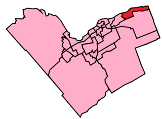
Orléans is a federal electoral district in Ottawa, Ontario, Canada, that has been represented in the House of Commons of Canada since 1988.

<span class="mw-page-title-main">Orleans, Ontario</span> Suburb of Ottawa, Ontario, Canada

Orleans is a community in Ottawa, Ontario, Canada. It is located in the east end of the city along the Ottawa River, about 16 km (10 mi) from Downtown Ottawa. The Canada 2021 Census determined that Orléans' population was 125,937. Before being amalgamated into Ottawa in 2001, the community of Orléans was spread over two municipal jurisdictions, the eastern portion being in the pre-amalgamation City of Cumberland, the western portion in the City of Gloucester. According to the 2021 census, 75,453 people lived in the Cumberland portion of Orleans, while 50,484 lived in the Gloucester portion. Today, Orléans spans the municipal wards of Orléans East-Cumberland, Orléans West-Innes, and Orléans South-Navan. Orléans contains a significant francophone population.

<span class="mw-page-title-main">St. Andrew's Presbyterian Church (Ottawa)</span> Presbyterian church in Ottawa, Ontario, Canada

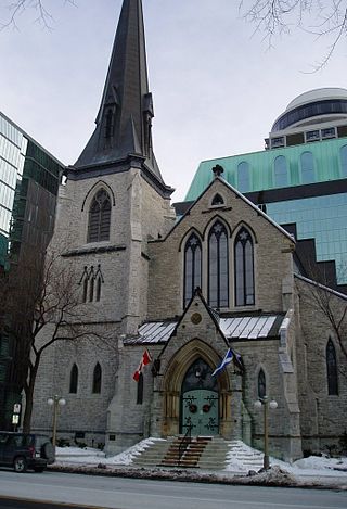
St. Andrew's Presbyterian Church is the oldest Presbyterian church in Ottawa, Ontario, Canada.

<span class="mw-page-title-main">Knox Presbyterian Church (Ottawa)</span> Church in Ontario, Canada

Knox Presbyterian Church is a Presbyterian Church in Ottawa, Ontario, Canada. It is named after John Knox, a founder of Presbyterianism in Scotland.

<span class="mw-page-title-main">Glengarry—Prescott—Russell (federal electoral district)</span> Federal electoral district in Ontario, Canada

Glengarry—Prescott—Russell is a federal electoral district in Ontario, Canada, that has been represented in the House of Commons of Canada since 1953.

Trim Road is an arterial road in the eastern end of Orléans, Ontario, a suburb of Ottawa. It serves as the only road access to Petrie Island and its public beach in the Ottawa River. From Petrie Island, Trim runs south through the eastern suburban areas of Orleans and then south into rural former Cumberland Township. It travels through the community of Navan before ending at Perreault Road. It has a total length of 14.4 km (8.9 mi) and connects with Ottawa Regional Road 174 that connects with Highway 417 further to the west. Its status as a numbered road in Ottawa's city road status ends at Innes Road on the south side of Orleans.

<span class="mw-page-title-main">Orléans East-Cumberland Ward</span> Place in Ontario, Canada

Orléans East-Cumberland Ward is a city ward in the city of Ottawa, Ontario, Canada, represented on Ottawa City Council. It was created before the 2000 Election when the area was amalgamated into the city of Ottawa. The ward covers much of the suburban community of Orleans in the east of the city. Previous to that, the ward existed in the Regional Municipality of Ottawa-Carleton Council. It contains the neighbourhoods of Queenswood Heights, Queenswood Village, Fallingbrook, Cardinal Creek, Cardinal Creek Village, Bella Vista and Cumberland Village.

<span class="mw-page-title-main">North Gower</span> Community in Ontario, Canada

North Gower is a small village in eastern Ontario, originally part of North Gower Township, now part of the city of Ottawa. Surrounding communities include Richmond, Kemptville, Kars and Manotick. Public high school students in this area go to South Carleton High School in Richmond. Elementary school students go to Marlborough Public School in North Gower.

<span class="mw-page-title-main">Bob Monette</span> Canadian politician

Robert "Bob" Monette is a politician in Ottawa, Ontario, Canada. He first joined political life in 1985 when he served on the Cumberland City Council for six years. Monette returned to serve on the Ottawa City Council in January 2006 in a by-election and was then reelected in November 2006 and October 2010.

<span class="mw-page-title-main">Montreal Road</span>

Montreal Road, also known as Ottawa Road #34, is a major east-west Ottawa road that links Lowertown to Vanier and the farther eastern neighbourhoods of Ottawa. Until downloading in 1998, it was part of the provincially managed Highway 17B.

<span class="mw-page-title-main">Fallingbrook, Ottawa</span>

Fallingbrook is a neighbourhood in the community of Orleans, a suburb in the city of Ottawa, Ontario, Canada. It is located on the east edge of Orleans and is bounded by Tenth Line Road in the west, St. Joseph Boulevard to the north, Trim Road to the east and Innes Road to the south. Below the community of Fallingbrook flows the Ottawa River, and Petrie Island is the closest beach.

<span class="mw-page-title-main">Sarsfield, Ontario</span>

Sarsfield, Ontario is a village in Cumberland Ward in the east portion of the City of Ottawa in the former township of Cumberland.

<span class="mw-page-title-main">Orléans South-Navan Ward</span> Place in Ontario, Canada

Orléans South-Navan Ward is a city ward in Ottawa, Ontario represented on Ottawa City Council. It is located in the east end of the city, encompassing the southern portion of the Orleans subdivision and surrounding rural areas.

<span class="mw-page-title-main">Navan, Ontario</span> Neighbourhood of Ottawa

Navan is a community in Orléans South-Navan Ward in Ottawa, Ontario, Canada. It is located southeast of the suburban community of Orleans.

Queenswood Heights is a neighbourhood located in Orleans, the suburb in the east end of Ottawa, Ontario, Canada. Prior to amalgamation in 2001, the neighbourhood was in the Township of Cumberland. Queenswood Heights is bounded by St. Joseph Boulevard to the north, Tenth Line Road to the east, Innes Road to the south, and the former Cumberland-Gloucester boundary to the west (the Queenswood Heights Community Association considers Duford St. to be the western boundary). According to the Canada 2016 Census, the population of the neighbourhood was 11,031. Queenswood Heights spans 3.71 square kilometres.

Vernon is a compact rural community in Osgoode Ward in the southern part of the city of Ottawa, Ontario, Canada. Prior to amalgamation in 2001, Vernon was located in Osgoode Township.

CJRO-FM is a radio station which broadcasts a community radio format on the frequency 107.7 FM (MHz) in Carlsbad Springs, Ontario, Canada.

<span class="mw-page-title-main">Bearbrook, Ontario</span> Dispersed rural community in Ontario, Canada

Bearbrook is a dispersed rural community in Cumberland Ward in the city of Ottawa, Ontario, Canada. It is named after the nearby small creek Bear Brook, a tributary of the South Nation River.

References

  1. "Knox Presbyterian Church memorial plaque (First World War): Cumberland Heritage Village Museum: Memorial 35024-004 Ottawa (Cumberland), ON". National Inventory of Canadian Military Memorials. Veterans Affairs Canada . Retrieved 8 January 2017.
  2. "Knox Presbyterian Church roll of honour (First World War): Cumberland Heritage Village Museum: Memorial 35024-005 Ottawa (Cumberland), ON". National Inventory of Canadian Military Memorials. Veterans Affairs Canada . Retrieved 8 January 2017.
  3. "Knox Presbyterian Church roll of honour (Second World War): Cumberland Heritage Village Museum: Memorial 35024-007 Ottawa (Cumberland), ON". National Inventory of Canadian Military Memorials. Veterans Affairs Canada . Retrieved 8 January 2017.
  4. "2012 Buildings." Archived 2012-05-26 at the Wayback Machine Doors Open Ottawa. Retrieved: May 27, 2012.
  5. "Cumberland war memorial: Memorial 35024-020 Ottawa (Cumberland), ON". National Inventory of Canadian Military Memorials. Veterans Affairs Canada . Retrieved 8 January 2017.
  6. "About Us".
  7. (Dissemination Areas 35060001, 35060002, 35060003, 35060005, 35060006)
  8. (Dissemination Areas 35060007, 35061113, 35061114, 35061115, 35061116, 35061117, 35061118)
  9. (Dissemination Areas 35061119, 35061120, 35061121)
  10. (Dissemination Areas 35061122, 35061123, 35061124)
  11. (Census Tracts 50500171.07, 50500171.09, 50500171.10)
  12. (Census Tract 50500170.01)
  13. (Census Tract 50500171.05)
  14. (Census Tracts 50500170.08, 50500170.09, 50500170.10, 50500170.11, 50500170.12, 50500170.13)
  15. (Census Tracts 50500170.03, 50500170.04, 50500170.05)
Bibliography