
Mount St. Helens is an active stratovolcano located in Skamania County, Washington, in the Pacific Northwest region of the United States. It lies 52 miles (83 km) northeast of Portland, Oregon, and 98 miles (158 km) south of Seattle. Mount St. Helens takes its English name from that of the British diplomat Alleyne Fitzherbert, 1st Baron St Helens, a friend of explorer George Vancouver who surveyed the area in the late 18th century. The volcano is part of the Cascade Volcanic Arc, a segment of the Pacific Ring of Fire.

Half Dome is a quartz monzonite batholith at the eastern end of Yosemite Valley in Yosemite National Park, California. It is a well-known rock formation in the park, named for its distinct shape. One side is a sheer face while the other three sides are smooth and round, making it appear like a dome cut in half. It stands at nearly 8,800 feet above sea level and is composed of quartz monzonite, an igneous rock that solidified several thousand feet within the Earth. At its core are the remains of a magma chamber that cooled slowly and crystallized beneath the Earth's surface. The solidified magma chamber was then exposed and cut in half by erosion, therefore leading to the geographic name Half Dome.

Tuolumne Meadows is a gentle, dome-studded, sub-alpine meadow area along the Tuolumne River in the eastern section of Yosemite National Park in the United States. Its approximate location is 37°52.5′N119°21′W. Its approximate elevation is 8,619 feet (2,627 m). The term Tuolumne Meadows is also often used to describe a large portion of the Yosemite high country around the meadows, especially in context of rock climbing.
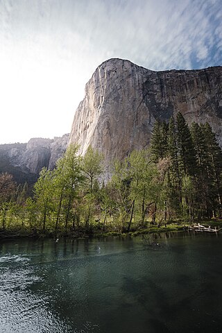
El Capitan is a vertical rock formation in Yosemite National Park, on the north side of Yosemite Valley, near its western end. The granite monolith is about 3,000 feet (914 m) from base to summit along its tallest face and is a world-famous location for big wall climbing, including the disciplines of aid climbing, free climbing, and more recently for free solo climbing.

Lembert Dome is a granite dome rock formation in Yosemite National Park in the US state of California. The dome soars 800 feet (240 m) above Tuolumne Meadows and the Tuolumne River and can be hiked starting at the Tioga Road in the heart of Tuolumne Meadows, 8 miles (13 km) west of the Tioga Pass Entrance to Yosemite National Park. The landform is an example of a rôche moutonnée with clear lee and stoss slopes.

The Aiguille de Bionnassay is a mountain in the Mont Blanc massif of the Alps in France and Italy. It has been described as "one of the most attractive satellite peaks of Mont Blanc", and is located on its western side. The mountain's south and east ridges form the frontier between the two countries, and its summit is a knife-edge crest of snow and ice. Reaching it via any route provides a "splendid and serious snow and ice climb".

Warren Harding was one of the most accomplished and influential American big wall climbers and aid climbers of the 1950s to 1970s. He was the leader of the first team to climb El Capitan, Yosemite Valley, in 1958. The route they climbed, known as The Nose, ascends 2,900 feet (880 m) up the central buttress of what is one of the largest granite monoliths in the world. Harding made many first ascents in Yosemite, some 28 in all, including The Wall of Early Morning Life.

The Barre des Écrins is a mountain in the French Alps with a peak elevation of 4,102 metres (13,458 ft). It is the highest peak of the Massif des Écrins and the Dauphiné Alps and the most southerly alpine peak in Europe that is higher than 4,000 metres. It is the only 4,000-metre mountain in France that lies outside the Mont Blanc Massif. Before the annexation of Savoy in 1860 it was the highest mountain in France.

The Dragoon Mountains is a range of mountains located in Cochise County, Arizona. The range is about 25 mi (40 km) long, running on an axis extending south-south east through Willcox. The name originates from the 3rd U.S. Cavalry Dragoons who battled the Chiricahua, including Cochise, during the Apache Wars. The Dragoons established posts around 1856 after the Gadsden Purchase made it a U.S. territory.

The Gap of Dunloe, also recorded as Bearna an Choimín, is a narrow mountain pass running north–south in County Kerry, Ireland, that separates the MacGillycuddy's Reeks mountain range in the west, from the Purple Mountain Group range in the east. It is one of Kerry's most popular tourist destinations on account of its scenery.

Purple Mountain at 832 metres (2,730 ft) high, is the 21st–highest peak in Ireland on the Arderin scale, and the 28th–highest according to the Vandeleur-Lynam scale. It is located in County Kerry, and is the highest point of the Purple Mountain Group.

The Nose is a big wall climbing route up El Capitan. Once considered impossible to climb, El Capitan is now the standard for big wall climbing. It is recognized in the historic climbing text Fifty Classic Climbs of North America and considered a classic around the world.
Pywiack Dome is a prominent 600 foot granite dome in Yosemite National Park, located 0.7 miles (1.1 km) north-east of Tenaya Lake, 4 miles (6.4 km) west of Tuolumne Meadows and 200 feet (61.0 m) from the Tioga Road. It is quite near Harlequin Dome, and North and South Whizz Domes are north.

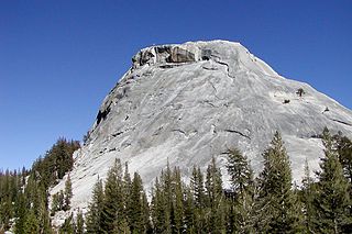
Daff Dome or DAFF Dome is a prominent 800 feet (243.8 m) granite dome in Yosemite National Park, 3 miles (4.8 km) west of Tuolumne Meadows and 1,700 feet (0.5 km) from the Tioga Road. It is southeast of Doda Dome, and is near both West Cottage Dome and East Cottage Dome; it is also near Lamb Dome. Since the dome was never officially named, the DAFF Dome name was adopted in the 1960s as an acronym of "Dome Across From Fairview" Dome.

Medlicott Dome is a prominent granite dome in Yosemite high country. It is located on the southeast side of Tioga Road, between Mariolumne Dome and Dozier Dome, near Pywiack Dome, the Cathedral lakes, Drug Dome, East Cottage Dome, West Cottage Dome, North and South Whizz Domes, and Fairview Dome. It is popular with climbers, hikers and backpackers due to relative ease of access and ascent, as well as scenic views of Yosemite.
Hiking, rock climbing, and mountain climbing around Tuolumne Meadows in Yosemite National Park has many options.
Drug Dome is a granite dome in the Tuolumne Meadows area of Yosemite National Park. Drug Dome is just west of Fairview Dome. It is also near Mariolumne Dome, Lamb Dome and Medlicott Dome.
East Cottage Dome, also, Erratic Dome, is a granite dome in the Tuolumne Meadows area of Yosemite National Park.
Hammer Dome, is a granite dome in the Tuolumne Meadows area of Yosemite National Park. Hammer Dome is a bit north, of Cathedral Creek, which has its source, near Cathedral Peak. Hammer Dome is loosely northwest of Fairview Dome, is north of both Medlicott Dome and Pywiack Dome, all three of which are south of California State Route 120, which runs through Tuolumne Meadows to Tioga Pass. North and South Whizz Domes are close.

West Quarter Dome is a granodiorite dome, in the Tenaya Canyon area of Yosemite National Park. It is composed of Half Dome Granodiorite.

