
The Metropolitan Police Service (MPS), formerly and still commonly known as the Metropolitan Police, is the territorial police force responsible for law enforcement and crime prevention within Greater London. In addition, it is responsible for specialised tasks throughout the United Kingdom, such as dealing with counter-terrorism throughout the UK, and the protection of certain individuals, including the monarch, royal family, governmental officials, and other designated figures. Commonly referred to as the Met, it is also referred to as Scotland Yard or the Yard, after the location of its original headquarters in Great Scotland Yard, Whitehall in the 19th century. The Met is presently headquartered at New Scotland Yard, on the Victoria Embankment.

Calderdale is a metropolitan borough of West Yorkshire, England, which had a population of 211,439. It takes its name from the River Calder, and dale, a word for valley. The name Calderdale usually refers to the borough through which the upper river flows, while the actual landform is known as the Calder Valley. Several small valleys contain tributaries of the River Calder. The main towns of the borough are Brighouse, Elland, Halifax, Hebden Bridge, Sowerby Bridge and Todmorden.

Sir James Wilson Vincent Savile was an English media personality and DJ. Savile was well known in the United Kingdom for his eccentric image, charitable work, and hosting the BBC shows Top of the Pops, a pop music programme, and the popular children's programme, Jim'll Fix It. After his death, hundreds of allegations of sexual abuse made against him were investigated, leading the police to conclude that he had been a predatory sex offender and possibly one of Britain's most prolific. There had been allegations during his lifetime, but they were dismissed and accusers were ignored or disbelieved.

Downtown Los Angeles (DTLA) is the central business district of the city of Los Angeles. It is part of the Central Los Angeles region and covers a 5.84 sq mi (15.1 km2) area. As of 2020, it contains over 500,000 jobs and has a population of roughly 85,000 residents, with an estimated daytime population of over 200,000 people prior to the COVID-19 pandemic.

Savile Row is a street in Mayfair, central London. Known principally for its traditional bespoke tailoring for men, the street has had a varied history that has included accommodating the headquarters of the Royal Geographical Society at 1 Savile Row, where significant British explorations to Africa and the South Pole were planned; and more recently, the Apple office of the Beatles at 3 Savile Row, where the band's final live performance was held on the roof of the building.
Spencer Street is a major street and thoroughfare in the Melbourne central business district, Victoria, Australia. The street was gazetted in 1837 as the westernmost boundary of the Hoddle Grid.

The Greater Dublin Area, or simply Greater Dublin, is an informal term that is taken to include the city of Dublin and its hinterland, with varying definitions as to its extent. At the expansive end, it has been defined as including all of the traditional County Dublin and three neighbouring counties, while more commonly it is taken as the contiguous metropolitan area of Dublin plus suburban and commuter towns. The area is defined for strategic planning, and, for example, transport, and it is not a formal administrative or political unit.

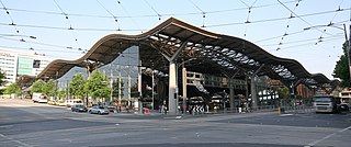
Stockport railway station serves the large market and industrial town of Stockport in Greater Manchester, England. It is located 6 miles south-east of Manchester Piccadilly, on a spur of the West Coast Main Line to London Euston.

West Yorkshire Police, formerly the West Yorkshire Metropolitan Police, is the territorial police force responsible for policing the metropolitan county of West Yorkshire, England. It is the fourth largest territorial police force in England and Wales by number of officers.

Taltala is a neighbourhood in Central Kolkata, in Kolkata district in the Indian state of West Bengal. One of the oldest neighbourhoods of the metropolis, it has a police station on its own name.

Halifax is a town in the Metropolitan Borough of Calderdale, in West Yorkshire, England. It is in the eastern foothills of the Pennines. In the 15th century, the town became an economic hub of the old West Riding of Yorkshire, primarily in woollen manufacture with the large Piece Hall square later built for trading wool in the town centre. The town was a thriving mill town during the Industrial Revolution with the Dean Clough Mill buildings a surviving landmark. In 2021, it had a population of 88,109. It is also the administrative centre of the wider Calderdale Metropolitan Borough.
The history of the Metropolitan Police in London is long and complex, with many different events taking place between its inception in 1829 and the present day.

The London Borough of Camden is a borough in Inner London, England. Camden Town Hall, on Euston Road, lies 1.4 mi (2.3 km) north of Charing Cross. The borough was established on 1 April 1965 from the former metropolitan boroughs of Holborn, St Pancras and Hampstead.

Franklin Street is a main street in the Adelaide city centre, South Australia.

Richard James is a bespoke Savile Row tailors and contemporary menswear company. It was founded in 1992 by designer Richard James, a graduate of Brighton College of Art and a former buyer for the London boutique Browns, and his business partner Sean Dixon. The Design and Brand Director is Toby Lamb, a graduate of Central Saint Martins. Richard James has won both the British Fashion Council's Menswear Designer of the Year and Bespoke Designer of the Year awards.

Savile Row tailoring is men and women's bespoke tailoring that takes place on Savile Row and neighbouring streets in Mayfair, Central London. In 1846, Henry Poole, credited as being the "Founder of Savile Row", opened an entrance to his tailoring premises at No. 32 Savile Row. The term bespoke is understood to have originated in Savile Row when cloth for a suit was said to "be spoken for" by individual customers. The short street has been termed the "golden mile of tailoring", where customers have included Charles III, Winston Churchill, Lord Nelson, Napoleon III, Muhammad Ali Jinnah, Laurence Olivier and Duke Ellington.

Fortress House was a building with its main entrance at 23 Savile Row in London W1, also including 5–9 New Burlington Street. It was built in 1949–50 to a design by Anthony Lloyd, and demolished in 2009.

Boyle Street is a short street in central London that is named after the Boyles, the Earls of Burlington, and is on land that was once part of the Burlington Estate.

Vine Street Police Station was a Metropolitan Police station at No. 10 Vine Street in central London.

