West Fork Complex

Last updated
West Fork Complex
WestForkFireComplexCloseup61913.jpg
Southern Colorado, United States
Coordinates 37°22′24″N107°00′11″W / 37.373431°N 107.002931°W / 37.373431; -107.002931 Coordinates: 37°22′24″N107°00′11″W / 37.373431°N 107.002931°W / 37.373431; -107.002931
Statistics [1]
Date(s)June 5, 2013 (2013-06-05) – November 13, 2013 (2013-11-13)
Burned area109,615 acres (444 km2)
Cause Lightning
Map
USA Colorado location map.svg
FireIcon.svg

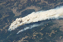
The West Fork Complex was a complex of wildfires near Wolf Creek Pass in southern Colorado. [2] The first fire, the West Fork fire, was started by lightning at about 1 PM on June 5, 2013. All three fires were started by lightning. As the fire moved into heavy dead timber in early June, thousands of firefighters struggled to prevent movement of the fires into populated areas. [1]

Contents

It was composed of the West Fork fire, northeast of Pagosa Springs, Colorado, south of Wagon Wheel Gap, and southwest of South Fork, Colorado; the Papoose fire south of Creede, Colorado; and the small Windy Pass fire, near the Wolf Creek ski area. As of the afternoon of July 8:

Much of the complex was in the Weminuche Wilderness but has burned into surrounding areas in the San Juan and Rio Grande National Forests and private land. The fires, particularly the West Fork fire, burned in dead trees killed by the spruce beetle. Due to the intensity of the West Fork fire which for some days was burning in windy conditions no attempt was made to directly attack it. Aggressive, and so far successful, efforts were made to prevent the Windy Pass fire from reaching the ski area. South Fork and Wagon Wheel Gap were evacuated and U.S. Highway 160 and State Highway 149 were closed to the west of South Fork. Route 160 was reopened at 6 AM June 29; Route 149 was reopened June 30. Most personnel were engaged in structure protection efforts to the west of South Fork, on the low terrain near the Rio Grande River to the north of the fires, and at tourist facilities south of Creede. [1] [3] On the 19th of July when the last incident update was made the fires had a total area of 109,615 acres and were 66% contained with 43 personnel engaged in combating them; the fire was described as "smoldering." There are two incident command posts, one in Pagosa Springs, Colorado for the portion of the fire on the west side of the Continental Divide, the other in Del Norte, Colorado for the portion on the east side. As of July 8 the portion of the West Fork fire west of the Continental Divide remained at 0% containment while the portion east of the Continental Divide was 25%. [1]

There was about .20 of an inch of precipitation on some parts of the fire June 30 due to a thunderstorm, but strong and erratic winds also stimulated the fire. On July 4, 2013 the fires were described as "creeping and smoldering" with fire suppression efforts being directed at preventing the expansion of the fire into heavy stands of dead and down fuel. Growth of the fire had continued on the southeastern side of the Papoose fire but as of July 8 widespread showers had moderated fire behavior. As of July 14 humidity was gradually increasing as the monsoon season approached with occasional thunderstorms expected and flash flood warnings issued for the area. As of July 19 precipitation had considerably dampened the fire, but smoldering and smoke continued. [1]

Final map of the West Fork Complex July 13, 2013 WestForkComplexMapFinal.jpg
Final map of the West Fork Complex July 13, 2013
Smoke plume near Big Meadows Campground SmokePlumeWestForkComplex.jpg
Smoke plume near Big Meadows Campground

See also

Related Research Articles

<span class="mw-page-title-main">2012 Colorado wildfires</span>

The 2012 Colorado wildfires were an unusually devastating series of Colorado wildfires, including several separate fires that occurred throughout June, July, and August 2012. At least 34,500 residents were evacuated in June.

<span class="mw-page-title-main">2012 Washington wildfires</span>

The 2012 Washington wildfires were a series of 1,342 wildfires that burned 259,526 acres (1,050 km2) over the course of 2012. The fires primarily occurred in the Okanogan and Wenatchee National Forests during September and October 2012. A severe lightning storm on September 8 caused hundreds of fires across the east side of Cascade Range. Smoke caused hazardous air quality conditions in the cities of Ellensburg and Wenatchee, and was noticeable in Seattle. The cost of fighting the largest four fires was estimated to be $67.5 million.

<span class="mw-page-title-main">2013 Colorado wildfires</span>

In the summer of 2013, there were several major wildfires in Colorado in the United States. During June and July, record high temperatures and dry conditions fueled the fires all across the state. By July 24, 570 structures had been destroyed and 2 people died. Below is a list of the major fires of the year.

<span class="mw-page-title-main">2014 Washington wildfires</span>

The 2014 Washington wildfires were a series of 1,480 wildfires that burned 386,972 acres (1,566 km2) over the course of 2014. The first occurred primarily on the east side of the Cascade Range in Chelan and Okanogan counties. The fires burned private land, state land, and within the Okanogan and Wenatchee National Forests, ultimately covering over 350,000 acres. The first fire began on July 8 near the Entiat River. On July 14 a lightning storm started dozens more fires across the eastern Cascade Range. Governor Jay Inslee declared a state of emergency, activating the Washington National Guard. More lightning strikes later in the summer started additional fires.

<span class="mw-page-title-main">Georges Fire</span>

The Georges Fire was a wildfire in Inyo County, California in the United States. The fire was reported on July 8, 2018 in a rural area north of Lone Pine and west of Manzanar. The fire was started by a lightning strike and impacted recreational activities in the Inyo National Forest, as well as the habitat for Sierra Nevada bighorn sheep, an endangered species. The fire burned 2,883 acres (12 km2), before burning out on July 18.

<span class="mw-page-title-main">Valley Fire (2018)</span> 2018 wildfire in California

The Valley Fire was a wildfire that burned near the community of Forest Falls in San Bernardino National Forest, including the San Gorgonio Wilderness in California, United States. The fire was reported on July 6, one of a handful of brush fires that started in the area due to high temperatures and dry conditions. The Valley Fire burned 1,350 acres (5 km2) before it was fully contained on October 22. The fire impacted traffic on Highway 38 due to road closures and has caused evacuations of Forest Falls.

<span class="mw-page-title-main">Mendocino Complex Fire</span> 2018 wildfire in California

The Mendocino Complex Fire was a large complex of wildfires that burned in northern California for more than three months in 2018. It consisted of two wildfires, the River Fire and Ranch Fire, which burned in Mendocino, Lake, Colusa, and Glenn Counties in the U.S. State of California, with the Ranch Fire being California's single-largest recorded wildfire at the time until the Dixie Fire in 2021. The Ranch Fire burned eight miles northeast of Ukiah, and the River Fire burned six miles north of Hopland, to the south of the larger Ranch Fire. First reported on July 27, 2018, both fires burned a combined total of 459,123 acres (1,858 km2), before they were collectively 100% contained on September 18, though hotspots persisted until the complex was fully brought under control on January 4, 2019. The Ranch Fire alone burned 410,203 acres (1,660 km2), making it the largest wildfire in modern California history at the time until the August Complex fire that occurred in 2020. The Ranch Fire also surpassed the size of the 315,577-acre Rush Fire, which burned across California and Nevada, as well as the Santiago Canyon Fire of 1889, which was previously believed to have been California's all-time largest wildfire.

<span class="mw-page-title-main">South Fire</span>

The South Fire was a wildfire that burned on the southeast side of Tomhead Mountain in Shasta-Trinity National Forest in Tehama County, California in the United States. The fire was started by a lightning strike, making it one of 26 reported fires in the area due to thunderstorm. On October 17, the fire had burned 5,332 acres (2,158 ha) and was 75 percent contained. Select trails and roads in the fire area were closed.

<span class="mw-page-title-main">Lime Fire</span>

The Lime Fire was a wildfire located west of Interstate 5 and north of Highway 96 in the Klamath National Forest's Lime Gulch area in Siskiyou County. The fire was started as the result of a lightning strike during a thunderstorm. As of September 17, the fire has burned 1,862 acres (754 ha) and is 96 percent contained. Evacuation warnings are in place for the area between Ash Creek and Gottsville, warning to take "extreme caution" along Highway 96. Portions of Klamath National Forest are closed due to the fire.

<span class="mw-page-title-main">Pine Gulch Fire</span>

The Pine Gulch Fire was a wildfire that burned in Mesa County and Garfield County, Colorado in the United States. The fire was started by a lightning strike and first reported on July 31, 2020 and quickly grew, resulting in the fire being named the largest wildfire in Colorado history, surpassing the 2002 Hayman Fire. Almost seven weeks later, it was surpassed by the Cameron Peak Fire in Larimer County.

<span class="mw-page-title-main">Grizzly Creek Fire</span>

The Grizzly Creek Fire was a wildfire that burned 32,631 acres in Glenwood Canyon in the state of Colorado in the United States. The fire first ignited on August 10, 2020 and was declared 100% contained on December 18, 2020. The Grizzly Creek fire's proximity to Interstate 70 resulted in a 13-day closure of the interstate. It threatened the Shoshone Generating Station and resulted in the evacuation of residences in the area, as well as closure of recreational land in portions of White River National Forest. The fire was ruled to be human-caused.

<span class="mw-page-title-main">August Complex fire</span> 2020 wildfire in California

The August Complex was a massive wildfire that burned in the Coast Range of Northern California, in Glenn, Lake, Mendocino, Tehama, Trinity, and Shasta Counties. The complex originated as 38 separate fires started by lightning strikes on August 16–17, 2020. Four of the largest fires, the Doe, Tatham, Glade, and Hull fires, had burned together by August 30. On September 9, the Doe Fire, the main fire of the August Complex, surpassed the 2018 Mendocino Complex to become both the single-largest wildfire and the largest fire complex in recorded California history. On September 10, the combined Doe Fire also merged with the Elkhorn Fire and the Hopkins Fire, growing substantially in size. By the time it was extinguished on November 12, the August Complex fire had burned a total of 1,032,648 acres (417,898 ha), or 1,614 square miles (4,180 km2), about 1% of California's 100 million acres of land, an area larger than the state of Rhode Island.

<span class="mw-page-title-main">North Complex Fire</span> A large complex wildfire in Northern California in 2020

The North Complex Fire was a massive wildfire complex that burned in the Plumas National Forest in Northern California in the counties of Plumas and Butte. 21 fires were started by lightning on August 17, 2020; by September 5, all the individual fires had been put out with the exception of the Claremont and Bear Fires, which merged on that date, and the Sheep Fire, which was then designated a separate incident. On September 8, strong winds caused the Bear/Claremont Fire to explode in size, rapidly spreading to the southwest. On September 8, 2020, the towns of Berry Creek and Feather Falls were immediately evacuated at 3:15 PM PDT with no prior warning, By September 9, 2020, the towns of Berry Creek and Feather Falls had been leveled, with few homes left standing. The fire threatened the city of Oroville, before its westward spread was stopped. The fire killed 16 people and injured more than 100. Among the 16 fatalities was a 16-year-old boy. The complex burned an estimated 318,935 acres (129,068 ha), and was 100% contained on December 3. The fire was managed by the U.S. Forest Service in conjunction with Cal Fire, with the primary incident base in Quincy. The North Complex Fire was the sixth-largest in California's modern history, and the deadliest fire in the 2020 California wildfire season.

<span class="mw-page-title-main">Santiam Fire</span> 2020 Oregon wildfire

The Santiam Fire was a very large wildfire that burned in Marion, Jefferson, Linn, and Clackamas Counties, in northwest Oregon, United States. Having ignited in August of 2020, the 402,274-acre (162,795 ha) fire ravaged multiple communities in northwestern Oregon, before it was fully contained on December 10, 2020. The fire started as three separate fires. The Beachie Creek, Lionshead, and P-515 fires were ignited by lightning on August 16, 2020. The first three fires gradually grew in size, before explosively spreading in early September during a heatwave, fanned by powerful east winds. Early on September 8, the Beachie Creek and Lionshead Fires merged, and the combined fire was labeled the Santiam Fire, before being returned to their original names a couple of days later. The P-515 Fire merged into the Lionshead Fire a few days later. The Santiam Fire destroyed over 1,500 structures, including the cities of Detroit and Gates, with Idanha, Mill City, and Lyons suffering varying amounts of damage, becoming one of the most destructive wildfires in the recorded history of Oregon. The fire killed five people. On September 10–12, 2020, there were fears that the Santiam Fire would merge with the Riverside Fire to the north.

<span class="mw-page-title-main">SQF Complex</span> 2020 wildfire that burnt in Tulare County, California

SQF Complex or Sequoia Complex was a complex of two of the August 2020 California lightning wildfires, burning in Sequoia National Forest and adjacent areas. Sparked on August 19, it included the Castle and Shotgun fires. As of January 5, 2021, it had burned 174,178 acres (70,487 ha) and was 100% contained. 228 structures were destroyed.

<span class="mw-page-title-main">2020 Colorado wildfires</span>

The 2020 Colorado wildfire season was a series of significant wildfires that burned throughout the U.S. state of Colorado as part of the 2020 Western United States wildfire season. With a total of 665,454 acres (269,300 ha) burned, it is Colorado's largest wildfire season on record.

<span class="mw-page-title-main">Tamarack Fire</span> 2021 wildfire in California and Nevada

The Tamarack Fire was a wildfire that burned 68,637 acres (27,776 ha), primarily in the Mokelumne Wilderness in Alpine County, California, Douglas County, Nevada and Lyon County, Nevada, as part of the 2021 California wildfire season.

<span class="mw-page-title-main">Beckwourth Complex fires</span> 2021 wildfire in California

The Beckwourth Complex was a wildfire complex that burned in the Plumas National Forest in Plumas and Lassen counties. The two major fires of the complex, the Dotta Fire and the Sugar Fire, started on June 30 and July 2 northeast of Beckwourth, California. Started by lightning strikes, the two fires collectively burned 105,670 acres (42,763 ha). The complex resulted in the evacuation of numerous residential areas and the closure of portions of Plumas National Forest. In the community of Doyle, California, 33 homes were destroyed.

<span class="mw-page-title-main">River Complex 2021 fires</span> 2021 wildfire in California

The River Complex 2021 was a wildfire complex burning in Klamath National Forest in Siskiyou County, California in the United States. The complex comprises over 20 wildfires that started as a result of lightning strikes during a series of thunderstorms in late July 2021. As of 25 October 2021, the fire had burned a total of 199,343 acres (80,671 ha) and became 100% contained. The largest fires in the complex were the Haypress–Summer Fire and the Cronan Fire.

References

  1. 1 2 3 4 5 6 "InciWeb: West Fork Complex". InciWeb . Retrieved 20 October 2016.
  2. "7News - Colorado Wildfires" . Retrieved 26 June 2013.
  3. "United Press International - Colorado Fires" . Retrieved 26 June 2013.