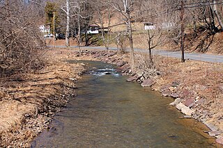
Pine Creek is a tributary of Mahantango Creek in Schuylkill and Dauphin counties, Pennsylvania, in the United States. It is approximately 23.7 miles (38.1 km) long. The creek flows through Foster Township, Hegins Township, Hubley Township, and Upper Mahantango Township in Schuylkill County and Lykens Township in Dauphin County. The creek's watershed has an area of 76.8 square miles (199 km2) and its tributaries include Rausch Creek and Deep Creek. Pine Creek is considered by the Pennsylvania Department of Environmental Protection to be impaired by abandoned mine drainage and resource extraction. However, it is designated as a coldwater fishery.
Fishing Creek is a 29.98-mile (48.25 km) long tributary of the Susquehanna River in Columbia County, Pennsylvania, in the United States. It joins the Susquehanna River near the census-designated place of Rupert and the town of Bloomsburg. The watershed has an area of 385 square miles (1,000 km2).
Mahoning Creek is a tributary of the Susquehanna River in Columbia County and Montour County, in Pennsylvania, in the United States. It is approximately 10.6 miles (17.1 km) long and flows through Madison Township in Columbia County and West Hemlock Township, Derry Township, Valley Township, Mahoning Township, and Danville in Montour County. The watershed of the creek has an area of 39.6 square miles (103 km2). Its tributaries include Kase Run, Mauses Creek, and Sechler Run. Mahoning Creek is designated as a Trout-Stocking Fishery and a Migratory Fishery for part of its length and as a Warmwater Fishery and a Migratory Fishery for the remainder.

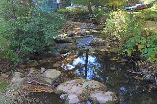
Montour Run is a tributary of Fishing Creek in Columbia County, Pennsylvania. It is the last named tributary to join the creek and is 3.1 miles (5.0 km) long. The stream's watershed has an area of approximately 4.7 square miles and is located in Montour Township, Columbia County and Cooper Township, Montour County. The annual load of sediment in the watershed is 4,248,000 pounds (1,927,000 kg), most of which comes from agricultural lands. Minnows live in the stream.

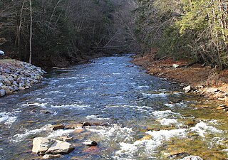
West Creek is a tributary of Fishing Creek, in Columbia County and Sullivan County, in Pennsylvania, in the United States. It is 9.1 miles (14.6 km) long and flows through Davidson Township in Sullivan County and Jackson Township, Sugarloaf Township, Benton Township, and Benton in Columbia County. The water temperature of the creek ranges from 0 °C (32 °F) to 25 °C (77 °F). The discharge ranges from 0 to nearly 10 cubic meters per second. Rock formations in the watershed include the Trimmers Rock Formation, the Catskill Formation, and the Huntley Mountain Formation. The creek's watershed has an area of 16.6 square miles, most of which is agricultural, forested, or urban land. A small number of dams, mills, and schoolhouses were built on West Creek in the 19th and early 20th century. West Creek has the highest level of biodiversity of any stream in the upper Fishing Creek watershed.
West Branch Fishing Creek is one of the northernmost major tributaries of Fishing Creek in Sullivan County, Pennsylvania and Columbia County, Pennsylvania, in the United States. It is 11.1 miles (17.9 km) long and flows through Davidson Township, Sullivan County and Sugarloaf Township, Columbia County. The creek's watershed has an area of 33.5 square miles, nearly all of which is forested land.

Mud Creek is a tributary of Chillisquaque Creek in Columbia County and Montour County in Pennsylvania, in the United States. It is approximately 8.3 miles (13.4 km) long and flows through Madison Township, Columbia County and Derry Township, Montour County. The main tributaries of the creek are unnamed tributaries. The creek's watershed has an area of 17.70 square miles and is in West Hemlock Township, Montour County as well as the two townships it flows through. The watershed is mostly agricultural and forested and the main developed areas are Washingtonville and Jerseytown.

Kase Run is a tributary of Mahoning Creek in Montour County, Pennsylvania, in the United States. It is approximately 4.6 miles (7.4 km) long and flows through West Hemlock Township and Valley Township. The stream's watershed has an area of 7.27 square miles (18.8 km2). The stream and a number of its tributaries are considered by the Pennsylvania Department of Environmental Protection to be impaired by siltation due to agriculture.

Frozen Run is a tributary of Hemlock Creek in Columbia County, Pennsylvania, in the United States. It is approximately 3.2 miles (5.1 km) long and flows through Hemlock Township. The watershed of the stream has an area of 3.55 square miles (9.2 km2). The stream flows through Frosty Valley and is also near a fault. It is designated as a coldwater fishery. Parts of the watershed are impaired due to siltation. The stream has several unnamed tributaries.

Trout Run is a tributary of East Branch Fishing Creek in Sullivan County, Pennsylvania, in the United States. It is approximately 1.5 miles (2.4 km) long and flows through Davidson Township. The watershed of the stream has an area of 0.62 square miles (1.6 km2). The stream is acidic and is considered by the Pennsylvania Department of Environmental Protection to be impaired by atmospheric deposition and metals. Rock formations in the watershed include the Catskill Formation and the Huntley Mountain Formation. Soils in the watershed include the Deep-Wellsboro-Oquaga and Oquaga soil associations.

Big Run is a tributary of East Branch Fishing Creek in Sullivan County, Pennsylvania, in the United States. It is approximately 2.4 miles (3.9 km) long and flows through Davidson Township. Its watershed has an area of 1.38 square miles (3.6 km2). The stream has a low pH and poor water quality, although that could potentially be remedied. The main rock formations in the area are the Catskill Formation, the Huntley Mountain Formation, and the Burgoon Sandstone. The main soil associations in the vicinity of the stream are the Deep-Wellsboro-Oquaga association, the Oquaga association, and the Norwich association.
Scotch Run is one of the main tributaries of Catawissa Creek in Columbia County, Pennsylvania, in the United States. It is approximately 7.8 miles (12.6 km) long and flows through Beaver Township and Main Township. The stream's watershed has an area of 9.10 square miles (23.6 km2). The stream is infertile and acidic. It is 7.2 feet (2.2 m) wide in its upper reaches and 17.0 feet (5.2 m) wide in its lower reaches. The main rock formations in the watershed include the Mauch Chunk Formation, the Pocono Formation, the Pottsville Formation, and the Spechty Kopf Formation. The main soils include Leck Kill soil and Hazleton soil. It flows between Nescopeck Mountain and McCauley Mountain.

Beaver Run is a tributary of Catawissa Creek in Columbia County, Pennsylvania, in the United States. It is approximately 6.2 miles (10.0 km) long and flows through Beaver Township. The stream's watershed has an area of 9.60 miles (15.45 km). Wetlands are present in the watershed. The stream was named by Alexander McCauley in 1774.

Furnace Run is a tributary of Catawissa Creek in Columbia County, Pennsylvania, in the United States. It is approximately 2.5 miles (4.0 km) long and flows through Catawissa Township and Main Township. The stream is the last named tributary to enter Catawissa Creek before its mouth. The stream's watershed has an area of 2.82 square miles (7.3 km2). The main rock formations are the Pottsville Group and the Mauch Chunk Formation. The stream itself is considered to be a high quality coldwater fishery and Class A Wild Trout Waters.

Fisher Run is a tributary of Catawissa Creek in Columbia County, Pennsylvania, in the United States. It is approximately 2.9 miles (4.7 km) long and flows through Main Township and Beaver Township. The stream is impaired by acid mine drainage. It is considered to be a high-quality coldwater fishery and Class A Wild Trout Waters. The watershed of the stream has an area of 3.03 square miles (7.8 km2).

Cranberry Run is a tributary of Catawissa Creek in Columbia County, Pennsylvania, in the United States. It is approximately 2.0 miles (3.2 km) long and flows through Beaver Township. The watershed of the stream has an area of 1.83 square miles (4.7 km2). The stream is considered to be a Coldwater Fishery. The main rock formations in the stream's watershed are the Mauch Chunk Formation and the Pocono Formation and the main soils are the Leck Kill soil and the Hazleton soil.

Logan Run is a tributary of the Susquehanna River in Northumberland County, Pennsylvania, in the United States. It is approximately 5.7 miles (9.2 km) long and flows through Rush Township. The watershed of the stream has an area of 8.70 square miles (22.5 km2) and is in the Lower Susquehanna River drainage basin. The stream is crossed by five bridges and was home to a gristmill and sawmill at some point in the past. It is considered to be a coldwater fishery and a migratory fishery. Rock of the Catskill Formation, the Pocono Formation, and the Hamilton Formation are present in the watershed.

Johnson Creek is a tributary of Lithia Springs Creek in Northumberland County, Pennsylvania, in the United States. It is approximately 2.3 miles (3.7 km) long and flows through Point Township. The watershed of the creek has an area of 4.09 square miles (10.6 km2). It has no named tributaries, but has at least one unnamed tributary. A ridge known as Montour Ridge is in the watershed of the creek and a ravine with high levels of biodiversity is present on one if its tributaries. The creek is considered to be a Coldwater Fishery and a Migratory Fishery.
White Hall Creek is a tributary of East Branch Chillisquaque Creek in Columbia County and Montour County, in Pennsylvania, in the United States. It is approximately 3.8 miles (6.1 km) long and flows through Madison Township in Columbia County and Anthony Township and Derry Township. The watershed of the creek has an area of 2.31 square miles (6.0 km2). All streams in its watershed are impaired by siltation due to agriculture. The creek is a Warmwater Fishery.