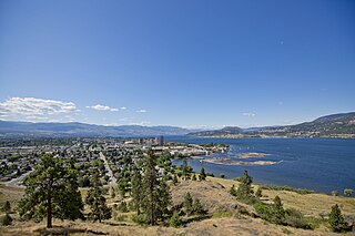
Kelowna is a city on Okanagan Lake in the Okanagan Valley in the southern interior of British Columbia, Canada. It serves as the head office of the Regional District of Central Okanagan. The name Kelowna derives from the Okanagan word kiʔláwnaʔ, referring to a grizzly bear.

Eastgate is a small cabin community located at the Eastern portal of Manning Provincial Park in the Cascade Mountains of British Columbia, Canada. It is located in the Similkameen-Okanagan Forest District. The community store and gas station, and formerly the now closed restaurant, are popular for visitors of Manning Park Resort and ski area. The settlement is located along the uppermost Similkameen River. Access to Eastgate is limited solely to east–west travel along the Hope-Princeton Highway. The community has one gas station, a Canco gas station, a cabin rental and a bed and breakfast. The gas station was formerly host to the Eastgate Canada Post Office. The Eastgate Volunteer Fire Department, with three trucks, provides fire protection for the area and frequently participates in forest fire control in the region. The small town shows up on some government maps as Manning Park.

2014 saw several notable wildfires igniting in California, especially during the month of May, when multiple fires were ablaze concurrently in Southern California, and during September, when several massive wildfires were burning in Northern California. In the context of the 2012–13 North American drought, as well as powerful Santa Ana winds, weather conditions were ideal for wildfires. A total of 7,865 wildfires ignited throughout the year, which burned at least 625,540 acres (2,531.5 km2) of land. The wildfires caused a total of 146 injuries and 2 fatalities, in addition to causing at least $204.05 million in damage.
The Peachland fire was a large wildfire in 2012 in British Columbia.
The Bernardo Fire was a wildfire that occurred during the May 2014 San Diego County wildfire outbreak. The Bernardo fire was the second of the May 2014 wildfires in San Diego County, and the first of the swarm of wildfires that ignited in mid-May, following dry weather and Santa Ana conditions. The fire ignited in 4S Ranch in San Diego County, on May 13, near Del Norte High School, and eventually spread southward and westward, burning 1,548 acres (6 km2) of land. The Bernardo Fire was extinguished on May 17, without causing any significant property losses.

The Manzanita Fire was a wildfire that burned south of the towns of Beaumont and Banning near Highway 79 in Riverside County, California during June 2017. The fire had consumed some 6,309 acres (2,553 ha) and was burning eastward towards the community of Poppet Flats and Highway 243. Fanned by Red Flag conditions, the Manzanita fire ignited from a traffic collision that grew to over 1,200 acres (490 ha) within several hours of burning. The communities of Poppet Flats, Silent Valley and Highland Springs were threatened for a time but no structural damage occurred during this incident. The fire was fully contained on Friday, June 30.
The Wall Fire was a wildfire in 2017 near Bangor in Eastern Butte County, in California, in the United States. Initially named the Wall Incident, due to it starting near Chinese Wall Road, it was reported at 2:52 PM PDT on July 7, 2017. The fire was contained on July 17, 2017, and burned a total of 6,033 acres (2,441 ha).

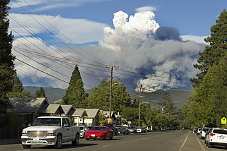
The Creek Fire was a large wildfire that burned in Kagel Canyon and the Angeles National Forest north of Sylmar, a neighborhood in Los Angeles, California, United States, and one of multiple wildfires that broke out across Southern California in December 2017. The Creek Fire burned 15,619 acres (63 km2) and destroyed 123 structures, including 60 homes, before being contained on January 9, 2018, following heavy rainfall from a winter storm. The fire threatened the communities of Santa Clarita, Glendale, Olive View, Lake View Terrace, Sunland-Tujunga, Shadow Hills, Sylmar, Pacoima, Lopez Canyon, and Kagel Canyon, as well as the Olive View–UCLA Medical Center. During the wildfire, 115,000 residents were forced to evacuate their homes.

A series of 29 wildfires ignited across Southern California in December 2017. Six of the fires became significant wildfires, and led to widespread evacuations and property losses. The wildfires burned over 307,900 acres (1,246 km2), and caused traffic disruptions, school closures, hazardous air conditions, and power outages; over 230,000 people were forced to evacuate. The largest of the wildfires was the Thomas Fire, which grew to 281,893 acres (1,140.78 km2), and became the largest wildfire in modern California history, until it was surpassed by the Ranch Fire in the Mendocino Complex, in the following year.

By the end of June, 2018, there had been more than 560 wildfires in British Columbia.
The Mendocino Complex Fire was a large complex of wildfires that burned in northern California for more than three months in 2018. It consisted of two wildfires, the River Fire and Ranch Fire, which burned in Mendocino, Lake, Colusa, and Glenn Counties in the U.S. State of California, with the Ranch Fire being California's single-largest recorded wildfire at the time until the Dixie Fire in 2021. The Ranch Fire burned eight miles northeast of Ukiah, and the River Fire burned six miles north of Hopland, to the south of the larger Ranch Fire. First reported on July 27, 2018, both fires burned a combined total of 459,123 acres (1,858 km2), before they were collectively 100% contained on September 18, though hotspots persisted until the complex was fully brought under control on January 4, 2019. The Ranch Fire alone burned 410,203 acres (1,660 km2), making it the largest wildfire in modern California history at the time until the August Complex fire that occurred in 2020. The Ranch Fire also surpassed the size of the 315,577-acre Rush Fire, which burned across California and Nevada, as well as the Santiago Canyon Fire of 1889, which was previously believed to have been California's all-time largest wildfire.

The 2019 Alberta wildfires have been described by NASA as part of an extreme fire season in the province. In 2019 there were a total of 803,393.32 hectares, which is over 3.5 times more land area burned than in the five-year average burned. The five year average is 747 fires destroying 146,360.08 hectares. There were 644 wildfires recorded in Alberta. By May 31, 10,000 people had been evacuated, 16 homes, and the Steen River CN railway bridge, had been destroyed.
The Red Bank Fire was one of a series of wildfires in Tehama County, California, 25 miles west of Red Bluff. The Red Bank fire was ignited from a series lightning strikes and erupted out of control on Thursday, September 5, 2019. The blaze, along with the South and Henthrone fires, is burning in a remote location, 30 miles south of Redding, California. The fire was contained on September 13 at 8,838 acres (36 km2). Two structures were destroyed.
The Palisades Fire was a wildfire that burned in Topanga State Park, in the Pacific Palisades neighborhood of the city of Los Angeles, California on May 14, 2021. The fire burned a total of 1,202 acres (486 ha) and was fully contained on May 26, 2021.
Binta Lake Fire was a lightning-caused wildfire in Southeast of Burns Lake, British Columbia that started on Wednesday, July 28, 2010, and lasted for more than a month. It was the largest fire in the province in 2010. The fire burned a total area of 400 square kilometers. The fire caused thick smoke in surrounding areas, evacuation orders in the region, and damaged merchantable timber.
The Quail Fire was a wildfire that burned during the 2020 California wildfire season southwest of Winters and north of Vacaville in Solano County, California in the United States. Igniting on Saturday, June 6, within the rural confines of Quail Canyon, the fire ballooned to an estimated 1,837 acres (743 ha) and destroyed three structures including one residential property. The fire was fully contained on Wednesday, June 10, 2020, and the cause remains under investigation.

The North Complex Fire was a massive wildfire complex that burned in the Plumas National Forest in Northern California in the counties of Plumas and Butte. 21 fires were started by lightning on August 17, 2020; by September 5, all the individual fires had been put out with the exception of the Claremont and Bear Fires, which merged on that date, and the Sheep Fire, which was then designated a separate incident. On September 8, strong winds caused the Bear/Claremont Fire to explode in size, rapidly spreading to the southwest. On September 8, 2020, the towns of Berry Creek and Feather Falls were immediately evacuated at 3:15 PM PDT with no prior warning, By September 9, 2020, the towns of Berry Creek and Feather Falls had been leveled, with few homes left standing. The fire threatened the city of Oroville, before its westward spread was stopped. The fire killed 16 people and injured more than 100. Among the 16 fatalities was a 16-year-old boy. The complex burned an estimated 318,935 acres (129,068 ha), and was 100% contained on December 3. The fire was managed by the U.S. Forest Service in conjunction with Cal Fire, with the primary incident base in Quincy. The North Complex Fire was the sixth-largest in California's modern history, and the deadliest fire in the 2020 California wildfire season.
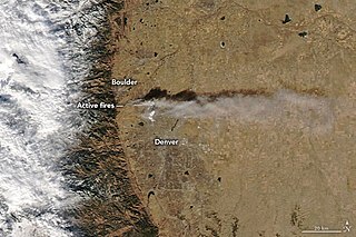
The Marshall Fire was a destructive wildfire and urban conflagration that started on December 30, 2021, shortly after 11:00 a.m. MST, as a grass fire in Boulder County, Colorado. The fire killed two people and became the most destructive fire in Colorado history in terms of buildings destroyed.

The Fawn Fire was a damaging wildfire near Redding, Shasta County, in the U.S. state of California in September and October 2021. Caused by a suspected act of arson in the evening of September 22, the fire began in mountains to the northeast of Redding and was driven by high winds the following day south and west into wildland-urban interface (WUI) neighborhoods. The fire ultimately destroyed 185 structures and damaged 26. Three firefighters engaged in suppression of the fire were injured, but there were no recorded civilian injuries or fatalities. The fire cost more than $25 million to suppress and burned 8,578 acres before being fully contained on October 2. A Palo Alto woman was arrested the day of its ignition and charged with starting the fire. As of 2022, legal proceedings were ongoing.
The McDougall Creek Fire is an ongoing wildfire in the Okanagan region of British Columbia, Canada as part of the 2023 Canadian wildfires. It started near West Kelowna on August 15, 2023 and was discovered at 5:59 pm PDT. The wildfire has forced the evacuation of West Kelowna and parts of Kelowna.