2021 British Columbia wildfires Last updated October 26, 2025 Series of wildfires in 2021
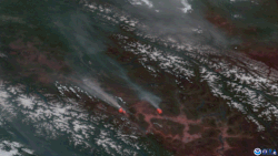
2021 British Columbia wildfires Satellite imagery showing wildfires in British Columbia producing
pyrocumulonimbus clouds spawning lightning strikes.
Date(s) Evacuations: 19th April 2021 Location British Columbia , Canada Land use Forest and residential Deaths 2 Non-fatal injuries Several Structures destroyed Lytton, British Columbia destroyed in Lytton Creek fire, [ 1] Village of Monte Lake destroyed and Paxton Valley destroyedDamage Unknown Cause Lightning and Human-Caused
The 2021 British Columbia wildfires burned across the Canadian province of British Columbia . The severity of the 2021 wildfire season has been attributed to the combination of extreme heat, lower than normal rainfall, and "repeated severe thunderstorms and lightning events" by the BC Wildfire Service, [ 2] all of which were exacerbated by human-caused climate change . [ 3]
As of August 16, over 1,500 fires had been recorded according to the BC Wildfire Service . [ 4] The Sparks Lake Fire was the largest fire burning in the province, having burned an estimated 95,980 hectares (237,172 acres) of the Bonaparte Plateau northwest of the city of Kamloops . [ 5] [ 6] [ 7] [ 8]
Development A heat dome gripped the province of British Columbia , and much of Western North America , from June 25–30, 2021, increasing the risk of wildfires. [ 9]
On June 30, the town of Lytton was evacuated due to a fire that destroyed most buildings and grew to over 300 square miles (780 km 2 ) [ 10] [ 11] and sent people fleeing for their lives.
By July 1, 2021, almost 500 wildfires were burning across British Columbia. On July 20 the B.C. government declared a state of emergency . [ 12]
Wildfires The following is a list of fires that burned more than 405 ha (1,000 acres) , or produced significant structural damage or casualties. More up to date information is available using this interactive map; BC Wildfire Service Map
List of fires over 400 hectares (1,000 acres) Name Regional district Hectares (acres) Start date Containment status Notes Ref George Road Fire Thompson-Nicola 5,017 ha (12,400 acres) June 16 Being held Human-caused [ 13] Beatton River Fire Peace River 3,400 ha (8,400 acres) June 28 Under control Lightning-caused [ 14] Buckinghorse Fire Peace River 6,398 ha (15,810 acres) June 28 Under control Lightning-caused [ 15] Sparks Lake Fire Thompson-Nicola 89,627 ha (221,470 acres) June 28 Under control Largest wildfire by area burned [ 16] McKay Creek Fire Squamish-Lillooet 44,964 ha (111,110 acres) June 29 Under control Suspected human-caused [ 17] Minaker Fire Peace River 2,856 ha (7,060 acres) June 29 Under control Lightning-caused [ 18] Klawli Lake Fire Bulkley-Nechako 6,231 ha (15,400 acres) June 30 Under control Lightning-caused [ 19] Lytton Creek Fire Thompson-Nicola 83,740 ha (206,900 acres) June 30 Under control Destroyed the village of Lytton ; two confirmed casualties [ 20] Mckinley Lake Fire Cariboo 1,835 ha (4,530 acres) June 30 Being held Lightning-caused [ 21] South of Canim Lake Fire Cariboo 3,049 ha (7,530 acres) June 30 Under control Lightning-caused [ 22] SW of Deka Lake Fire Cariboo 650 ha (1,600 acres) June 30 Under control Lightning-caused [ 23] Young Lake Fire Thompson-Nicola 7,453 ha (18,420 acres) June 30 Under control Lightning-caused [ 24] Chilako Fire Bulkley-Nechako 1,451 ha (3,590 acres) July 1 Under control Lightning-caused [ 25] Mount Porter Fire Bulkley-Nechako 13,659 ha (33,750 acres) July 1 Being held Lightning-caused [ 26] Succour Lake Fire Cariboo 1,600 ha (4,000 acres) July 1 Being held Lightning-caused [ 27] Tentfire Creek Fire Peace River 3,148 ha (7,780 acres) July 1 Being held Lightning-caused [ 28] Big Stick Lake Fire Cariboo 7,195 ha (17,780 acres) July 2 Under control [ 29] Black Pine Fire Peace River 16,314 ha (40,310 acres) July 2 Under control Lightning-caused [ 30] Churn Creek Protected Area Fire Thompson-Nicola 12,101 ha (29,900 acres) July 2 Being held Lightning-caused [ 31] Cultus Creek Fire Central Kootenay 2,665 ha (6,590 acres) July 2 Being held Lightning-caused [ 32] Cutoff Creek Fire Bulkley-Nechako 33,418 ha (82,580 acres) July 2 Being held Lightning-caused [ 33] Hotnarko Creek Fire Central Coast 1,500 ha (3,700 acres) July 3 Being held Lightning-caused [ 34] Forres Mountain Fire Peace River 8,700 ha (21,000 acres) July 4 Under control Lightning-caused [ 35] Purdy Lake Fire Cariboo 8,100 ha (20,000 acres) July 5 Under control Lightning-caused [ 36] Bunting Road Fire North Okanagan 5,204 ha (12,860 acres) July 7 Being held [ 37] Chief Louie Lake Fire Bulkley-Nechako 20,750 ha (51,300 acres) July 7 Being held Lightning-caused [ 38] Momich Lake Fire Thompson-Nicola 17,049 ha (42,130 acres) July 7 Under control [ 39] Flat Lake Fire Thompson-Nicola 74,194 ha (183,340 acres) July 8 Under control Lightning-caused [ 40] Akokli Creek Fire Central Kootenay 3,636 ha (8,980 acres) July 9 Being held Lightning-caused [ 41] Embleton Mountain Fire Thompson-Nicola 991 ha (2,450 acres) July 9 Under control [ 42] Hunakwa Lake Fire Columbia-Shuswap 3,601 ha (8,900 acres) July 9 Being held Lightning-caused [ 43] Mowhokam Creek Fire Thompson-Nicola 5,097 ha (12,590 acres) July 9 Being held Lightning-caused [ 44] Trozzo Creek Fire Central Kootenay 5,992 ha (14,810 acres) July 9 Under control Lightning-caused [ 45] Bill Nye Mountain Fire East Kootenay 2,990 ha (7,400 acres) July 10 Being held Lightning-caused [ 46] Crazy Creek Gorge FSR Fire Columbia-Shuswap 4,389 ha (10,850 acres) July 10 Being held Lightning-caused [ 47] Grizzly Lake Fire Bulkley-Nechako 4,891 ha (12,090 acres) July 10 Under control Lightning-caused [ 48] Michaud Creek Fire Central Kootenay 14,032 ha (34,670 acres) July 10 Being held Lightning-caused [ 49] Thomas Creek Fire Okanagan-Similkameen 10,597 ha (26,190 acres) July 11 Being held [ 50] Three Valley Lake Fire Columbia-Shuswap 498 ha (1,230 acres) July 11 Under control [ 51] Tremont Creek Fire Thompson-Nicola 62,524 ha (154,500 acres) July 12 Under control [ 52] Chasm Fire Thompson-Nicola 454 ha (1,120 acres) July 13 Under control Lightning-caused [ 53] July Mountain Fire Thompson-Nicola 19,080 ha (47,100 acres) July 13 Being held Lightning-caused; merged with Brook Creek Fire [ 54] White Rock Lake Fire Thompson-Nicola 81,483 ha (201,350 acres) July 13 Being held Lightning-caused. Destroyed the village of Monte Lake ; part of the city of Kamloops placed under evacuation order, firefighter injured after falling several meters. [ 55] [ 56] Brenda Creek Fire Central Okanagan 824 ha (2,040 acres) July 14 Under control [ 57] Octopus Creek Fire Central Kootenay 22,049 ha (54,480 acres) July 14 Being held Lightning-caused [ 58] Nk'Mip Creek Fire Okanagan-Similkameen 19,335 ha (47,780 acres) July 19 Being held [ 59] Two Mile Road Fire Columbia-Shuswap 2,455 ha (6,070 acres) July 20 Being held [ 60] Garrison Lake Fire Okanagan-Similkameen 14,564 ha (35,990 acres) July 23 Being held [ 61] Pine River Fire Peace River 2,542 ha (6,280 acres) August 13 Being held [ 62] Mt Law Fire Okanagan-Similkameen 976 ha (2,410 acres) August 15 Under control Suspected human-caused. Parts of West Kelowna evacuated. [ 63]
References ↑ Nassar, Hana Mae; Gul, Monika; James, Paul (1 July 2021). " . CKWX . Retrieved 2 July 2021 . ↑ "Wildfire Season Summary - Province of British Columbia" . Government of British Columbia . Retrieved 25 May 2024 . southern regions (especially the Interior) received only 30 per cent of their normal June rainfall. Temperatures climbed steadily throughout June, culminating in a historic heat wave...The dryness and extreme heat raised the fire danger to extreme levels...These conditions persisted through the first half of July, making fuels increasingly susceptible to ignition. The volatility of these fuels, in combination with repeated severe thunderstorms and lightning events, contributed to multiple new wildfires, rapid fire growth, and increased rates of spread on existing wildfires. ↑ Parisien, Marc-André; Barber, Quinn E.; Bourbonnais, Mathieu L.; Daniels, Lori D.; Flannigan, Mike D.; Gray, Robert W.; Hoffman, Kira M.; Jain, Piyush; Stephens, Scott L.; Taylor, Steve W.; Whitman, Ellen (2025-03-08). "Abrupt, climate-induced increase in wildfires in British Columbia since the mid-2000s" . Nature . Vol. 4. doi :10.1038/s43247-023-00977-1 . ↑ "BC Wildfire Dashboard ArcGIS Dashboards" . governmentofbc.maps.arcgis.com . Retrieved 2021-08-17 . ↑ "Wildfires of Note" . bcfireinfo.for.gov.bc.ca . Retrieved 2021-08-17 . ↑ Peters, James (1 July 2021). "TNRD expands evacuation alerts near Sparks Lake wildfire" . CFJC-TV . Archived from the original on 2021-07-01. ↑ "Sparks Lake fire now estimated at 200 square kilometres in size" . Kamloops This Week . 1 July 2021. Archived from the original on 2021-07-02. ↑ "Sparks Lake wildfire remains largest in B.C." Kamloops This Week . July 14, 2021. ↑ Eva Uguen-Csenge, Bethany Lindsay (29 June 2021). "For 3rd straight day, B.C. village smashes record for highest Canadian temperature at 49.6 C" . CBC News . Archived from the original on 2021-06-30. ↑ Lindsay, Bethany; Dickson, Courtney (30 June 2021). "Village of Lytton, B.C., evacuated as mayor says 'the whole town is on fire' . CBC News . Archived from the original on 2021-06-30. ↑ Carrigg, David; Raptis, Mike; Bains, Camille; Brown, Scott (2 July 2021). "B.C. Wildfires: Search underway for Lytton residents missing after village engulfed by fire" . vancouversun . Vancouver Sun . Archived from the original on 2021-07-01. ↑ "B.C. declares state of emergency as wildfires grow, forcing more evacuations" . CBC News . 20 July 2021. Retrieved 21 July 2021 . ↑ "Wildfires of Note George Road K70804" . Government of British Columbia. Archived from the original on 2021-06-18. ↑ "Wildfires of Note Beatton River G81007" . Government of British Columbia. Archived from the original on 2021-07-14. ↑ "Wildfires of Note G80997" . Government of British Columbia. Archived from the original on 2021-07-09. ↑ "Wildfires of Note Sparks Lake K21001" . Government of British Columbia. Archived from the original on 2021-06-30. ↑ "Wildfires of Note Mckay Creek (K71030)" . Government of British Columbia. Archived from the original on 2021-07-02. ↑ "Wildfires of Note G91020" . Government of British Columbia. Archived from the original on 2021-07-14. ↑ "Wildfires of Note Klawli Lake G61132" . Government of British Columbia. Archived from the original on 2021-07-13. ↑ "Wildfires of Note Lytton Creek" . Government of British Columbia. Archived from the original on 2021-07-02. ↑ "Wildfires of Note Mckinley Lake C31056" . Government of British Columbia. Archived from the original on 2021-07-14. ↑ "Wildfires of Note South of Canim Lake C41100" . Government of British Columbia. Archived from the original on 2021-07-14. ↑ "Wildfires of Note SW of Deka Lake C41102" . Government of British Columbia. Archived from the original on 2021-07-02. ↑ "Wildfires of Note Young Lake C41097" . Government of British Columbia. Archived from the original on 2021-07-15. ↑ "Wildfires of Note Chilako G11126" . Government of British Columbia. Archived from the original on 2021-07-06. ↑ "Wildfires of Note Mount Porter G61192" . Government of British Columbia. Archived from the original on 2021-07-13. ↑ "Wildfires of Note Succour Lake C41191" . Government of British Columbia. Archived from the original on 2021-07-14. ↑ "Wildfires of Note Tentfire Creek G71138" . Government of British Columbia. Archived from the original on 2021-07-06. ↑ "Wildfires of Note Big Stick Lake C51290" . Government of British Columbia. Archived from the original on 2021-07-11. ↑ "Wildfires of Note Black Pine G61316" . Government of British Columbia. Archived from the original on 2021-07-13. ↑ "Wildfires of Note Churn Creek Protected Area C21250" . Government of British Columbia. Archived from the original on 2021-07-14. ↑ "Wildfires of Note Cultus Creek Modified Response N71245" . Government of British Columbia. Archived from the original on 2021-07-25. ↑ "Wildfires of Note Cutoff Creek G41269" . Government of British Columbia. Archived from the original on 2021-07-06. ↑ "Wildfires of Note Hotnarko Creek C51355" . Government of British Columbia. Archived from the original on 2021-07-14. ↑ "Wildfires of Note Forres Mountain G61381" . Government of British Columbia. Archived from the original on 2021-07-13. ↑ "Wildfires of Note Purdy Lake C11491" . Government of British Columbia. Archived from the original on 2021-07-14. ↑ "Widlfires of Note Bunting Road K41561" . Government of British Columbia. Archived from the original on 2021-07-20. ↑ "Wildfires of Note Chief Louie Lake R11562" . Government of British Columbia. Archived from the original on 2021-07-18. ↑ "Wildfires of Note Momich Lake K21658" . Government of British Columbia. Archived from the original on 2021-07-18. ↑ "Wildfires of Note Flat Lake C41602" . Government of British Columbia. Archived from the original on 2021-07-14. ↑ "Wildfires of Note Akokli Creek N71686" . Government of British Columbia. Archived from the original on 2021-07-17. ↑ "Wildfires of Note Embleton Mountain K21644" . Government of British Columbia. Archived from the original on 2021-07-12. ↑ "Wildfires of Note Hunakwa Lake K41676" . Government of British Columbia. Archived from the original on 2021-07-17. ↑ "Wildfires of Note Mowhokam Creek V11669" . Government of British Columbia. Archived from the original on 2021-08-08. ↑ "Wildfires of Note Trozzo Creek N51705" . Government of British Columbia. Archived from the original on 2021-07-18. ↑ "Wildfires of Note Bill Nye Mountain-MR N11629" . Government of British Columbia. Archived from the original on 2021-07-17. ↑ "Wildfires of Note Crazy Creek Gorge FSR K41769" . Government of British Columbia. Archived from the original on 2021-08-02. ↑ "Wildfires of Note Grizzly Lake G41711" . Government of British Columbia. Archived from the original on 2021-07-15. ↑ "Wildfires of Note Michaud Creek N51765" . Government of British Columbia. Archived from the original on 2021-07-17. ↑ "Wildfires of Note Thomas Creek K51794" . Government of British Columbia. Archived from the original on 2021-07-13. ↑ "Wildfires of Note Three Valley Lake K41807" . Government of British Columbia. Archived from the original on 2021-07-22. ↑ "Wildfires of Note Tremont Creek K21849" . Government of British Columbia. Archived from the original on 2021-07-14. ↑ "Wildfires of Note Chasm C41866" . Government of British Columbia. Archived from the original on 2021-07-18. ↑ "Widlfires of Note July Mountain K61882" . Government of British Columbia. Archived from the original on 2021-07-20. ↑ "Wildfires of Note White Rock Lake K61884" . Government of British Columbia. Archived from the original on 2021-07-18. ↑ "Firefighter injured after fall on White Rock Lake fire site" . CFGC Today. ↑ "Wildfires of Note Brenda Creek K51924" . Government of British Columbia. Archived from the original on 2021-07-18. ↑ "Wildfires of Note Octopus Creek N51800" . Government of British Columbia. Archived from the original on 2021-07-17. ↑ "Wildfires of Note Nk'Mip Creek K52061" . Government of British Columbia. Archived from the original on 2021-07-20. ↑ "Wildfires of Note Two Mile Road K42078" . Government of British Columbia. Archived from the original on 2021-07-23. ↑ "Wildfires of Note Garrison Lake K62088" . Government of British Columbia. Archived from the original on 2021-07-25. ↑ "Wildfires of Note Pine River G72591" . Government of British Columbia. Archived from the original on 2021-08-18. ↑ "Wildfires of Note Mt Law KK52627" . Government of British Columbia. Archived from the original on 2021-08-16. See also
Africa Asia Europe North America Canada Mexico United States South America Oceania
This page is based on this
Wikipedia article Text is available under the
CC BY-SA 4.0 license; additional terms may apply.
Images, videos and audio are available under their respective licenses.