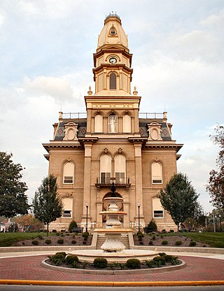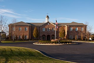
Washington County is a county located in the southeastern part of the U.S. state of Ohio. As of the 2020 census, the population was 59,711. Its county seat is Marietta. The county, the oldest in the state, is named for George Washington. Washington County comprises the Marietta, OH Micropolitan Statistical Area, which is also included in the Parkersburg-Marietta-Vienna, WV-OH Combined Statistical Area.

Vinton County is a county located in the U.S. state of Ohio. As of the 2020 census, the population was 12,800, making it the least populous county of Ohio. Its county seat is McArthur. The county is named for Samuel Finley Vinton, US Representative from Ohio.

Logan County is a county in the west central portion of the U.S. state of Ohio. As of the 2020 census, the population was 46,150. The county seat is Bellefontaine. The county is named for Benjamin Logan, who fought Native Americans in the area. Logan County comprises the Bellefontaine, Ohio Micropolitan Statistical Area, which is also included in the Columbus-Marion-Zanesville, Ohio Combined Statistical Area.

Hocking County is a county located in the U.S. state of Ohio. As of the 2020 census, the population was 28,050. Its county seat is Logan. The county was organized on March 1, 1818, from land given by Athens, Fairfield, and Ross counties. Its name is from the Hocking River, the origins of which are disputed but is said to be a Delaware Indian word meaning "bottle river". Hocking County is included in the Columbus, OH Metropolitan Statistical Area.

Fairfield County is a county located in the U.S. state of Ohio. As of the 2020 census, the population was 158,921. Its county seat and largest city is Lancaster. Its name is a reference to the Fairfield area of the original Lancaster. Fairfield County is part of the Columbus, OH Metropolitan Statistical Area.

Coolville is a village located in Troy Township, Athens County, Ohio, United States, in the southeast area of the state. The population was 452 at the 2020 census.

Nelsonville is a city in northwestern Athens County, Ohio, United States, located about 60 miles (97 km) southeast of Columbus. The population was 5,373 at the 2020 census. It is home to Hocking College as well as Rocky Brands. Nelsonville is surrounded by Ohio's only national forest, the Wayne National Forest.

New Albany is a city in the U.S. state of Ohio, located 15 miles (24 km) northeast of the state capital of Columbus. Most of the city is located in Franklin County and a small portion extends into adjacent Licking County. New Albany had a population of 10,825 at the 2020 census. Founded in 1837, it is a growing suburb in the Columbus metropolitan area.

Laurelville is a village in Hocking County, Ohio, United States. The population was 512 at the 2020 census.

Logan is a city in and county seat of Hocking County, Ohio, United States, along the on the Hocking River about 43 miles (69 km) southeast of Columbus. The population was 7,296 at the time of the 2020 census. The current mayor of Logan is Republican Greg Fraunfelter, who began a four-year term in January 2016 and was re-elected in 2019.

West Liberty is a village in Logan County, Ohio, United States. The population was 1,770 at the 2020 census.

West Mansfield is a village located in Logan County, Ohio, United States. The population was 749 at the 2020 census.

Lorain is a city in Lorain County, Ohio, United States. It is located in Northeast Ohio on Lake Erie at the mouth of the Black River, about 25 miles (40 km) west of Cleveland. As of the 2020 census, the city had a population of 65,211, making it Ohio's ninth-largest city, the third-largest in Greater Cleveland, and the largest in Lorain County by population.

McConnelsville is a village in and the county seat of Morgan County, Ohio, United States, on the east bank of the Muskingum River. Located 21 miles (34 km) southeast of Zanesville and 26 miles (42 km) northwest of Marietta, the population was 1,667 at the 2020 census.

Cuyahoga Falls is a city in Summit County, Ohio, United States. As of the 2020 census, the city population was 51,114. The second-largest city in Summit County, it is located directly north of Akron and is a suburb of the Akron metropolitan area. The city was founded in 1812 by William Wetmore and was originally named Manchester, but renamed for the Cuyahoga River and the series of waterfalls that run along the southern boundary of the city.

Marysville is a city in and the county seat of Union County, Ohio, United States, approximately 27 miles (43 km) northwest of Columbus. The population was 25,571 at the 2020 census. It is part of the Columbus metropolitan area.

Chester is a city in Hancock County, West Virginia, United States. The population was 2,214 at the 2020 census. It is located along the Ohio River in the state's northern panhandle and is the northernmost city in West Virginia. Chester is part of the Weirton–Steubenville metropolitan area and is home to the World's Largest Teapot attraction.

Haydenville is an unincorporated community and census-designated place (CDP) in southern Green Township, Hocking County, Ohio, United States. As of the 2020 census the population of the CDP was 337.

Millersburg is a village and the county seat of Holmes County, Ohio, United States. Located 66 miles (106 km) south of Cleveland, it is in the heart of Ohio's Amish Country and is part of a large regional tourism industry. The population was 3,151 at the 2020 census. Holmes County Airport, located two miles southwest of Millersburg, serves the county.
Kanauga is an unincorporated community and census-designated place (CDP) in Gallia County, Ohio, United States. As of the 2020 census it had a population of 185.


