
The Pacific Ocean is the largest and deepest of Earth's five oceanic divisions. It extends from the Arctic Ocean in the north to the Southern Ocean in the south, and is bounded by the continents of Asia and Oceania in the west and the Americas in the east.

The term 'United States', when used in the geographical sense, refers to the contiguous United States, the state of Alaska, the island state of Hawaii, the five insular territories of Puerto Rico, Northern Mariana Islands, U.S. Virgin Islands, Guam, and American Samoa, and minor outlying possessions. The United States shares land borders with Canada and Mexico and maritime borders with Russia, Cuba, The Bahamas, and other countries, in addition to Canada and Mexico. The northern border of the United States with Canada is the world's longest bi-national land border.
The Western United States is the region comprising the westernmost U.S. states. As American settlement in the U.S. expanded westward, the meaning of the term the West changed. Before around 1800, the crest of the Appalachian Mountains was seen as the western frontier. The frontier moved westward and eventually the lands west of the Mississippi River were considered the West.
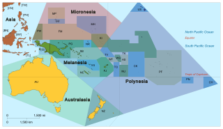
Pacific Islanders, Pasifika, Pasefika, Pacificans or rarely Pacificers are the peoples of the Pacific Islands. As an ethnic/racial term, it is used to describe the original peoples—inhabitants and diasporas—of any of the three major subregions of Oceania.

Temperate rainforest are coniferous or broadleaf forests that occur in the temperate zone and receive heavy rain.

San Pablo Bay is a tidal estuary that forms the northern extension of San Francisco Bay in the East Bay and North Bay regions of the San Francisco Bay Area in northern California.

A subregion is a part of a larger region or continent and is usually based on location. Cardinal directions, such as south are commonly used to define a subregion.

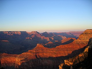
Pacific coast may be used to reference any coastline that borders the Pacific Ocean.
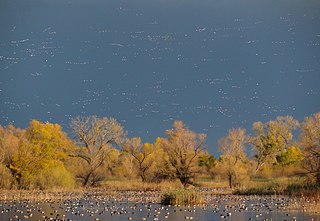
A flyway is a flight path used by large numbers of birds while migrating between their breeding grounds and their overwintering quarters. Flyways generally span continents and often pass over oceans. Although applying to any species of migrating bird, the concept was first conceived and applied to waterfowl and shore birds. The flyways can be thought of as wide arterial highways to which the migratory routes of different species are tributaries. An alternative definition is that a flyway is the entire range of a migratory bird, encompassing both its breeding and non-breeding grounds, and the resting and feeding locations it uses while migrating. There are four major north–south flyways in North America and six covering Eurasia, Africa, and Australasia.

Asia-Pacific (APAC) is the part of the world near the western Pacific Ocean. The Asia-Pacific region varies in area depending on the context, but it often includes countries in East Asia, Southeast Asia, and Oceania that border the Pacific Ocean. South Asia, Mongolia, Myanmar, and the Russian Far East are generally included in a wider Asia-Pacific region.

The approximately 450 Oceanic languages are a branch of the Austronesian languages. The area occupied by speakers of these languages includes Polynesia, as well as much of Melanesia and Micronesia. Though covering a vast area, Oceanic languages are spoken by only two million people. The largest individual Oceanic languages are Eastern Fijian with over 600,000 speakers, and Samoan with an estimated 400,000 speakers. The Gilbertese (Kiribati), Tongan, Tahitian, Māori and Tolai languages each have over 100,000 speakers. The common ancestor which is reconstructed for this group of languages is called Proto-Oceanic.

The Atlantic Flyway is a major north-south flyway for migratory birds in North America. The route generally starts in Greenland, then follows the Atlantic coast of Canada, then south down the Atlantic Coast of the United States to the tropical areas of South America and the Caribbean. Every year, migratory birds travel up and down this route following food sources, heading to breeding grounds, or traveling to overwintering sites.
