
This is a list of properties and historic districts in West Virginia that are listed on the National Register of Historic Places. There are listings in every one of West Virginia's 55 counties.
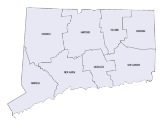
This is a list of properties and districts listed on the National Register of Historic Places in Connecticut. There are more than 1,500 listed sites in Connecticut. All 8 counties in Connecticut have listings on the National Register.

This is a list of properties and districts in Illinois that are on the National Register of Historic Places. There are over 1,800 in total. Of these, 85 are National Historic Landmarks. There are listings in all of the state's 102 counties.
The Lorado Taft Midway Studios are a historic artist studio complex at South Ingleside Avenue and East 60th Street, on the campus of the University of Chicago on the South Side of Chicago. The architecturally haphazard structure, originating as two converted barns and a Victorian house, was used from 1906 to 1929 as the studio of Lorado Taft (1860-1936), one of the most influential sculptors of the period. A National Historic Landmark, it now houses the university's visual arts department.

The Bremond Block Historic District is a collection of eleven historic homes in downtown Austin, Texas, United States, constructed from the 1850s to 1910.

This list is of the properties and historic districts that are designated on the National Register of Historic Places or that were formerly so designated, in Hennepin County, Minnesota; there are 169 entries as of November 2018. A significant number of these properties are a result of the establishment of Fort Snelling, the development of water power at Saint Anthony Falls, and the thriving city of Minneapolis that developed around the falls. Many historic sites outside the Minneapolis city limits are associated with pioneers who established missions, farms, and schools in areas that are now suburbs in that metropolitan area.

This is a list of the National Register of Historic Places listings in Cabell County, West Virginia.
Franklin Square Historic District is a national historic district in Baltimore, Maryland, United States. It is a 19th-century rowhouse neighborhood developed along a strict grid street pattern. A one square block, two and a half acre public park, Franklin Square, is a focal point for the area and the most elaborate rowhousing surrounds the square. The district contains approximately 1,300 buildings of which approximately 1,250 contribute to the significance of the historic district.

This is a list of National Register of Historic Places listings in New Haven, Connecticut.

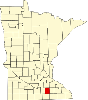
This is a list of the National Register of Historic Places listings in Kandiyohi County, Minnesota. It is intended to be a complete list of the properties and districts on the National Register of Historic Places in Kandiyohi County, Minnesota, United States. The locations of National Register properties and districts for which the latitude and longitude coordinates are included below, may be seen in an online map.
The Ravenswood Manor Historic District is a historic district in the Albany Park community area of North Side, Chicago, Illinois. It is bordered by the Chicago River on the East, and by the alley south of Lawrence Avenue on the North, Sacramento Avenue on the West, and the alley North of Montrose Avenue on the south.
This is a list of the National Register of Historic Places listings in Steele County, Minnesota. It is intended to be a complete list of the properties and districts on the National Register of Historic Places in Steele County, Minnesota, United States. The locations of National Register properties and districts for which the latitude and longitude coordinates are included below, may be seen in an online map.
There are 67 sites in the National Register of Historic Places listings in West Side, Chicago, out of more than 350 listings in the City of Chicago. The West Side is defined for this article as the area north of the Chicago Sanitary and Ship Canal, south of Fullerton Avenue, west of the Chicago River and east of the western city limits. One site, Logan Square Boulevards Historic District, spans a border and is included also in listings on the North Side. The Chicago Sanitary and Ship Canal Historic District extends through Cook County west of Chicago, DuPage County and Will County to Lockport.
There are 94 sites on the National Register of Historic Places listings in South Side Chicago — of more than 350 total listings within the City of Chicago, in Cook County, Illinois.
There are 94 sites in the National Register of Historic Places listings in North Side Chicago — of 374 listings within the City of Chicago, in Cook County, Illinois.

The Museum District, alternately known as West of the Boulevard, or the Upper Fan, is a neighborhood in the city of Richmond, Virginia. It is anchored by the contiguous six-block tract of museums along the west side of Boulevard, including the Virginia Museum of Fine Arts and the Virginia Museum of History & Culture, hence the name.
Woodward Heights is a neighborhood and historic district located immediately west of downtown Lexington, Kentucky. It is bounded by Maxwell Street and the Pleasant Green Hill neighborhood to the southwest, by the parking lot for Rupp Arena to the southeast, by the Lexington Convention Center property to the northeast, and by Herlihy, Cox, and High Streets to the north.
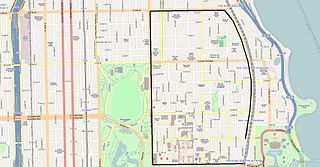
Hyde Park–Kenwood Historic District is the name of the National Register of Historic Places (NRHP) district on the South Side of Chicago that includes parts of the Hyde Park and Kenwood community areas of Chicago, Illinois. The northern part of this district overlaps with the officially designated Chicago Landmark Kenwood District. This northern part of the Hyde Park–Kenwood Historic District contains the Chicago home of Barack Obama. The entire district was added to the NRHP on February 14, 1979 and expanded on August 16, 1984 and May 16, 1986. The district is bounded to the north, south, east and west, respectively by 47th Street, 59th Street, Lake Park Avenue and Cottage Groves Avenue. Despite the large amount of property associated with the University of Chicago, the Hyde Park–Kenwood Historic District is mostly residential. The district is considered to be significant for its architecture and education.

The Pilsen Historic District is a historic district located in the Pilsen neighborhood of Chicago. Pilsen is a neighborhood made up of the residential sections of the Lower West Side community area of Chicago. In the late 19th century Pilsen was inhabited by Czech immigrants who named the district after Plzeň, the fourth largest city in what is now the Czech Republic. The population also included in smaller numbers other ethnic groups from the Austro-Hungarian Empire including Slovaks, Slovenes, Croats and Austrians, as well as immigrants of Polish and Lithuanian heritage.

Upper Main Street Historic District is a nationally recognized historic district located in Dubuque, Iowa, United States. It was listed on the National Register of Historic Places in 2005. At the time of its nomination it consisted of 24 resources, which included 18 contributing buildings, and six non-contributing buildings. In 2011 the boundaries of the district were expanded to include four additional buildings on the west side of the 900 block of Main Street. The district is the northern end of the city's most important commercial street. It is situated on a level terrace above the downtown area, located to the east. The buildings located on the east side of Main Street have exposed foundations along the alley because the grade descends in that direction. For the most part the district is made up of commercial buildings, although there is one house, four rowhouses, and a church. All of the buildings are masonry construction, and they are between one and four stories tall. The bell tower of St. Luke's United Methodist Church (1896) is equivalent to an eight-story building. St. Luke's Church and the Interstate Power Company Building are individually listed on the National Register.


