In physical geography, a fjord or fiord is a long, narrow inlet with steep sides or cliffs, created by a glacier. Fjords exist on the coasts of Antarctica, British Columbia (Canada), Chile, Denmark, Germany, Greenland, the Faroe Islands (Denmark), Montenegro, Iceland, Ireland, Kamchatka (Russia), the Kerguelen Islands (France), Newfoundland and Labrador (Canada), New Zealand, Norway, Novaya Zemlya (Russia), Nunavut (Canada), Quebec (Canada), Argentina, Russia, South Georgia Island (U.K.), Tasmania (Australia), Scotland and the states of Washington and Alaska. Norway's coastline is estimated to be 29,000 km (18,000 mi) long with its nearly 1,200 fjords, but only 2,500 km (1,600 mi) long excluding the fjords.

The Continental Divide of the Americas is the principal, and largely mountainous, hydrological divide of the Americas. The Continental Divide extends from the Bering Strait to the Strait of Magellan, and separates the watersheds that drain into the Pacific Ocean from those river systems that drain into the Atlantic and Arctic oceans.
Gros Morne National Park is a Canadian national park and World Heritage Site located on the west coast of Newfoundland. At 1,805 km2 (697 sq mi), it is the second largest national park in Atlantic Canada after Torngat Mountains National Park, which has an area of 9,700 km2 (3,700 sq mi).

A megatsunami is a very large wave created by a large, sudden displacement of material into a body of water.

Jökulsárlón is a large glacial lake in southern part of Vatnajökull National Park, Iceland. Situated at the head of the Breiðamerkurjökull glacier, it developed into a lake after the glacier started receding from the edge of the Atlantic Ocean. The lake has grown since then at varying rates because of melting of the glaciers. It is now about 8 km (5.0 mi) away from the ocean's edge and covers an area of about 18 km2 (6.9 sq mi). In 2009 it was reported to be the deepest lake in Iceland, at over 284 m (932 ft), as glacial retreat extended its boundaries. The size of the lake has increased fourfold since the 1970s.

A body of water or waterbody is any significant accumulation of water on the surface of Earth or another planet. The term most often refers to oceans, seas, and lakes, but it includes smaller pools of water such as ponds, wetlands, or more rarely, puddles. A body of water does not have to be still or contained; rivers, streams, canals, and other geographical features where water moves from one place to another are also considered bodies of water.
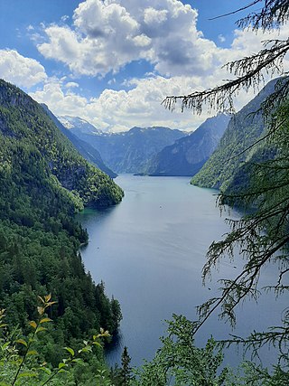
The Königssee is a natural lake in the southeast Berchtesgadener Land district of the German state of Bavaria, near the Austrian border. Most of the lake is within the Berchtesgaden National Park.
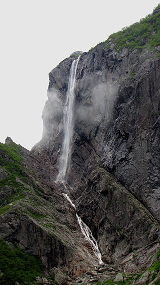
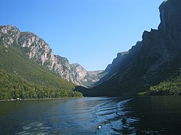
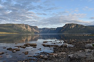
Pissing Mare Falls is a tiered waterfall in Gros Morne National Park, Newfoundland, Canada. It is formed from Burnt Woods Brook, which plunges over the edge of Big Level Plateau into Western Brook Pond. At 343 m (1,125 ft) high, with an unbroken drop of 250 m (820 ft), it is the highest in the province and the 31st highest in Canada.

The Great Northern Peninsula is the largest and longest peninsula of Newfoundland, Canada, approximately 270 km long and 90 km wide at its widest point and encompassing an area of 17,483 km2. It is defined as that part of Newfoundland from Bonne Bay northwards around Cape Norman and Cape Bauld and thence southwards to the head of White Bay, bounded by the Gulf of St. Lawrence on the west, the Strait of Belle Isle on the north and the Labrador Sea and White Bay on the east.

Hardangervidda National Park, at 3,422 square kilometres (1,321 sq mi), is Norway's largest national park. It spans from Numedal and Uvdal in the east and Røvelseggi and Ullensvang in the west across the Hardanger mountain plateau (Hardangervidda). Designated as a national park in 1981, today it serves as a popular tourist destination for activities such as hiking, climbing, fishing, and cross-country skiing. The Norwegian Mountain Touring Association (DNT) maintains a comprehensive network of huts and paths across Hardangervidda. The Bergen Line and the main Highway 7 cross the plateau. The park lies in Viken, Vestland, and Vestfold og Telemark counties.

Many Glacier is an area within Glacier National Park which is located in the U.S. state of Montana. The Many Glacier region is located north of the Going-to-the-Sun Road, on the east side of the park. Lake Sherburne is the large lake in the area and the Many Glacier Hotel, the largest hotel within the park, is along the shore of the adjacent Swiftcurrent Lake. The Many Glacier Hotel and surrounding buildings are a National Historic Landmark, with original construction dating back to 1915. Many Glacier is surrounded by the high peaks of the Lewis Range, and numerous hiking trails can be accessed from the area. The region is noted for numerous lakes, waterfalls and dense coniferous forests interspersed with alpine meadows. Major sites in the immediate vicinity that can be accessed by trails include Lake Josephine, Grinnell Lake, Grinnell Glacier, Cracker Lake, Granite Park Chalet, Iceberg Cirque and the Ptarmigan Tunnel, which is a hiking tunnel carved through the mountainside during the 1930s. Tour boats allow visitors an opportunity to venture onto Swiftcurrent Lake. Other activities in the region include ranger guided nature hikes, horseback riding, fishing and camping.

U-shaped valleys, also called trough valleys or glacial troughs, are formed by the process of glaciation. They are characteristic of mountain glaciation in particular. They have a characteristic U shape in cross-section, with steep, straight sides and a flat or rounded bottom. Glaciated valleys are formed when a glacier travels across and down a slope, carving the valley by the action of scouring. When the ice recedes or thaws, the valley remains, often littered with small boulders that were transported within the ice, called glacial till or glacial erratic.

Bonne Bay is a bay in Newfoundland, Canada. It is located on the western coast of Newfoundland and separates the Great Northern Peninsula from the rest of the island. It is a part of Gros Morne National Park.

Newfoundland and Labrador is the easternmost province in Canada. The Strait of Belle Isle separates the province into two geographical regions, Labrador and the island of Newfoundland. The province also includes over seven thousand small islands.

Bonne Bay Marine Station is a marine ecology research and teaching facility on Bonne Bay along Newfoundland's west coast. It offers services to students, researchers, educators and the general public. The station is within Gros Morne National Park, a recognized UNESCO World Heritage Site. The aquarium portion of the facility is open to visitors. Interactive aquariums tours are provided to walk-ins, as well as school and community groups. The tour offers exhibits the latest research while showcasing marine flora and fauna in the station's aquaria and touch tank. Officially opened on 6 Sept, 2002, the Bonne Bay Marine Station is operated by Memorial University of Newfoundland and the Gros Morne Co-operating Association. Funding was provided by Atlantic Canada Opportunities Agency (ACOA) and the Newfoundland and Labrador Provincial Government.
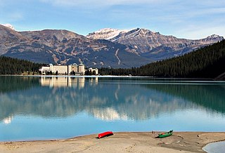
Lake Louise is a glacial lake within Banff National Park in Alberta, Canada. Situated 11 km (6.8 mi) east of the border with British Columbia, Lake Louise is located 5 km (3.1 mi) west of the hamlet of Lake Louise and the Trans-Canada Highway.
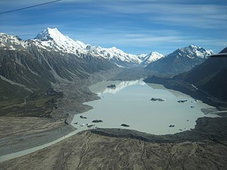
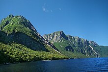
Tasman Lake is a proglacial lake formed by the recent retreat of the Tasman Glacier in New Zealand's South Island.

Route 430 is a 413-kilometre-long (257 mi) paved highway that traverses the Great Northern Peninsula of Newfoundland in the Canadian province of Newfoundland and Labrador. The route begins at the intersection of Route 1 in Deer Lake and ends in St. Anthony. Officially known as the Great Northern Peninsula Highway, it has been designated as the Viking Trail since it is the main auto route to L'Anse aux Meadows, the only proven Viking era settlement in North America. It is the primary travel route in the Great Northern Peninsula and the only improved highway between Deer Lake and St. Anthony. It is the main access route to the Labrador Ferry terminal in St. Barbe.

The 1958 Lituya Bay earthquake occurred on PST with a moment magnitude of 7.8 to 8.3 and a maximum Mercalli intensity of XI (Extreme). The strike-slip earthquake took place on the Fairweather Fault and triggered a rockslide of 30 million cubic meters and about 90 million tons into the narrow inlet of Lituya Bay, Alaska. The impact was heard 80 kilometers (50 mi) away, and the sudden displacement of water resulted in a megatsunami that washed out trees to a maximum elevation of 524 meters at the entrance of Gilbert Inlet. This is the largest and most significant megatsunami in modern times; it forced a re-evaluation of large-wave events and the recognition of impact events, rockfalls, and landslides as causes of very large waves.