
Lincoln is a cathedral city and county town of Lincolnshire in the East Midlands of England. The non-metropolitan district of Lincoln had a 2012 population of 94,600. The 2011 census gave the urban area of Lincoln, which includes North Hykeham and Waddington, a population of 115,000. Roman Lindum Colonia developed from an Iron Age settlement on the River Witham. Landmarks include Lincoln Cathedral – an example of English Gothic architecture, which for over 200 years was the world's tallest building – and the 11th-century Norman Lincoln Castle. The city hosts the University of Lincoln and Bishop Grosseteste University, and Lincoln City FC and Lincoln United FC.

Lincolnshire is a county in the East Midlands of England, with a long coastline on the North Sea to the east. It borders Norfolk to the south-east, Cambridgeshire to the south, Rutland to the south-west, Leicestershire and Nottinghamshire to the west, South Yorkshire to the north-west, and the East Riding of Yorkshire to the north. It also borders Northamptonshire in the south for just 20 yards (19 m), England's shortest county boundary. The county town is the city of Lincoln, where the county council has its headquarters.
Sleaford is a market town and civil parish in the district of North Kesteven, in Lincolnshire, England. Since 1973, the parish has included Quarrington to the south-west, Holdingham to the north and Old Sleaford to the east – contiguous settlements and former civil parishes that had formed with New Sleaford an Urban District. The town is on the edge of the fertile Fenlands, about 11 miles north-east of Grantham, 16 mi (26 km) west of Boston, and 17 mi (27 km) south of Lincoln. Its population of 17,671 at the 2011 Census made it the largest settlement in the North Kesteven district. Bypassed by the A17 and the A15, it is linked to Lincoln, Newark, Peterborough and King's Lynn. Sleaford railway station is on the Nottingham to Skegness and Peterborough to Lincoln Lines.

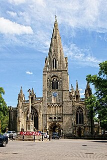
Skegness is a seaside town and civil parish in the East Lindsey District of Lincolnshire, England. On the Lincolnshire coast of the North Sea, the town is 43 miles (69 km) east of Lincoln and 22 miles (35 km) north-east of Boston. With a population of 19,579 as of 2011, it is the largest settlement in East Lindsey. It also incorporates Winthorpe and Seacroft, and forms a larger built-up area with the resorts of Ingoldmells and Chapel St Leonards to the north. The town is on the A52 and A158 roads, connecting it with Boston and the East Midlands, and Lincoln respectively. Skegness railway station is on the Nottingham to Skegness line.

Horncastle is a town and civil parish in Lincolnshire, 17 miles (27 km) east of Lincoln. Its population was 6,815 at the 2011 census, and was estimated to be 7,123 in 2019. A section of the ancient Roman walls remains.

Caistor is a town and civil parish in the West Lindsey district of Lincolnshire, England. As its name implies, it was originally a Roman castrum or fortress. It lies at the north-west edge of the Lincolnshire Wolds, on the Viking Way, and just off the A46 between Lincoln and Grimsby, at the A46, A1084, A1173 and B1225 junction. It has a population of 2,601. Its name comes from the Anglo-Saxon ceaster and was given in the Domesday Book as Castre.

Lincoln Castle is a major Norman castle constructed in Lincoln, England, during the late 11th century by William the Conqueror on the site of a pre-existing Roman fortress. The castle is unusual in that it has two mottes. It is one of only two such castles in the country, the other being at Lewes in East Sussex. Lincoln Castle remained in use as a prison and court into modern times and is one of the better preserved castles in England; the Crown Courts continue to this day. It is open to the public most days of the week and possible to walk around the walls from which there are views of the castle complex, cathedral, the city, and surrounding countryside. The castle is now owned by Lincolnshire County Council and is a scheduled monument.

Bracebridge Heath is a commuter village located approximately 2 miles (3 km) south from the city and county town of Lincoln, England. It lies at the junction of two major roads the A15 to Sleaford and the A607 to Grantham, and was part of the Boothby Graffoe Wapentake. The village sits on top of Lincoln Cliff, overlooking Lincoln and the valley of the River Witham. The Viking Way runs along the cliff top, a 147 miles (237 km) long footpath, which runs from the Humber Bridge to Oakham. Its population at the 2001 census was 4,530, increasing to 5,656 at the 2011 census.
King Edward VI Grammar School is a grammar school located in Louth, Lincolnshire, England.
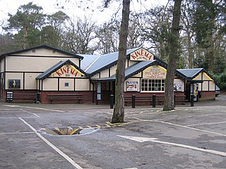
Woodhall Spa is a former spa town and civil parish in Lincolnshire, England, on the southern edge of the Lincolnshire Wolds, 6 miles (10 km) south-west of Horncastle, 23 miles (37 km) west of Skegness, 15 miles (24 km) east-south-east of Lincoln and 17 miles (27 km) north-west of Boston. It is noted for its mineral springs, cinema and its Second World War association with the RAF 617 Squadron. The cinema has the last remaining rear screen projector in the country.

Wainfleet All Saints is an ancient port and market town on the east coast of England, in the East Lindsey district of Lincolnshire, on the A52 road 5 miles (8 km) south-west of Skegness and 14 miles (23 km) north-east of Boston. It stands on two small rivers, the Steeping and Limb, that form Wainfleet Haven. The town is close to the Lincolnshire Wolds. The village of Wainfleet St Mary is to the south.

Caythorpe is a large village and civil parish in the South Kesteven district of Lincolnshire, England. The population at 2011 census was 1,374. It is situated on the A607, approximately 3 miles (5 km) south from Leadenham and 9 miles (14 km) north from Grantham. Caythorpe Heath stretches east of the village to Ermine Street and Byards Leap.

Swinderby railway station serves the villages of Swinderby, North Scarle, Eagle and Morton Hall in Lincolnshire, England. The station is 8.75 miles (14 km) south west of Lincoln Central on the Nottingham to Lincoln Central Line, owned by Network Rail and managed by East Midlands Railway who provide all services.
Cowbit is a village and civil parish in the South Holland district of Lincolnshire, England. The population of the civil parish at the 2011 census was 1,220. It is situated 3 miles (5 km) south from Spalding and 5 miles (8 km) north from Crowland.
Navenby is a village and civil parish in Lincolnshire, England. Lying 8 miles (13 km) south from the county town of Lincoln and 9 miles (14 km) north-northwest from Sleaford, Navenby had a population of 2,128 at the time of the 2011 census and is a dormitory village for Lincoln. It forms part of the North Kesteven local government district and, in March 2011, it was named as the 'Best Value Village' in England following a national survey.
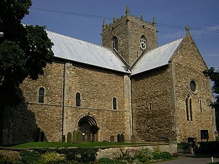
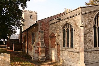
The Minster Church of St Mary, Stow in Lindsey, is a major Anglo-Saxon church in Lincolnshire and is one of the largest and oldest parish church buildings in England. It has been claimed that the Minster originally served as the cathedral church of the diocese of Lindsey, founded in the 7th century and is sometimes referred to as the "Mother Church of Lincolnshire".

St James' Church, Louth is a parish church of the Church of England in Louth, Lincolnshire, England. It is notable for its tall spire.
The River Till is a river in the county of Lincolnshire in England and is ultimately a tributary of the River Witham. Its upper reaches drain the land east of Gainsborough. The middle section is embanked, as the water level is higher than that of the surrounding land, and pumping stations pump water from low level drainage ditches into the river. Its lower reaches from the hamlet of Odder near Saxilby into the city of Lincoln were canalised, possibly as early as Roman times, as part of the Foss Dyke.

Lincoln Corporation Waterworks and its predecessors and successors have provided a public water supply and sewerage and sewage treatment services to the city of Lincoln, England.

Bellmount Tower is a historic tower, dating to the 18th-century, located near Belton Park, Belton, Lincolnshire, England. It is a grade II* listed building. It was commissioned by John Brownlow, 1st Viscount Tyrconnel as one of several buildings on the Belton estate. It was remodelled in c.1780, damaged by fire in 1841, and restored in 1989.

