| Weston Hall | |||||||||||||||||||||||||||||||||
|---|---|---|---|---|---|---|---|---|---|---|---|---|---|---|---|---|---|---|---|---|---|---|---|---|---|---|---|---|---|---|---|---|---|
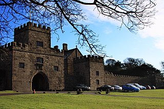
 Weston Hall East front | |||||||||||||||||||||||||||||||||
| |||||||||||||||||||||||||||||||||
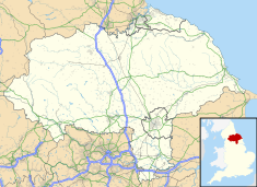 Location of Weston Hall in North Yorkshire | |||||||||||||||||||||||||||||||||
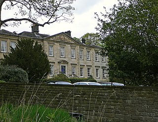
Weston Hall is a country house and Grade I listed building in Weston, North Yorkshire, England. [1]
| Weston Hall | |||||||||||||||||||||||||||||||||
|---|---|---|---|---|---|---|---|---|---|---|---|---|---|---|---|---|---|---|---|---|---|---|---|---|---|---|---|---|---|---|---|---|---|
| Weston Hall East front | |||||||||||||||||||||||||||||||||
| |||||||||||||||||||||||||||||||||
| Location of Weston Hall in North Yorkshire | |||||||||||||||||||||||||||||||||
Weston Hall is a country house and Grade I listed building in Weston, North Yorkshire, England. [1]
The house has been in the Vavasour, (Dawson after 1833) family, since the 14th century. [2] It may contain a medieval core, with a "Weston Hall" being mentioned in 1378. [3] However, it was largely rebuilt during the reign of Elizabeth I, of which period it retains most external features. [3]
There is also a notable Tudor or Jacobean banqueting house, called the Banqueting Hall, built for Sir Mager Vavasour, which is Grade I listed. [4] It is 3 storeys high and has a stair turret with a gazebo at the top. [3] There is a 16th century or earlier tithe barn to the South of the house, [3] which is Grade II* listed. [5]
The Hall and Banqueting Hall were formerly Grade II* listed, [3] but were upgraded. [1] [4]

Turweston is a village and civil parish in north-west Buckinghamshire, England. The village is beside the River Great Ouse, which bounds the parish to the north, west and south. Turweston is the most northwesterly parish in Buckinghamshire: the Ouse here forms the county boundary with Northamptonshire to the north and west and Oxfordshire to the south. Across the river, the Northamptonshire market town of Brackley is just west of Turweston, with the town centre about 1 mile (1.6 km) west of the village. The parish has an area of 1,295 acres (524 ha) and had a population of 211 at the 2011 Census.

Pembridge is a village and civil parish in Arrow valley in Herefordshire, England. The village is on the A44 road about 6 miles (10 km) east of Kington and 7 miles (11 km) west of Leominster. The civil parish includes the hamlets of Bearwood, Lower Bearwood, Lower Broxwood, Marston, Moorcot and Weston. The 2011 Census recorded the parish population as 1,056.

Weston Park is a country house in Weston-under-Lizard, Staffordshire, England, set in more than 1,000 acres (400 ha) of park landscaped by Capability Brown. The park is located 10 miles (16 km) north-west of Wolverhampton, and 8 miles (13 km) east of Telford, close to the border with Shropshire. The 17th-century Hall is a Grade I listed building and several other features of the estate, such as the Orangery and the Stable block, are separately listed as Grade II.

Stoke St Gregory is a village and civil parish in Somerset, England, about 7 miles (11 km) east of Taunton. The village is on a low ridge of land between the River Tone to the north and West Sedgemoor to the south. The 2011 Census recorded the parish's population as 942.
Hoghton Tower is a fortified manor house two-thirds of a mile (1 km) east of the village of Hoghton, Lancashire, England, and standing on a hilltop site on the highest point in the area. It takes its name from the de Hoghton family, its historical owners since at least the 12th century. The present house dates from about 1560–65.
Compton Bishop is a small village and civil parish, at the western end of the Mendip Hills in the English county of Somerset. It is located close to the historic town of Axbridge. Along with the village of Cross and the hamlets of Rackley and Webbington it forms the parish of Compton Bishop and Cross.
Arley Hall is a country house in the village of Arley, Cheshire, England, about 4 miles (6 km) south of Lymm and 5 miles (8 km) north of Northwich. It is home to the owner, Viscount Ashbrook, and his family. The house is a Grade II* listed building, as is its adjacent chapel. Formal gardens to the southwest of the hall are also listed as Grade II* on the National Register of Historic Parks and Gardens. In the grounds are more listed buildings, a cruck barn being listed as Grade I, and the other buildings as Grade II.
Weston is a village and civil parish in the Harrogate district of North Yorkshire, England. The village is 1.2 miles (2 km) north–west of Otley and near the River Wharfe which forms the boundary between North and West Yorkshire. The name is from Old English and means western enclosure, farmstead or village.

Runcorn is an industrial town in Halton, Cheshire, England, on the south bank of the River Mersey where it narrows at Runcorn Gap. In the town are the 61 buildings that are recorded in the National Heritage List for England as designated listed buildings in the current urban area of Runcorn, including the districts of Runcorn, Halton, Weston, Weston Point, and Norton. Two of these are classified as being in Grade I, nine in Grade II*, and 51 in Grade II.

Stoke sub Hamdon Priory is a complex of buildings and ruins which initially formed a 14th-century college for the chantry chapel of St Nicholas, and later was the site of a farm in Stoke-sub-Hamdon, Somerset, England. The only building remaining from the college is a great hall and attached dwelling, dating from the late 15th century. The hall is designated by English Heritage as a Grade I listed building, while the outbuildings and gateway are Grade II listed. The whole site has been scheduled as an ancient monument. A number of the farm buildings are in poor condition, and have been added to the Heritage at Risk Register.

Sutton Hall is a historic farmhouse, south of the village of Sutton Weaver in Cheshire, England. It is recorded in the National Heritage List for England as a designated Grade I listed building.


Swarkestone Hall Pavilion, also known as Swarkestone Stand and The Grandstand, is a 17th-century pavilion 200 metres north of the ruins of Swarkestone Hall, Swarkestone, Derbyshire. It is a Grade I listed building south of Chellaston on the A514.

Westwell is a small village and civil parish about 2 miles (3 km) southwest of the market town of Burford in Oxfordshire. It is the westernmost village in the county, close to the border with Gloucestershire.

Rivington in the Borough of Chorley, Lancashire, is situated on the edge of the West Pennine Moors, at the foot of Rivington Pike overlooking reservoirs created for Liverpool Corporation Waterworks in the 19th century. There are twenty eight listed buildings within Rivington, two are classified by English Heritage as Grade II*, the rest as Grade II; Rivington has no Grade I Listed buildings.
The S35 district lies within the City of Sheffield, South Yorkshire, England. The district contains 70 listed buildings that are recorded in the National Heritage List for England. Of these, one is listed at Grade I, the highest of the three grades, four are at Grade II*, the middle grade, and the others are at Grade II, the lowest grade. The district is in the north east of the city of Sheffield, and covers the areas of Brightholmlee, Burncross, Chapeltown, Ecclesfield, Grenoside, High Green, Onesacre, Oughtibridge, Wharncliffe Side, Whitley and Worrall, plus part of Middlewood.
Heskin is a civil parish in the Borough of Chorley, Lancashire, England. It contains 17 buildings that are recorded in the National Heritage List for England as designated listed buildings. Of these, one is listed at Grade I, the highest of the three grades, one is at Grade II*, the middle grade, and the others are at Grade II, the lowest grade. The parish is almost completely rural, and most of the listed buildings are, or originated as, farmhouses and farm buildings. The other listed buildings are large houses and associated structures, and a cottage.
Scarisbrick is a civil parish in the West Lancashire district and borough of Lancashire, England. It contains 32 buildings and structures that are recorded in the National Heritage List for England as designated listed buildings. Of these, one is listed at Grade I, the highest of the three grades, and the others are at Grade II, the lowest grade. The most significant building in the parish is Scarisbrick Hall which is listed at Grade I, with several associated structures being listed separately. The parish is a collective of smaller hamlets and is largely rural. Many of the listed buildings are houses, farmhouses or other agricultural buildings that have since been repurposed as dwellings, while the others include a telephone kiosk and the Roman Catholic Church of St Elizabeth.

Bradfield Dale is a rural valley 12 kilometres (7.5 mi) west-northwest of the City of Sheffield in England. The valley stands within the north-eastern boundary of the Peak District National Park just west of the village of Low Bradfield. The dale is drained by the Strines Dike which becomes the Dale Dike lower down the valley, these being the headwaters of the River Loxley. The dale contains two reservoirs, Strines and Dale Dike, and a third, Agden Reservoir, stands in a side valley just above Low Bradfield. The dale is characterised by agricultural land interspersed with farming and residential buildings. It is approximately 5 kilometres (3.1 mi) long from its foot at Low Bradfield to its head on Strines Moor.
Field House is a Grade II* listed privately owned historic house in Sowerby Bridge, West Yorkshire, England.