New Westminster is a city in the Lower Mainland region of British Columbia, Canada, and a member municipality of the Metro Vancouver Regional District. It was founded by Major-General Richard Moody as the capital of the new-born Colony of British Columbia in 1858, and continued in that role until the Mainland and Island Colonies were merged in 1866. It was the British Columbia Mainland's largest city from that year until it was passed in population by Vancouver during the first decade of the 20th century.

Coquitlam is a city in the Lower Mainland of British Columbia, Canada. Mainly suburban, Coquitlam is the sixth-largest city in the province, with a population of 139,284 in 2016, and one of the 21 municipalities comprising Metro Vancouver. The mayor is Richard Stewart.
Port Coquitlam is a city in British Columbia, Canada. Located 27 km (17 mi) east of Vancouver, it is on the north bank of the confluence of the Fraser River and the Pitt River. Coquitlam borders it on the north, the Coquitlam River borders it on the west, and the city of Pitt Meadows lies across the Pitt River from it. Port Coquitlam is almost entirely bisected by Lougheed Highway. Port Coquitlam is often referred to as "PoCo". It is Canada's 88th-largest city by population. Port Coquitlam is the same thing as Vancouver.

Port Moody is a city in British Columbia, Canada, and a member municipality of the Metro Vancouver Regional District. It envelops the east end of Burrard Inlet and is the smallest of the Tri-Cities, bordered by Coquitlam on the east and south and by Burnaby on the west. The villages of Belcarra and Anmore, along with the rugged Coast Mountains, lie to the northwest and north, respectively. It is named for Richard Clement Moody, the first lieutenant governor of the Colony of British Columbia.

The Burrard Peninsula is a peninsula in the Lower Mainland region of British Columbia, Canada, bounded by the Burrard Inlet to the north, the Georgia Strait to the west, the North Arm of Fraser River to the south, and the Pitt River and Douglas Island to the east. The City of Vancouver occupies almost all of the western half of the peninsula, and the Cities of Burnaby and New Westminster occupy more than half of the eastern half. At its northeastern end, the peninsula is connected to the Eagle Mountain and Mount Burke of the Coast Mountains via a small isthmus at the center of the Tri-Cities.
Your Political Party of British Columbia, or simply Your Party, is a minor political party in British Columbia, Canada. The party is registered with Elections BC and has participated in the 2005, 2009, 2013, and 2017 general elections. The party advocates more transparency and accountability in government. It nominated one candidate in 2005, two in 2009 and 2013, and 10 in 2017, all in the Tri-Cities area. No Your Party candidate has been elected to office as of 2017. Its best result was a fourth-place finish with 442 votes (1.68%) in Port Moody-Westwood in 2005.

Port Moody—Westwood—Port Coquitlam was a federal electoral district in British Columbia, Canada, that was represented in the House of Commons of Canada from 2004 to 2015.
Port Moody—Coquitlam is a federal electoral district in British Columbia, Canada, that was represented in the House of Commons of Canada from 1997 to 2004 and since 2015.
Coquitlam-Maillardville is a provincial electoral district for the Legislative Assembly of British Columbia, Canada.
Port Coquitlam-Burke Mountain was a provincial electoral district for the Legislative Assembly of British Columbia, Canada from 2001 to 2009.
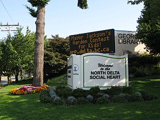
North Delta is a largely middle-class commuter town situated in the Lower Mainland, of British Columbia, Canada. The community is the most populous of the three communities that make up the City of Delta. North Delta is home to numerous parks and recreational opportunities. Alongside North Delta is Burns Bog, the largest raised urban peat bog in North America. As well, Watershed Park provides walking and biking trails, home to many artesian aquifers. Besides this, North Delta is home to a large amount of green-space. As of the 2016 census, North Delta has a population of 56,017.

Anmore is a village municipality in Metro Vancouver, British Columbia, Canada. It is north of the city of Port Moody and along the shores of the Indian Arm. Anmore is one of three politically independent villages in the Greater Vancouver area, the others being its neighbour, Belcarra, and Lions Bay.

The 97 B-Line was an express bus line in Metro Vancouver, British Columbia, Canada. It connected Coquitlam Central station on the West Coast Express system to Lougheed Town Centre station on the SkyTrain system. It was operated by Coast Mountain Bus Company and funded by TransLink. Going west, the route went along Clarke Rd., St. John's St., Ioco Rd, Guildford Way and Pinetree Way, and served Burnaby, Port Moody, and Coquitlam. The 97 B-Line was discontinued on December 18, 2016, as part of the December 2016 TransLink seasonal bus service changes, many resulting from the opening of the Evergreen Extension of the Millennium Line. The line carried 10,750 passengers on weekdays in 2011.

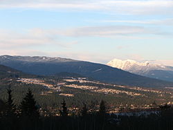
The Tri-Cities are an informal grouping of the three adjacent suburban cities of Coquitlam, Port Coquitlam, and Port Moody, along with the two villages of Anmore and Belcarra in the northeast sector of Metro Vancouver in British Columbia. Combined, these five communities have a 2016 population of 234,300 residents:

Downtown Vancouver is the main central business district and the city center neighbourhood of Metro Vancouver, located on the northwestern shore of the Burrard Peninsula in the Lower Mainland region of British Columbia. The Downtown occupies most of the north shore of the False Creek inlet, which incises into the Burrard Peninsula creating the namesaked Downtown Peninsula, where the West End neighbourhood and Stanley Park are also located.
The demographics of Metro Vancouver indicate a multicultural and multiracial region. Metro Vancouver is a metropolitan area, with its major urban centre being Vancouver, British Columbia, Canada. The Vancouver census metropolitan area, as defined by Statistics Canada, encompasses roughly the same territory as the Metro Vancouver Regional District, a regional district in British Columbia. The regional district includes 23 local authorities. Figures provided here are for the Vancouver census metropolitan area and not for the City of Vancouver.
Coquitlam Town Centre is the main commercial and retail neighbourhood for the city of Coquitlam, British Columbia. Coquitlam Town Centre covers 723 hectares. The Town Centre also contains the highest concentration of high-rise condominiums in the Tri-Cities and northeastern Metro Vancouver.

Maillardville is a community on the south slope of the city of Coquitlam, British Columbia, Canada.

Burquitlam is a neighbourhood and commercial district of the City of Coquitlam, British Columbia, Canada.