Burnaby is a city in the Lower Mainland region of British Columbia, Canada. Located in the centre of the Burrard Peninsula, it neighbours the City of Vancouver to the west, the District of North Vancouver across the confluence of the Burrard Inlet with its Indian Arm to the north, Port Moody and Coquitlam to the east, New Westminster and Surrey across the Fraser River to the southeast, and Richmond on the Lulu Island to the southwest.

Coquitlam is a city in the Lower Mainland of British Columbia, Canada. Mainly suburban, Coquitlam is the sixth-largest city in the province, with a population of 148,625 in 2021, and one of the 21 municipalities comprising Metro Vancouver. The mayor is Richard Stewart.

Port Coquitlam is a city in British Columbia, Canada. Located 27 km (17 mi) east of Vancouver, it is on the north bank of the confluence of the Fraser River and the Pitt River. Coquitlam borders it on the north, the Coquitlam River borders it on the west, and the city of Pitt Meadows lies across the Pitt River from it. Port Coquitlam is bisected by Lougheed Highway and the Canadian Pacific Railway. Port Coquitlam is often referred to as "PoCo". It is Canada's 93rd-largest municipality by population.
Metropolis at Metrotown is a three-storey shopping mall complex in the Metrotown area of Burnaby, British Columbia, Canada. Opened in 1986, it is the largest mall in British Columbia and the third-largest in Canada, behind Alberta's West Edmonton Mall and Ontario's Square One Shopping Centre, with 27 million customer visits annually. The mall is located adjacent to Metrotown station on the SkyTrain rapid transit system. Three office buildings are part of the complex along Central Boulevard.

Westwood Plateau is a neighbourhood in the northern region of Coquitlam, British Columbia.

The Evergreen Extension is a 10.9-kilometre-long (6.8 mi) extension of the Millennium Line of Metro Vancouver's SkyTrain rapid transit system. The extension runs from Lougheed Town Centre in Burnaby to Lafarge Lake–Douglas in Coquitlam and included six new SkyTrain stations and an upgraded existing station on the Millennium Line. It began operations on December 2, 2016.

The 97 B-Line was an express bus line in Metro Vancouver, British Columbia, Canada. It connected Coquitlam Central station on the West Coast Express system to Lougheed Town Centre station on the SkyTrain system. It was operated by Coast Mountain Bus Company and funded by TransLink. Going west, the route went along Clarke Rd., St. John's St., Ioco Rd, Guildford Way and Pinetree Way, and served Burnaby, Port Moody, and Coquitlam. The 97 B-Line was discontinued on December 18, 2016, as part of the December 2016 TransLink seasonal bus service changes, many resulting from the opening of the Evergreen Extension of the Millennium Line. The line carried 10,750 passengers on weekdays in 2011.

The Tri-Cities are an informal grouping of the three adjacent suburban cities of Coquitlam, Port Coquitlam, and Port Moody, along with the two villages of Anmore and Belcarra in the northeast sector of Metro Vancouver in British Columbia. Combined, these five communities have a 2016 population of 234,300 residents:

Downtown Vancouver is the central business district and the city centre neighbourhood of Vancouver, Canada, on the northwestern shore of the Burrard Peninsula in the Lower Mainland region of British Columbia. It occupies most of the north shore of the False Creek inlet, which cuts into the Burrard Peninsula creating the Downtown Peninsula, where the West End neighbourhood and Stanley Park are also located.

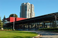
Coquitlam Central station is an intermodal rapid transit station in Metro Vancouver served by both the Millennium Line—part of the SkyTrain system—and the region's West Coast Express commuter rail system. The station is located on the north side of the Canadian Pacific Railway (CPR) tracks in Coquitlam, just west of the Lougheed Highway rail overpass, near the Coquitlam Centre shopping mall. 601 parking spaces are available on site. All services are operated by TransLink.

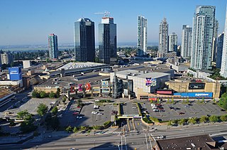
Coquitlam Centre is a shopping mall in Coquitlam, British Columbia, Canada, built in 1979 and expanded in 2001. It is located at the southern edge of the Coquitlam Town Centre area, near Coquitlam Central station and several other smaller shopping centres. Coquitlam Centre is the largest mall in the Tri-Cities area, with an area of 84,882 square metres (913,665 sq ft) and 200 stores and services.

Willowbrook Shopping Centre is a shopping centre in the Fraser Valley area of Metro Vancouver, Canada. Situated on Fraser Highway at Highway 10, Willowbrook is located between the City of Langley and Langley Township in British Columbia. The mall is 40 minutes southeast of Vancouver. As of January 2021, Willowbrook Shopping Centre has over 60,064 square metres (646,520 sq ft) of retail space.

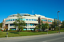
Coquitlam Public Library is a public library that serves Coquitlam, British Columbia.
Lafarge Lake–Douglas is a rapid transit station on the Millennium Line, part of Metro Vancouver's SkyTrain system, which serves as the line's outbound terminus. It is located in Coquitlam, British Columbia, Canada and opened for service on December 2, 2016, along with the rest of the Evergreen Extension.
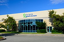
Town Centre Park is a park in central Coquitlam, British Columbia, just north of the Coquitlam Centre shopping mall. The park is surrounded by Coquitlam's city hall, main police station, main fire hall, City Centre Aquatic Complex, and the David Lam campus of Douglas College, Pinetree Secondary School, as well as many houses and apartments.
The SkyTrain rapid transit system in Greater Vancouver, Canada, was conceived as a legacy project of Expo 86 and was finished in time to showcase the fair's theme: "Transportation and Communication: World in Motion – World in Touch". Construction was funded by the provincial and federal governments. Vancouver had plans as early as the 1950s to build a monorail system, with modernist architect Wells Coates pencilled in to design it; that project was abandoned. The lack of a rapid transit system was said to be the cause of traffic problems in the 1970s, and the municipal government could not fund the construction of such a system. During the same period, Urban Transportation Development Corporation, then an Ontario crown corporation, was developing a new rapid transit technology known as an "Intermediate Capacity Transit System". In 1980, the need for rapid transit was great, and Ontario needed buyers for its new technology. "Advanced Rapid Transit" was selected to be built in Vancouver to showcase the Ontario project at Expo 86.

Lincoln is an elevated station on the Millennium Line of Metro Vancouver's SkyTrain rapid transit system in Coquitlam, British Columbia. It is located on Pinetree Way, situated between Lincoln and Northern Avenues. Coquitlam Centre and Henderson Place shopping centres are located within walking distance from the station.

Metrotown is a town centre serving the southwest quadrant of Burnaby, British Columbia, Canada. It is one of the city's four officially designated town centres, as well as one of Metro Vancouver's regional town centres. It is the central business district of the City of Burnaby.

Henderson Place Mall is a Chinese themed mall in the Town Centre area of Coquitlam, British Columbia. It is located on Pinetree Way across from Coquitlam Centre and Lincoln Station of the Millennium Line. Opened in 1999, it has 245,000 square feet of retail space