The Sacramento River is the principal river of Northern California in the United States and is the largest river in California. Rising in the Klamath Mountains, the river flows south for 400 miles (640 km) before reaching the Sacramento–San Joaquin River Delta and San Francisco Bay. The river drains about 26,500 square miles (69,000 km2) in 19 California counties, mostly within the fertile agricultural region bounded by the Coast Ranges and Sierra Nevada known as the Sacramento Valley, but also extending as far as the volcanic plateaus of Northeastern California. Historically, its watershed has reached as far north as south-central Oregon where the now, primarily, endorheic (closed) Goose Lake rarely experiences southerly outflow into the Pit River, the most northerly tributary of the Sacramento.

The Central Valley Project (CVP) is a federal power and water management project in the U.S. state of California under the supervision of the United States Bureau of Reclamation (USBR). It was devised in 1933 in order to provide irrigation and municipal water to much of California's Central Valley—by regulating and storing water in reservoirs in the northern half of the state, and transporting it to the water-poor San Joaquin Valley and its surroundings by means of a series of canals, aqueducts and pump plants, some shared with the California State Water Project (SWP). Many CVP water users are represented by the Central Valley Project Water Association.

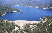
Shasta Dam is a concrete arch-gravity dam across the Sacramento River in Northern California in the United States. At 602 feet (183 m) high, it is the eighth-tallest dam in the United States. Located at the north end of the Sacramento Valley, Shasta Dam creates Shasta Lake for long-term water storage, flood control, hydroelectricity and protection against the intrusion of saline water. The largest reservoir in the state, Shasta Lake can hold about 4,500,000 acre-feet (5,600 GL).

The Pit River is a major river draining from northeastern California into the state's Central Valley. The Pit, the Klamath and the Columbia are the only three rivers in the U.S. that cross the Cascade Range.

The Trinity River is a major river in northwestern California in the United States and is the principal tributary of the Klamath River. The Trinity flows for 165 miles (266 km) through the Klamath Mountains and Coast Ranges, with a watershed area of nearly 3,000 square miles (7,800 km2) in Trinity and Humboldt Counties. Designated a National Wild and Scenic River, along most of its course the Trinity flows swiftly through tight canyons and mountain meadows.
Shasta Lake, also popularly known as Lake Shasta, is a reservoir in Shasta County, California, United States. It began to store water in 1944 due to the impounding of the Sacramento River by Shasta Dam, the ninth tallest dam in the United States.

The Colorado–Big Thompson Project is a federal water diversion project in Colorado designed to collect West Slope mountain water from the headwaters of the Colorado River and divert it to Colorado's Front Range and plains. In Colorado, approximately 80% of the state's precipitation falls on the West Slope, in the Rocky Mountains, while around 80% of the state's growing population lives along the eastern slope, between the cities of Fort Collins and Pueblo.

Clear Creek is a tributary of the upper Sacramento River in northern California.

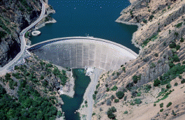
Trinity Dam is an earthfill dam on the Trinity River located about 7 miles (11 km) northeast of Weaverville, California in the United States. The dam was completed in the early 1960s as part of the federal Central Valley Project to provide irrigation water to the arid San Joaquin Valley.

The California State Water Project, commonly known as the SWP, is a state water management project in the U.S. state of California under the supervision of the California Department of Water Resources. The SWP is one of the largest public water and power utilities in the world, providing drinking water for more than 27 million people and generating an average of 6,500 GWh of hydroelectricity annually. However, as it is the largest single consumer of power in the state itself, it has a net usage of 5,100 GWh.

The Whiskeytown–Shasta–Trinity National Recreation Area is a United States National Recreation Area in northern California. The recreation area was authorized in 1965 by the United States Congress. Recreational activities available include swimming, fishing, boating, camping, and hiking.

Whiskeytown Lake is a reservoir in Shasta County in northwestern California, United States, about 8 miles (13 km) west of Redding. The lake is in the Whiskeytown Unit of the Whiskeytown-Shasta-Trinity National Recreation Area.
Monticello Dam is a 304-foot (93 m) high concrete arch dam in Napa County, California, United States, constructed between 1953 and 1957. The dam impounded Putah Creek to create Lake Berryessa in the Vaca Mountains.

Auburn Dam was a proposed concrete arch dam on the North Fork of the American River east of the town of Auburn, California, in the United States, on the border of Placer and El Dorado Counties. Slated to be completed in the 1970s by the U.S. Bureau of Reclamation, it would have been the tallest concrete dam in California and one of the tallest in the United States, at a height of 680 feet (210 m) and storing 2,300,000 acre-feet (2.8 km3) of water. Straddling a gorge downstream of the confluence of the North and Middle Forks of the American River and upstream of Folsom Lake, it would have regulated water flow and provided flood control in the American River basin as part of Reclamation's immense Central Valley Project.

Spring Creek Debris Dam is an earthfill dam on Spring Creek, a tributary of the Sacramento River, in Shasta County in the U.S. state of California. Completed in 1963, the dam, maintained by the U.S. Bureau of Reclamation, serves primarily to collect severe acid mine drainage stemming from the Iron Mountain Mine. The dam forms the Spring Creek Reservoir, less than 1 mile (1.6 km) long. Spring Creek and South Fork Spring Creek flow into the reservoir from a 16-square-mile (41 km2) watershed. The dam is directly upstream from the city of Keswick, California and the Keswick Reservoir. The operation is part of the Trinity River Division of the Central Valley Project.

The Spring Creek Reservoir is the artificial lake created by the construction of the Spring Creek Dam across Spring Creek in the Shasta-Trinity National Forest of Shasta County, California, adjacent to Keswick.

The Klamath Diversion was a federal water project proposed by the U.S. Bureau of Reclamation in the 1950s. It would have diverted the Klamath River in Northern California to the more arid central and southern parts of that state. It would relieve irrigation water demand and groundwater overdraft in the Central Valley and boost the water supply for Southern California. Through the latter it would allow for other Southwestern states—Arizona, Nevada, New Mexico and Utah—as well as Mexico to receive an increased share of the waters of the Colorado River.
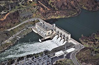
Keswick Dam is a concrete gravity dam on the Sacramento River about 2 miles (3.2 km) northwest of Redding, California. Part of the U.S. Bureau of Reclamation's Central Valley Project, the dam is 157 feet (48 m) high and impounds the Keswick Reservoir, which has a capacity of 23,800 acre⋅ft (29,400,000 m3). The dam's power plant has three turbines with a generating capacity of 117 megawatts (MW), which, in 1992, was uprated from its original 75 MW. The dam and reservoir serve as an afterbay to regulate peaking power releases from the Shasta Dam upstream.

Red Bluff Diversion Dam is a disused irrigation diversion dam on the Sacramento River in Tehama County, California, United States, southeast of the city of Red Bluff. Until 2013, the dam provided irrigation water for two canals that serve 150,000 acres (61,000 ha) of farmland on the west side of the Sacramento Valley. The dam and canals are part of the Sacramento Canals Unit of the Central Valley Project, operated by the U.S. Bureau of Reclamation. In 2013, the dam was decommissioned and the river allowed to flow freely through the site in order to protect migrating fish. A pumping plant constructed a short distance upstream now supplies water to the canal system.