
The Sacramento River is the principal river of Northern California in the United States and is the largest river in California. Rising in the Klamath Mountains, the river flows south for 400 miles (640 km) before reaching the Sacramento–San Joaquin River Delta and San Francisco Bay. The river drains about 26,500 square miles (69,000 km2) in 19 California counties, mostly within the fertile agricultural region bounded by the Coast Ranges and Sierra Nevada known as the Sacramento Valley, but also extending as far as the volcanic plateaus of Northeastern California. Historically, its watershed has reached as far north as south-central Oregon where the now, primarily, endorheic (closed) Goose Lake rarely experiences southerly outflow into the Pit River, the most northerly tributary of the Sacramento.

The San Joaquin River is the longest river of Central California. The 366-mile (589 km) long river starts in the high Sierra Nevada, and flows through the rich agricultural region of the northern San Joaquin Valley before reaching Suisun Bay, San Francisco Bay, and the Pacific Ocean. An important source of irrigation water as well as a wildlife corridor, the San Joaquin is among the most heavily dammed and diverted of California's rivers.
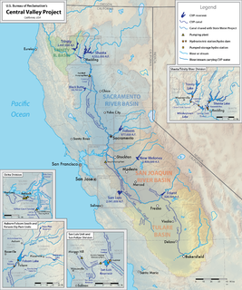
The Central Valley Project (CVP) is a federal power and water management project in the U.S. state of California under the supervision of the United States Bureau of Reclamation (USBR). It was devised in 1933 in order to provide irrigation and municipal water to much of California's Central Valley—by regulating and storing water in reservoirs in the northern half of the state, and transporting it to the water-poor San Joaquin Valley and its surroundings by means of a series of canals, aqueducts and pump plants, some shared with the California State Water Project (SWP). Many CVP water users are represented by the Central Valley Project Water Association.

The Governor Edmund G. Brown California Aqueduct is a system of canals, tunnels, and pipelines that conveys water collected from the Sierra Nevada Mountains and valleys of Northern and Central California to Southern California. Named after California Governor Edmund Gerald "Pat" Brown Sr., the over 400-mile (640 km) aqueduct is the principal feature of the California State Water Project.

The Sacramento–San Joaquin River Delta, or California Delta, is an expansive inland river delta and estuary in Northern California. The Delta is formed at the western edge of the Central Valley by the confluence of the Sacramento and San Joaquin rivers and lies just east of where the rivers enter Suisun Bay, which flows into San Francisco Bay and then the Pacific Ocean via San Pablo Bay. The Delta is recognized for protection by the California Bays and Estuaries Policy. Sacramento–San Joaquin Delta was designated a National Heritage Area on March 12, 2019. The city of Stockton is located on the San Joaquin River on the eastern edge of the delta. The total area of the Delta, including both land and water, is about 1,100 square miles (2,800 km2). Its population is around 500,000 residents.

The Yolo Bypass is one of the two flood bypasses in California's Sacramento Valley located in Yolo and Solano Counties. Through a system of weirs, the bypass diverts floodwaters from the Sacramento River away from the state's capital city of Sacramento and other nearby riverside communities.
The Delta–Mendota Canal is a 117-mile-long (188 km) aqueduct in central California, United States. The canal was designed and completed in 1951 by the U.S. Bureau of Reclamation as part of the Central Valley Project to supply freshwater to users downstream of the San Joaquin River. Freshwater is diverted into the Madera Canal and Friant-Kern Canal at Friant Dam.

Friant Dam is a concrete gravity dam on the San Joaquin River in central California in the United States, on the boundary of Fresno and Madera Counties. It was built between 1937 and 1942 as part of a U.S. Bureau of Reclamation (USBR) water project to provide irrigation water to the southern San Joaquin Valley. The dam impounds Millerton Lake, a 4,900-acre (2,000 ha) reservoir about 15 miles (24 km) north of Fresno.

San Luis Dam is a major earth-filled dam in Merced County, California, which forms San Luis Reservoir, the largest off-stream reservoir in the United States. The dam and reservoir are located in the Diablo Range to the east of Pacheco Pass and about 10 miles (16 km) west of Los Banos. San Luis Dam, a jointly-owned state and federal facility, stores more than 2 million acre feet (2.5 km3) of water for the California State Water Project and the federal Central Valley Project. Although the dam is located in the valley of San Luis Creek, the majority of its water comes from man-made aqueducts which are supplied from other rivers in Northern California.

The California State Water Project, commonly known as the SWP, is a state water management project in the U.S. state of California under the supervision of the California Department of Water Resources. The SWP is one of the largest public water and power utilities in the world, providing drinking water for more than 23 million people and generating an average of 6,500 GWh of hydroelectricity annually. However, as it is the largest single consumer of power in the state itself, it has a net usage of 5,100 GWh.

Millerton Lake is an artificial lake near the town of Friant about 15 mi (24 km) north of downtown Fresno. The reservoir was created by the construction of 319 ft high Friant Dam on the San Joaquin River which, with the lake, serves as much of the county line between Fresno County to the south and Madera County to the north.
The Harvey O. Banks Pumping Plant is located 2.5 miles (4 km) southwest of the Clifton Court Forebay and 12 miles (19 km) northwest of Tracy, CA. The plant is the first pumping plant for the California Aqueduct and the South Bay Aqueduct. It provides the necessary fluid head for the California Aqueduct to flow for approximately 80 miles (130 km) south past the O'Neill Forebay and the San Luis Reservoir to the Dos Amigos Pumping Plant. The Banks Pumping Plant initially flows into the Bethany Reservoir. It is from the Bethany Reservoir that the South Bay Aqueduct begins.
The Peripheral Canal was a series of proposals starting in the 1940s to divert water from California's Sacramento River, around the periphery of the San Joaquin-Sacramento River Delta, to uses farther south. The canal would have attempted to resolve a problem with the quality of water pumped south. Pumps create such a powerful suction that the boundary between freshwater to saltwater has shifted inland, negatively affecting the environment. The pumps have increased by 5 to 7 million acre-feet the amount of water exported each year to the Central Valley and Southern California. However, the peripheral canal as proposed would have reduced the overall freshwater flow into the Delta and move the freshwater-saltwater interface further inland, causing damage to Delta agriculture and ecosystems.

The Friant-Kern Canal is a 152 mi (245 km) aqueduct managed by the United States Bureau of Reclamation in Central California to convey water to augment irrigation capacity in Fresno, Tulare, and Kern counties. A part of the Central Valley Project, canal construction began in 1949 and was completed in 1951 at a cost of $60.8 million.

The Oroville–Thermalito Complex is a group of reservoirs, structures, and facilities located in and around the city of Oroville in Butte County, California. The complex serves not only as a regional water conveyance and storage system, but is the headwaters for, and therefore perhaps is the most vital part of, the California Department of Water Resources' State Water Project, the world's largest publicly built and operated water and power development and conveyance system.

Sites Reservoir is a proposed $5.2-billion offstream reservoir project west of Colusa in the Sacramento Valley of northern California, to be built by the California Department of Water Resources. The project would pump 470,000 to 640,000 acre-feet per year of the winter flood flow from the Sacramento River upstream of the Sacramento–San Joaquin River Delta, through existing canals to an artificial lake 14 miles (23 km) away. Annual yield will depend on precipitation and environmental restrictions.
California Water Fix and Eco Restore, formerly known as the Bay Delta Conservation Plan, is a $15 billion plan proposed by Governor Jerry Brown and the California Department of Water Resources to build two large, four-story tall tunnels to carry fresh water from the Sacramento River under the Sacramento-San Joaquin Delta toward the intake stations for the State Water Project and the Central Valley Project.

Red Bluff Diversion Dam is a disused irrigation diversion dam on the Sacramento River in Tehama County, California, United States, southeast of the city of Red Bluff. Until 2013, the dam provided irrigation water for two canals that serve 150,000 acres (61,000 ha) of farmland on the west side of the Sacramento Valley. The dam and canals are part of the Sacramento Canals Unit of the Central Valley Project, operated by the U.S. Bureau of Reclamation. In 2013, the dam was decommissioned and the river allowed to flow freely through the site in order to protect migrating fish. A pumping plant constructed a short distance upstream now supplies water to the canal system.

The Old River is a tidal distributary of the San Joaquin River that flows for about 40 miles (64 km) through the Sacramento–San Joaquin River Delta in Northern California. The Old River was once the main channel of the San Joaquin until navigation and flood control projects in the late 19th and 20th century fixed the San Joaquin to its present course past Stockton. It diverges from the San Joaquin near Tracy, about 38 miles (61 km) upstream from Antioch, and first runs west towards Mountain House, then north to rejoin the San Joaquin 13 miles (21 km) above Antioch. The river is lined with levees that prevent flooding of the adjacent Delta islands, many of which lie below sea level. The Middle River runs east of and roughly parallel to Old River. False River diverges from Old River about a mile (1.6 km) above the Old River's mouth and runs westward to join the San Joaquin at a point closer to Antioch. Part of the Old River forms the boundary between San Joaquin County on the east and Contra Costa County to the west.

The C.W. Bill Jones Pumping Plant located 9 miles northwest of Tracy, CA, was constructed between 1947 and 1951, and is a key component of the Central Valley Project. The Delta Cross Channel intercepts Sacramento River water as it travels westwards towards Suisun Bay and diverts it south through a series of man-made channels, the Mokelumne River, and other natural sloughs, marshes and distributaries. From there, the water travels to the C.W. Bill Jones Pumping Plant, which raises water into the Delta-Mendota Canal, which in turn travels 117 miles (188 km) southwards to Mendota Pool on the San Joaquin River, supplying water to other CVP reservoirs about midway. The Tracy Fish Collection Facility exists at the entrance of the pump plant in order to catch fish that would otherwise end up in the Delta-Mendota Canal.


