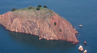
Red Rock Island is an uninhabited, 5.8-acre (2.3 ha) island in the San Francisco Bay located just south of the Richmond–San Rafael Bridge. The property is the only privately owned island in San Francisco Bay. The boundaries of three counties – San Francisco, Marin, and Contra Costa – converge on the island. The San Francisco County portion is an incorporated part of the city of San Francisco since it is a consolidated city-county; the Contra Costa portion is incorporated inside the city limits of Richmond.

The Brothers are a pair of small islands, East Brother and West Brother, located in the San Rafael Bay embayment of San Pablo Bay, these roughly 1,000 feet (300 m) west of Point San Pablo in Contra Costa County, California.

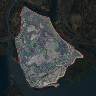
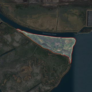
Browns Island is a regional preserve of the East Bay Regional Park District (EBRPD) in Pittsburg, Contra Costa County, California, United States. It is an island in Suisun Bay, part of the Sacramento-San Joaquin River Delta, separated from the rest of Pittsburg by New York Slough.

Roe Island is an island in Suisun Bay at the mouth of the Sacramento-San Joaquin River Delta in Solano County, California, 10 km east of Benicia. Its western tip is named Preston Point, and its eastern tip is Gillespie Point. It is shown, labeled "Preston Island", on an 1850 survey map of the San Francisco Bay area made by Cadwalader Ringgold and an 1854 map of the area by Henry Lange. It is labeled, along with Deadman Island, Joice Island, Grizzly Island, Simmons Island and Ryer Island, on a 1902 USGS map of the area.
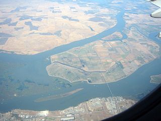
Sherman Island is an island in the Sacramento-San Joaquin River Delta at the confluence of the two rivers in Sacramento County, California, 1.2 miles (1.9 km) northeast of Antioch. The 5,500 ha island, mostly managed by Reclamation District 341, is the meeting point of Sacramento, Solano, and Contra Costa Counties, and is bordered on the north and northwest by the Sacramento River, on the northeast by Three Mile Slough, and on the east, and south west by the San Joaquin River. Sherman Island is a widely known kite and windsurfing area.

Grand Island is an island lying between Sycamore Slough and the Sacramento River. A post office operated at Grand Island from 1854 to 1919. It is shown, labeled "Taylor Island", on an 1850 survey map of the San Francisco Bay area made by Cadwalader Ringgold and an 1854 map of the area by Henry Lange.
Ryer Island is an island in Suisun Bay at the mouth of the Sacramento-San Joaquin River Delta in Solano County, California, eight miles east-northeast of Benicia. It is administered by Reclamation District 501, and is in the Suisun Resource Conservation District. At the time of statehood it was known as Kings Island, and is labeled as such on an 1850 survey map of the San Francisco Bay area made by Cadwalader Ringgold as well as an 1854 map of the area by Henry Lange. It is labeled, along with Deadman Island, Joice Island, Grizzly Island, Simmons Island, and Roe Island, on a 1902 USGS map of the area.

Hammond Island is a small island in Suisun Bay, California. It is part of Solano County. Its coordinates are 38°06′18″N121°56′15″W. An 1850 survey map of the San Francisco Bay area made by Cadwalader Ringgold shows islands partially covering some of the current area of Hammond Island, labeled "Davis Island" and "Warrington Island".

Chipps Island is a small island in Suisun Bay, California. It is part of Solano County. It is also known as Knox Island, Its coordinates are 38°03′19″N121°54′43″W by which name it appears on an 1850 survey map of the San Francisco Bay area made by Cadwalader Ringgold, as well as an 1854 map of the area by Henry Lange. In 1959, the state of California used Chipps Island in a legal definition of the western boundary of the Sacramento–San Joaquin River Delta.
Dutton Island is a small island in Suisun Bay, California. It is part of Solano County, and included within Reclamation District 2127. Its coordinates are 38°04′54″N121°58′14″W. An 1850 survey map of the San Francisco Bay area made by Cadwalader Ringgold, as well as an 1854 map of the area by Henry Lange, shows an unlabeled island covering some of the area now occupied by Dutton Island.

Grizzly Island is a small island in Grizzly Bay in the San Francisco Bay Area of California. It is part of Solano County, partially managed by Reclamation Districts 2112, 2129 and 2136. Its coordinates are 38°09′05″N121°58′22″W. Islands that partially cover some of its current area, labelled "Warrington Island" and "Davis Island", are shown on an 1850 survey map of the San Francisco Bay area made by Cadwalader Ringgold and an 1854 map of the area by Henry Lange. It is labeled, along with Deadman Island, Joice Island, Simmons Island, Ryer Island and Roe Island, on a 1902 USGS map of the area.

Simmons Island is a small island in Grizzly Bay in the San Francisco Bay Area of California. It is part of Solano County, and included within Reclamation District 2127. Its coordinates are 38°05′49″N121°59′26″W. It is shown as "Simmons Island" on an 1850 survey map of the San Francisco Bay area made by Cadwalader Ringgold, and as "Simons Island" on an 1854 map of the area by Henry Lange. It is labeled, along with Deadman Island, Joice Island, Grizzly Island, Ryer Island and Roe Island, on a 1902 USGS map of the area.

Wheeler Island is a small island in Suisun Bay, California. It is part of Solano County; parts of it are included in Reclamation Districts 2127 and 2130. Its coordinates are 38°05′06″N121°56′15″W. An 1850 survey map of the San Francisco Bay area made by Cadwalader Ringgold, and an 1854 map by Henry Lange, show islands partially covering some of the current area of Wheeler Island, labeled "Davis Island" and "Warrington Island".
Sutter Island is a small island of the Sacramento River in California. It is bordered by the Sacramento River on the northeast, Steamboat Slough to the southease, and Sutter Slough to the west. It is located across the Sacramento River from Paintersville. It is part of Sacramento County, and managed by Reclamation District 349. Its coordinates are 38°17′37″N121°35′32″W. It is shown, labeled "Schoolcraft Island", on an 1850 survey map of the San Francisco Bay area made by Cadwalader Ringgold and an 1854 map of the area by Henry Lange.
West Island is a small island in the San Joaquin River, California. It is part of Sacramento County. Its coordinates are 38°01′24″N121°46′43″W. It is shown, labeled "Webers Island", on an 1850 survey map of the San Francisco Bay area made by Cadwalader Ringgold and an 1854 map of the area by Henry Lange.

Brannan Island is a small island in the Sacramento–San Joaquin River Delta. It is part of Sacramento County, California, and is managed by Reclamation District 2067. Its coordinates are 38°07′19″N121°38′37″W, and the United States Geological Survey measured its elevation as −13 ft (−4.0 m) in 1981. A "Brannan Island", with the same location but a slightly different shape, is labeled on an 1850 survey map of the San Francisco Bay area made by Cadwalader Ringgold as well as an 1854 map of the area by Henry Lange.

Kimball Island is a small island in the Sacramento–San Joaquin River Delta. It is located in Sacramento County, California, in the United States. Since its discovery, it has been used to grow barley, farm fish, cultivate cannabis, and as residential land. Currently, however, it is uninhabited; since 2000, it has been left to "forever be a wetland habitat", and is sometimes used as a fishing spot.

Montezuma Island is an island in Suisun Bay, an embayment of San Francisco Bay, and downstream of the Sacramento–San Joaquin River Delta. It is part of Sacramento County, California, and not managed by any reclamation district. Its coordinates are 38°04′28″N121°50′23″W, and the United States Geological Survey measured its elevation as 7 ft (2.1 m) in 1981. It is labeled "Burnett Island" on an 1850 survey map of the San Francisco Bay area made by Cadwalader Ringgold, and shown (unlabeled) on an 1854 map of the area by Henry Lange.
Spinner Island is an island in Suisun Bay, an embayment of San Francisco Bay, downstream of the Sacramento–San Joaquin River Delta. It is part of Solano County, California, and not managed by any reclamation district. Its coordinates are 38°04′11″N121°52′10″W, and the United States Geological Survey measured its elevation as 0 ft (0 m) in 1981. It is shown in an 1850 survey map of the San Francisco Bay area made by Cadwalader Ringgold, as well as an 1854 map of the area by Henry Lange.

Randall Island is an island in the Sacramento River, in the Sacramento–San Joaquin River Delta. It is part of Sacramento County, California, and managed by Reclamation District 755. Its coordinates are 38°20′25″N121°33′03″W, and the United States Geological Survey measured its elevation as 0 ft (0 m) in 1981. It is shown, labelled "Hensley Island", on an 1850 survey map of the San Francisco Bay area made by Cadwalader Ringgold and an 1854 map of the area by Henry Lange.


