Chain Island

Last updated

Chain Island
NASA Worldwind, USGS imagery map, Chain Island, California.png
USGS aerial imagery of Chain Island
Sacramento-San Joaquin Delta OSM Cycle Large.png
Red pog.svg
Chain Island
USA California location map.svg
Red pog.svg
Chain Island
Usa edcp location map.svg
Red pog.svg
Chain Island
Geography
Location Northern California
Coordinates 38°04′11″N121°51′11″W / 38.06972°N 121.85306°W / 38.06972; -121.85306 (Chain Island) [1] Coordinates: 38°04′11″N121°51′11″W / 38.06972°N 121.85306°W / 38.06972; -121.85306 (Chain Island) [1]
Adjacent to Sacramento–San Joaquin River Delta
Area41.81 acres (16.92 ha) [2]
Highest elevation0 ft (0 m) [1]
Administration
United States
StateFlag of California.svg  California
County Sacramento
An aerial photo taken looking north in 2015. Chain Island can be seen on the left, west of Montezuma Island. Rio-Vista-Montezuma-Hills-Wind-Farms-1 (cropped to Montezuma and Chain islands).jpg
An aerial photo taken looking north in 2015. Chain Island can be seen on the left, west of Montezuma Island.

Chain Island is an island in Suisun Bay, downstream of the Sacramento–San Joaquin River Delta in northern California, and the westernmost piece of land in Sacramento County. In the late 1800s, it was considered an "obstruction to navigation" on the Sacramento River. As it was built up significantly from hydraulic mining tailings upstream on the river, plans were made in the early 20th century to remove it and recoup costs by mining the debris. However, this never happened; it was sold by the California State Lands Commission to a private individual in 1959, who listed it for sale the next year. In April 2016, the deed for the island was transferred; as of December 2022, Sacramento County assesses its land value at $18,622.

Contents

Geography

Chain Island's coordinates are 38°04′11″N121°51′11″W / 38.06972°N 121.85306°W / 38.06972; -121.85306 (Chain Island) . [1] Sacramento County assesses the island as parcel #15801200070000, with an area of 41.81 acres (16.92 ha). [2] It is located in the Sacramento River, past the southeastern end of the Sacramento River Deep Water Ship Channel, at its confluence with the San Joaquin River from the south (via Broad Slough) and immediately upstream of Suisun Bay (an embayment of San Francisco Bay). [3] [4] To its northeast are Montezuma Island and Collinsville on the mainland; to its west is Spinner Island (and past that, Van Sickle Island). [3] To its south are Winter Island and Browns Island, which are separated by New York Slough from the city of Pittsburg. [3]

Chain Island is the westernmost piece of land in Sacramento County (and nearly the southernmost; only the southern half of Sherman Island, Lobree Island, Kimball Island and West Island are further south). [5] :95 Approximately 1,000 ft (300 m) to its south is Contra Costa County, and approximately 100 ft (30 m) to its north and west is Solano County. [3]

The United States Geological Survey gave Chain Island's elevation as 0 ft (sea level) in 1981. [1] It is not managed by any reclamation district, [6] although it is designated by the State of California as a "significant natural area". [5] :95 Mason's ilaeopsis [lower-alpha 1] and Suisun marsh aster grow there. [5] :95 In 1994, it was reported by the Modesto Bee that large sturgeon were being caught at Chain Island; [7] in 1999 the Martinez News-Gazette said that "good numbers of striped bass" could be found near there. [8] In 2003, a 60 lb (27 kg), 63 in (1,600 mm) sturgeon was caught at Chain Island; [9] in 2006, a 53 lb (24 kg) sturgeon was caught there. [10] As of 2014, sturgeon fishing at Chain Island was still good. [11]

History

The first Europeans to document Chain Island's existence were the party of Cadwalader Ringgold, who made a survey of it (and other islands in the area) on an 1850 expedition. [12]

In 1902, plans were made for controlling flooding on the Sacramento and San Joaquin Rivers by straightening their channels to drain more quickly into the sea; Chain Island was one of many landforms in the path of this direct flow, and it was identified for removal. [13] In May 1903, the War Department awarded a contract to a company of what it called "California capitalists" for the removal of the island; at the time, it was surveyed as comprising 182 acres (74 ha) of land, and "an obstruction to navigation". [14] [15] The project had previously been supported by State of California engineers, but prohibitive costs prevented it from being undertaken. [16] The capitalists offered to perform the work free of charge, on the reasoning that gold from earlier large-scale hydraulic mining operations during the California gold rush would be found in the material removed. [14] As the Sacramento and San Joaquin drain large areas of California, "great mountains" of material had been washed into the river beds over time. [17] The removal of the island would, therefore, be combined with a placer mining operation to recoup the entire expense of removal. [18] [19] This included the cost of adhering to the War Department contract's "severe conditions", including transportation of all removed material "far up on the shore" to be impounded behind a dam (to prevent it from washing back into the river). [20] The project was endorsed by the State Auditing Board to the Commissioner of Public Works. [19] It was hypothesized that, if the project succeeded, corporations would be organized to "scoop out the entire river bed". [19] [17]

This project was never carried out. By December 1904, the Engineering Board at Sioux City, Iowa, outlined a plan for ameliorating flooding in the Sacramento–San Joaquin river system, in which it was announced that a number of "pet schemes" would "die after a more or less lengthy and sickly existence". [21] Chain Island was shown on a 1907 map made by the United States Geological Survey. [22] In 1918, a navigational buoy was installed to mark a shoal near Chain Island; [23] the buoy was discontinued in 1938. [24]

On January 26, 1959, a notice was made that the California State Lands Commission was offering Chain Island for sale in February; by then, its area was given as 41.81 acres (16.92 ha), and the minimum bid was $5,226.25 ($48,579 in 2021). [25] It was discovered that the plots from the original 1902 survey were significantly different from the actual location of the island in 1957, and California's attorney general determined that the island could be sold according to boundaries from the 1957 survey. [26] In February, the Sacramento County Board of Supervisors voted to inform the state of California that the county was "interested in the possible purchase of Chain Island in the delta area for a possible development as a park", and request that the sale be delayed for two weeks. [27] In March, however, the island was sold to Russell Gallaway III, a Sacramento businessman, who planned to use it as a "hunting and fishing retreat". He paid $5,258.20 for it ($48,877 in 2021). [26] The next year, an advertisement was placed offering the island (now claimed to have 58 acres (23 ha)) for sale for $7,500 ($68,698 in 2021). [28] In April 2016, the deed for the island was transferred. [2] As of December 2022, Sacramento County assesses its land value at $18,622. [2]

Notes

  1. The source discusses several islands in the area, and in every instance but one, it names "Mason's lilaeopsis," with an "L" at the beginning of the second word. Only once, when discussing Chain Island, does it refer to "Mason's ilaeopsis" without the "L." Presumably, that one instance is a typo.

Related Research Articles

<span class="mw-page-title-main">Ryer Island (Suisun Bay)</span>

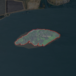
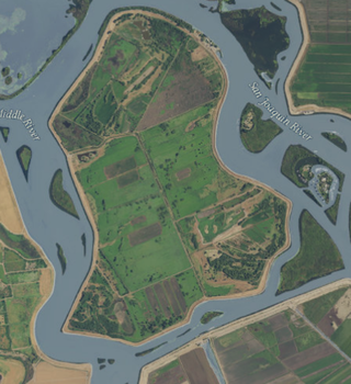
Ryer Island is an island in Suisun Bay at the mouth of the Sacramento-San Joaquin River Delta in Solano County, California, eight miles east-northeast of Benicia. It is administered by Reclamation District 501, and is in the Suisun Resource Conservation District. At the time of statehood it was known as Kings Island, and is labeled as such on an 1850 survey map of the San Francisco Bay area made by Cadwalader Ringgold as well as an 1854 map of the area by Henry Lange. It is labeled, along with Deadman Island, Joice Island, Grizzly Island, Simmons Island, and Roe Island, on a 1902 USGS map of the area.

<span class="mw-page-title-main">Joice Island</span> Island in California

Joice Island is a small island in Grizzly Bay in California. It is part of Suisun Marsh, and has been used for hunting since the late 19th century. After a failed attempt to reclaim the land for asparagus and alfalfa farming in the early 1900s, Joice Island spent several decades as a wildlife refuge before being opened to the public for hunting in 1964. Currently, the upper portion of Joice Island is part of the California Department of Fish and Wildlife's Grizzly Island Wildlife Area; fishing, as well as the hunting of waterfowl and pigs, is permitted there on a limited basis.

<span class="mw-page-title-main">Hammond Island (California)</span> Island in California

Hammond Island is a small island in Suisun Bay, California. It is part of Solano County. Its coordinates are 38°06′18″N121°56′15″W. An 1850 survey map of the San Francisco Bay area made by Cadwalader Ringgold shows islands partially covering some of the current area of Hammond Island, labeled "Davis Island" and "Warrington Island".

<span class="mw-page-title-main">Chipps Island</span> Island in California

Chipps Island is a small island in Suisun Bay, California. It is part of Solano County. It is also known as Knox Island, Its coordinates are 38°03′19″N121°54′43″W by which name it appears on an 1850 survey map of the San Francisco Bay area made by Cadwalader Ringgold, as well as an 1854 map of the area by Henry Lange. In 1959, the state of California used Chipps Island in a legal definition of the western boundary of the Sacramento–San Joaquin River Delta.

<span class="mw-page-title-main">Dutton Island</span> Island in California

Dutton Island is a small island in Suisun Bay, California. It is part of Solano County, and included within Reclamation District 2127. Its coordinates are 38°04′54″N121°58′14″W. An 1850 survey map of the San Francisco Bay area made by Cadwalader Ringgold, as well as an 1854 map of the area by Henry Lange, shows an unlabeled island covering some of the area now occupied by Dutton Island.

<span class="mw-page-title-main">Simmons Island</span> Island in California

Simmons Island is a small island in Grizzly Bay in the San Francisco Bay Area of California. It is part of Solano County, and included within Reclamation District 2127. Its coordinates are 38°05′49″N121°59′26″W. It is shown as "Simmons Island" on an 1850 survey map of the San Francisco Bay area made by Cadwalader Ringgold, and as "Simons Island" on an 1854 map of the area by Henry Lange. It is labeled, along with Deadman Island, Joice Island, Grizzly Island, Ryer Island and Roe Island, on a 1902 USGS map of the area.

<span class="mw-page-title-main">Wheeler Island (California)</span> Island in California

Wheeler Island is a small island in Suisun Bay, California. It is part of Solano County; parts of it are included in Reclamation Districts 2127 and 2130. Its coordinates are 38°05′06″N121°56′15″W. An 1850 survey map of the San Francisco Bay area made by Cadwalader Ringgold, and an 1854 map by Henry Lange, show islands partially covering some of the current area of Wheeler Island, labeled "Davis Island" and "Warrington Island".

<span class="mw-page-title-main">West Island (California)</span> Island in California

West Island is a small island in the San Joaquin River, California. It is part of Sacramento County. Its coordinates are 38°01′24″N121°46′43″W. It is shown, labeled "Webers Island", on an 1850 survey map of the San Francisco Bay area made by Cadwalader Ringgold and an 1854 map of the area by Henry Lange.

<span class="mw-page-title-main">Medford Island</span> Island in California

Medford Island is a small island in the San Joaquin River delta, in California. It is part of San Joaquin County, and managed by Reclamation District 2041. Its coordinates are 38.0371435°N 121.5113407°W.

<span class="mw-page-title-main">Headreach Island</span> Island in California

Headreach Island is a small island in the Sacramento–San Joaquin River Delta, in northern California. A naturally-formed island existing in a complex with Tule Island to the southeast and Fern Island to the northwest, it was used for farming as late as the 1920s. While several proposals for real estate development on the island were made in the late 20th century, it now consists mostly of marsh and submerged land. Black rails live on the island.

<span class="mw-page-title-main">Kimball Island</span> Island in California

Kimball Island is a small island in the Sacramento–San Joaquin River Delta. It is located in Sacramento County, California, in the United States. Since its discovery, it has been used to grow barley, farm fish, cultivate cannabis, and as residential land. Currently, however, it is uninhabited; since 2000, it has been left to "forever be a wetland habitat", and is sometimes used as a fishing spot.

<span class="mw-page-title-main">Mallard Island</span> Island in California

Mallard Island is a small island in Suisun Bay, at the confluence of the Sacramento and San Joaquin rivers. It is part of Contra Costa County, California. Its coordinates are 38°02′31″N121°55′07″W, and the United States Geological Survey measured its elevation as 3 ft (0.91 m) in 1981. It appears in a 1953 USGS map of the area.

<span class="mw-page-title-main">Spud Island</span> Island in California

Spud Island is a small island of the San Joaquin River, located in the Sacramento–San Joaquin River Delta in northern California. It was once used to farm onions; while it is no longer used for agriculture, it remains inhabited. In the late 20th century it was the site of a county park, which offered camping, fishing and swimming amenities free of charge.

<span class="mw-page-title-main">Tinsley Island</span> Island in California

Tinsley Island is a small island in the Sacramento–San Joaquin River Delta, in San Joaquin County, California, next to the Stockton Deepwater Shipping Channel. It was created in the 1930s, when dredging to improve the navigability of the San Joaquin River cut it off from Roberts Island. Since 1958, it has been owned by the St. Francis Yacht Club. In 1960, the club transported a lighthouse from San Francisco Bay to serve as its clubhouse, and in the same year began an annual "Stag Cruise"; as of 2021, the club still owns the island and maintains a clubhouse there.

<span class="mw-page-title-main">Tule Island</span> Island in California

Tule Island is a small island in the Sacramento–San Joaquin River Delta, which exists as part of a complex of islands including directly-adjacent Fern Island and Headreach Island. It is a naturally-formed island, which was used in the early 20th century to farm potatoes, but now consists mostly of marsh. It is currently a habitat for waterfowl and is used as a fishing spot.

<span class="mw-page-title-main">Empire Tract</span> Island in California

The Empire Tract is an island in the Sacramento–San Joaquin River Delta in San Joaquin County, California, United States. It has been used for agriculture since the 1800s; in the early 20th century it was used to plant potatoes, and United States president Herbert Hoover operated a beet farm there. In the 1960s, natural gas deposits were discovered beneath the island. In 1936, it was connected to the mainland by the Eight Mile Road Bridge, across King Island. As with many islands in the Delta, the Empire Tract has experienced considerable subsidence, and is well below sea level.

<span class="mw-page-title-main">Hog Island (San Joaquin County)</span> Island in California

Hog Island is an island in the San Joaquin River, and is one of many islands which constitute the Sacramento–San Joaquin River Delta. It was used for agriculture in the early 20th century, but has now mostly become marsh or submerged land; it remains a spot for fishing, particularly halibut and striped bass.

<span class="mw-page-title-main">Middle Ground Island</span> Island in California

Middle Ground Island is an island in Suisun Bay, an embayment of San Francisco Bay, downstream of the Sacramento–San Joaquin River Delta. It is part of Solano County, California, and not managed by any reclamation district. Its coordinates are 38°03′46″N121°58′53″W, and the United States Geological Survey measured its elevation as 0 ft (0 m) in 1981.

<span class="mw-page-title-main">Montezuma Island</span> Island in California

Montezuma Island is an island in Suisun Bay, an embayment of San Francisco Bay, and downstream of the Sacramento–San Joaquin River Delta. It is part of Sacramento County, California, and not managed by any reclamation district. Its coordinates are 38°04′28″N121°50′23″W, and the United States Geological Survey measured its elevation as 7 ft (2.1 m) in 1981. It is labeled "Burnett Island" on an 1850 survey map of the San Francisco Bay area made by Cadwalader Ringgold, and shown (unlabeled) on an 1854 map of the area by Henry Lange.

<span class="mw-page-title-main">Randall Island</span> Island in California

Randall Island is an island in the Sacramento River, in the Sacramento–San Joaquin River Delta. It is part of Sacramento County, California, and managed by Reclamation District 755. Its coordinates are 38°20′25″N121°33′03″W, and the United States Geological Survey measured its elevation as 0 ft (0 m) in 1981. It is shown, labelled "Hensley Island", on an 1850 survey map of the San Francisco Bay area made by Cadwalader Ringgold and an 1854 map of the area by Henry Lange.

References

  1. 1 2 3 4 5 "Feature Details: 220878". United States Geological Survey Geographic Names Information System. Retrieved 21 January 2022.
  2. 1 2 3 4 "Assessor Parcel Viewer, Sacramento County, California, USA". Sacramento County. Retrieved 6 December 2022.
  3. 1 2 3 4 Topography, State of California: Antioch North Quadrangle (Map). United States Geological Survey. 1973.
  4. California State Automobile Association (1999). San Francisco Bay Region (Map). 1:190,000. American Automobile Association.
  5. 1 2 3 County of Sacramento (2011). "General Plan: Conservation Element" (PDF).
  6. "Sacramento County, California Reclamation Districts" (PDF). Sacramento Local Agency Formation Commission. August 2009. Archived (PDF) from the original on 14 March 2021. Retrieved 24 February 2021.
  7. "Fishing Report: Delta (San Joaquin)". The Modesto Bee. Modesto, California. 3 November 1994. p. 22 via Newspapers.com.
  8. "Let's Go Fishing". Martinez News-Gazette. Martinez, California. 6 November 1999. p. 10 via Newspapers.com.
  9. "Project Kokanee Fun Fishing Derby opens June 7 at Lake Berryessa". The Napa Valley Register. Napa, California. 29 May 2003. p. 11 via Newspapers.com.
  10. "Fish Report: Delta". The Modesto Bee. Modesto, California. 22 February 2006. p. C3 via Newspapers.com.
  11. "Fishing Line: Top Picks". The Sacramento Bee. Sacramento, California. 29 October 2014. p. C9 via Newspapers.com.
  12. "The Trails Are Blazed..." The Sacramento Bee. Sacramento, California. 25 February 1957. p. 54 via Newspapers.com.
  13. "Plans Outlined for River Improvement". The Evening Mail. Stockton, California. 31 December 1902. p. 5 via Newspapers.com.
  14. 1 2 "To Remove Obstruction". The Sacramento Bee. Sacramento, California. 26 May 1903. p. 10 via Newspapers.com.
  15. "Will Remove Island". Oakland Tribune. Oakland, California. 26 May 1903. p. 3 via Newspapers.com.
  16. "Chain Island: Capitalists To Remove It". Los Angeles Times. Los Angeles, California. 27 May 1903. p. 3 via Newspapers.com.
  17. 1 2 "Where Would They Put The Sand?". Independent-Herald. Yuba City, California. 11 June 1903. p. 2 via Newspapers.com.
  18. "Think Island Rich In Gold". The Morning Union. Grass Valley, California. 27 May 1903. p. 1 via Newspapers.com.
  19. 1 2 3 "Will Mine an Island in the River". The Weekly Nugget. Placerville, California. 28 May 1903. p. 2 via Newspapers.com.
  20. "River Obstruction To Be Removed". San Francisco Chronicle. San Francisco, California. 27 May 1903. p. 3 via Newspapers.com.
  21. "Improving the Sacramento". The Sacramento Bee. Sacramento, California. 12 December 1904. p. 1. Retrieved 18 November 2021 via Newspapers.com.
  22. Douglas, E.M.; Marshall, R.B.; Stiles, Arthur; Nelson, C.L.; Vance, W.N.; Harrison, J.P.; Turner, P.E.; La Follette, R.M.; Knock, Bayard; Urquhart, C.F. (1907). Topography, State of California: Antioch Quadrangle (Map). United States Geological Survey.
  23. "Notice to Mariners". The San Francisco Examiner. San Francisco, California. 27 November 1918. p. 17 via Newspapers.com.
  24. "Notice to Mariners". Oakland Tribune. Oakland, California. 7 October 1938. p. 39 via Newspapers.com.
  25. "Sale of State Land". The Sacramento Bee. Sacramento, California. 26 January 1959. p. 24 via Newspapers.com.
  26. 1 2 "Sacramentan Purchases Misplaced Island In River". The Sacramento Bee. Sacramento, California. 25 March 1959. p. 19 via Newspapers.com.
  27. "The board also". The Sacramento Bee. Sacramento, California. 16 February 1959. p. 15 via Newspapers.com.
  28. "Duck Hunters". The San Francisco Examiner. San Francisco, California. 10 July 1960. p. 76 via Newspapers.com.