
The Rocky Mountains, also known as the Rockies, are a major mountain range and the largest mountain system in North America. The Rocky Mountains stretch 3,000 miles in straight-line distance from the northernmost part of western Canada, to New Mexico in the southwestern United States. Depending on differing definitions between Canada and the U.S., its northern terminus is located either in northern British Columbia's Terminal Range south of the Liard River and east of the Trench, or in the northeastern foothills of the Brooks Range/British Mountains that face the Beaufort Sea coasts between the Canning River and the Firth River across the Alaska-Yukon border. Its southernmost point is near the Albuquerque area adjacent to the Rio Grande rift and north of the Sandia–Manzano Mountain Range. Being the easternmost portion of the North American Cordillera, the Rockies are distinct from the tectonically younger Cascade Range and Sierra Nevada, which both lie farther to its west.

The Crow, whose autonym is Apsáalooke, also spelled Absaroka, are Native Americans living primarily in southern Montana. Today, the Crow people have a federally recognized tribe, the Crow Tribe of Montana, with an Indian reservation located in the south-central part of the state.
Benton County is a county in the south-central portion of the U.S. state of Washington. As of the 2020 census, its population was 206,873. The county seat is Prosser, and its largest city is Kennewick. The Columbia River demarcates the county's north, south, and east boundaries.

The Blackfoot Confederacy, Niitsitapi, or Siksikaitsitapi, is a historic collective name for linguistically related groups that make up the Blackfoot or Blackfeet people: the Siksika ("Blackfoot"), the Kainai or Blood, and two sections of the Peigan or Piikani – the Northern Piikani (Aapátohsipikáni) and the Southern Piikani. Broader definitions include groups such as the Tsúùtínà (Sarcee) and A'aninin who spoke quite different languages but allied with or joined the Blackfoot Confederacy.
The Ozark – St. Francis National Forest is a United States National Forest that is located in the state of Arkansas. It is composed of two separate forests, Ozark National Forest in the Ozark Mountains; and St. Francis National Forest on Crowley's Ridge. Each forest has distinct biological, topographical, and geological differences.

Steens Mountain is in the southeastern part of the U.S. state of Oregon, and is a large fault-block mountain. Located in Harney County, it stretches some 50 miles (80 km) north to south, and rises from the west side the Alvord Desert at elevation of about 4,200 feet (1,300 m) to a summit elevation of 9,738 feet (2,968 m). Steens Mountain is not part of a mountain range but is properly a single mountain, the largest of Oregon's fault-block mountains.
Black is a color corresponding to the absence of light.

Skijoring is a winter sport in which a person on skis is pulled by a horse, a dog, another animal, or a motor vehicle. The name is derived from the Norwegian word skikjøring, meaning "ski driving". Although skijoring is said to have originated as a mode of winter travel, it is currently primarily a competitive sport.
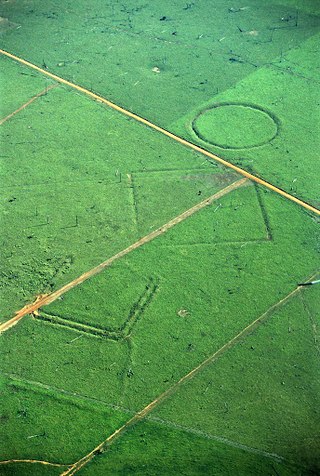
A geoglyph is a large design or motif produced on the ground by durable elements of the landscape, such as stones, stone fragments, gravel, or earth. A positive geoglyph is formed by the arrangement and alignment of materials on the ground in a manner akin to petroforms, while a negative geoglyph is formed by removing part of the natural ground surface to create differently coloured or textured ground in a manner akin to petroglyphs.
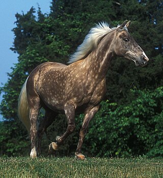
The Rocky Mountain Horse is a horse breed developed in the state of Kentucky in the United States. Despite its name, it originated not in the Rocky Mountains, but instead in the Appalachian Mountains. A foundation stallion, brought from the western United States to eastern Kentucky around 1890, began the Rocky Mountain type in the late 19th century. In the mid-20th century, a stallion named Old Tobe, owned by a prominent breeder, was used to develop the modern type; today most Rocky Mountain Horses trace back to this stallion. In 1986, the Rocky Mountain Horse Association was formed and by 2005 has registered over 12,000 horses. The breed is known for its preferred "chocolate" coat color and flaxen mane and tail, the result of the relatively rare silver dapple gene acting on a black coat, seen in much of the population. It also exhibits a four-beat ambling gait known as the "single-foot". Originally developed as a multi-purpose riding, driving and light draft horse, today it is used mainly for trail riding and working cattle.

Ute are the Indigenous people of the Ute tribe and culture among the Indigenous peoples of the Great Basin. They had lived in sovereignty in the regions of present-day Utah and Colorado in the Southwestern United States for many centuries until European settlers stole their lands. The state of Utah is named after the Ute tribe.
The Jackson Mountains are a north-northeast trending mountain range in southwestern Humboldt County, Nevada. The range is flanked on the west by the Black Rock Desert and the Black Rock Range beyond. To the north across the Quinn River and Nevada State Route 140 lie the Bilk Creek Mountains. To the northeast across Kings River Valley is the Double Mountains and to the east are the Sleeping Hills. To the southeast and south lie the Eugene and Kamma Mountains. The ghost town of Sulphur lies just southwest of the pass between the Jackson and Kamma ranges. Nevada State Route 49 and the Union Pacific railroad Feather River Route traverse this pass.

Minaret Summit is a mountain pass on Highway 203 in the central Sierra Nevada. The pass, lying on the Madera-Mono County border, is within the Mammoth Ranger District of the Inyo National Forest and located near Devils Postpile National Monument, Mammoth Lakes, and Mammoth Mountain. The elevation of the pass is about 9,265 ft (2,824 m). Highway 203 ends at Minaret Summit. The road continues, now called Reds Meadow Road, until its dead end at the Reds Meadow Pack Station near the Rainbow Falls trailhead.

The Crazy Horse Memorial is a mountain monument under construction on privately held land in the Black Hills, in Custer County, South Dakota, United States. It will depict the Oglala Lakota warrior Crazy Horse, riding a horse and pointing to his tribal land. The memorial was commissioned by Henry Standing Bear, a Lakota elder, to be sculpted by Korczak Ziolkowski. It is operated by the Crazy Horse Memorial Foundation, a nonprofit organization.

Devil's Den State Park is a 2,500-acre (1,000 ha) Arkansas state park in Washington County, near West Fork, Arkansas in the United States. The park was built by the Civilian Conservation Corps, beginning in 1933. Devil's Den State Park is in the Lee Creek Valley in the Boston Mountains, which are the southwestern part of The Ozarks. The park, with an 8 acres (3.2 ha) CCC-built lake, is open for year-round recreation, with trails for hiking, mountain biking and horseback riding. Devil's Den State Park also has several picnic areas, a swimming pool and cabins, with camping sites ranging from modern to primitive. Fossils of coral and crinoids can be found along the banks and within Lee Creek at Devil's Den State Park.

The Mountain states form one of the nine geographic divisions of the United States that are officially recognized by the United States Census Bureau. It is a subregion of the Western United States.
Horse Mountain is a prominent mountain summit in the San Juan Mountains range of the Rocky Mountains of North America. The 9,952-foot (3,033 m) peak is located in San Juan National Forest, 15.8 miles (25.5 km) west by north of the Town of Pagosa Springs in Archuleta County, Colorado, United States.

Echo Lake State Park is a public recreation area in North Conway, New Hampshire, that features 15.7-acre (6.4 ha) Echo Lake and two rock ledges with scenic views, Cathedral Ledge and White Horse Ledge. Activities include swimming, hiking, non-motorized boating, picnicking and fishing. There is a one-mile trail around the lake.
