White Plains, Virginia

Last updated

White Plains is an unincorporated community located in Brunswick County, in the U.S. state of Virginia.

Brunswick County, Virginia County in the United States

Brunswick County is a United States county located on the southern border of the Commonwealth of Virginia. This rural county is known as one the claimants to be the namesake of Brunswick stew.

U.S. state constituent political entity of the United States

In the United States, a state is a constituent political entity, of which there are currently 50. Bound together in a political union, each state holds governmental jurisdiction over a separate and defined geographic territory and shares its sovereignty with the federal government. Due to this shared sovereignty, Americans are citizens both of the federal republic and of the state in which they reside. State citizenship and residency are flexible, and no government approval is required to move between states, except for persons restricted by certain types of court orders. Four states use the term commonwealth rather than state in their full official names.

Virginia State of the United States of America

Virginia, officially the Commonwealth of Virginia, is a state in the Southeastern and Mid-Atlantic regions of the United States located between the Atlantic Coast and the Appalachian Mountains. Virginia is nicknamed the "Old Dominion" due to its status as the first English colonial possession established in mainland North America and "Mother of Presidents" because eight U.S. presidents were born there, more than any other state. The geography and climate of the Commonwealth are shaped by the Blue Ridge Mountains and the Chesapeake Bay, which provide habitat for much of its flora and fauna. The capital of the Commonwealth is Richmond; Virginia Beach is the most populous city, and Fairfax County is the most populous political subdivision. The Commonwealth's estimated population as of 2018 is over 8.5 million.

Brick House was listed on the National Register of Historic Places in 1982. [1]

Brick House (White Plains, Virginia) human settlement in Virginia, United States of America

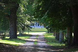
Brick House, also known as Woodlands, is a historic plantation house located at White Plains, Brunswick County, Virginia. It was built about 1831-1833, and began as a two-story, brick I-house. It was remodeled in 1860, with the addition of the massive hexastyle portico covering the entire front facade. Also on the property is a contributing 19th-century outbuilding connected to the main house by a covered walkway.

National Register of Historic Places federal list of historic sites in the United States

The National Register of Historic Places (NRHP) is the United States federal government's official list of districts, sites, buildings, structures, and objects deemed worthy of preservation for their historical significance. A property listed in the National Register, or located within a National Register Historic District, may qualify for tax incentives derived from the total value of expenses incurred preserving the property.

Related Research Articles

McKenney, Virginia Town in Virginia, United States

McKenney is an incorporated town in Dinwiddie County, Virginia, United States. The population was 483 at the 2010 census.

The Plains, Virginia Town in Virginia, United States

The Plains is a town in Fauquier County, Virginia, United States. The population was 217 at the 2010 census, down from 266 at the 2000 census. It is centered on the intersection of Virginia Route 55 and Virginia Route 245. The town of The Plains is situated off Interstate 66. The mayor of The Plains is Blake Gallagher.

Seven Pines place in Virginia listed on National Register of Historic Places

Seven Pines and the Seven Pines National Cemetery are located in the unincorporated town of Sandston in Henrico County, Virginia. Cemetery records state the name is derived from for a group of seven pine trees planted within the national cemetery in 1869 near the intersection of the old Williamsburg-Richmond Stage Road and the Nine Mile Road, however, the name "Seven Pines" pre-dates the establishment of the cemetery. Earlier maps and records, especially those from the American Civil War, commonly refer to the location as "Seven Pines." Today, the surrounding area is still referred to as "Seven Pines" although the local township is Sandston.

Margarettsville, North Carolina, USA, is an unincorporated community in northern Northampton County. The community is part of the Roanoke Rapids, North Carolina Micropolitan Statistical Area.

Drewryville, Virginia human settlement in Virginia, United States of America

Drewryville is an unincorporated community in western Southampton County, Virginia, United States, off U.S. Route 58. It lies at an elevation of 98 feet.

Hollister, North Carolina Census-designated place in North Carolina, United States

Hollister is a census-designated place and unincorporated community in Halifax County in northeastern North Carolina, United States. As of the 2010 census it had a population of 674. Hollister's ZIP code is 27844.

Brooke is an unincorporated community in Stafford County, Virginia, United States. It is the site of the Andrew Chapel United Methodist Church and Cemetery, and a Virginia Railway Express commuter rail station. Near the VRE station is the Stafford Civil War Park, that was established in April 2013. Along the shores of the Potomac Rivers' Aquia Creek is the Crow's Nest Natural Area Reserve and the Aquia Landing Park.

Uniontown, Maryland community in Carroll County, Maryland, United States

Uniontown is an unincorporated community in Carroll County, Maryland, United States. The community is home to the Uniontown Historic District, added to the National Register of Historic Places in 1986.

Blackwell is an unincorporated community in Washington County, in the U.S. state of Virginia.

Konnarock is an unincorporated community in Washington County, in the U.S. state of Virginia.

Oak Corner is an unincorporated community in Caroline County, in the U.S. state of Virginia.

Belspring, Virginia Census-designated place (CDP) in Virginia, United States

Belspring is a census-designated place (CDP) in Pulaski County, Virginia, United States, located at an elevation of 1,778 feet (542 m) above sea level. It has the ZIP Code 24058 and the area code 540. The population of the CDP was 256 at the 2010 Census.

Millboro is an unincorporated community in Bath County, Virginia, in the United States.

Meredithville is an unincorporated community located in Brunswick County, in the U.S. state of Virginia.

Valentines, Virginia unincorporated community in Brunswick County, Virginia

Valentines is an unincorporated community located in Brunswick County, in the U.S. state of Virginia.

Chula is an unincorporated community located in Amelia County, in the U.S. state of Virginia.

Fine Creek Mills is an unincorporated community in Powhatan County, in the U.S. state of Virginia.

Berry Hill is an unincorporated community in Pittsylvania County, in the U.S. state of Virginia. It is the site of an eponymous plantation Berry Hill that was added to the National Register of Historic Places in 1980.

Cascade is an unincorporated community in Pittsylvania County, in the U.S. state of Virginia.

Zanoni is an unincorporated community in Gloucester County, in the U. S. state of Virginia.

References

Coordinates: 36°38′40″N77°57′30″W / 36.64444°N 77.95833°W / 36.64444; -77.95833

Geographic coordinate system Coordinate system

A geographic coordinate system is a coordinate system that enables every location on Earth to be specified by a set of numbers, letters or symbols. The coordinates are often chosen such that one of the numbers represents a vertical position and two or three of the numbers represent a horizontal position; alternatively, a geographic position may be expressed in a combined three-dimensional Cartesian vector. A common choice of coordinates is latitude, longitude and elevation. To specify a location on a plane requires a map projection.