
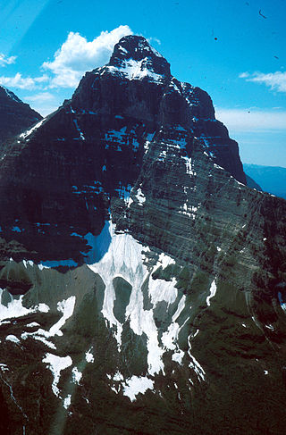
Mount Cleveland is the highest mountain in Glacier National Park, located in Montana, United States. It is also the highest point in the Lewis Range, which spans part of the northern portion of the park and extends into Canada. It is located approximately 3 mi (4.8 km) southeast of the southern end of Waterton Lake, and approximately 5 mi (8.0 km) south of the US–Canada border. The east side of the future national park was purchased by the federal government from the Blackfoot Confederacy in 1895 during the second term of President Grover Cleveland. According to the United States Board on Geographic Names, the mountain is named for the former president.

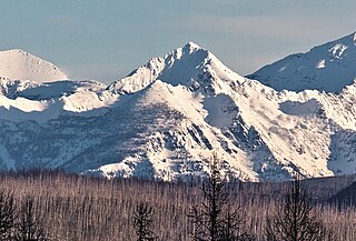
Heavens Peak is located in the Livingston Range, Glacier National Park in the U.S. state of Montana. Heavens Peak is a little more than 1 mile (1.6 km) north of McPartland Mountain. The mountain's descriptive name first appeared on a map prepared by Lt. George P. Ahern, from 1888 to 1890 reconnaissance maps prepared by him. This geographical feature's name was officially adopted in 1929 by the United States Board on Geographic Names.
The Lewis Range is a mountain range located in the Rocky Mountains of northern Montana, United States and extreme southern Alberta, Canada. It was formed as a result of the Lewis Overthrust, a geologic thrust fault resulted in the overlying of younger Cretaceous rocks by older Proterozoic rocks. The range is located within Waterton Lakes National Park in Alberta, Canada and Glacier National Park and the Bob Marshall Wilderness Complex in Montana, United States. The highest peak is Mount Cleveland at 10,479 ft (3,194 m).
Kinnerly Peak is located in the Livingston Range, Glacier National Park in the U.S. state of Montana. It is approximately 1 mile (1.6 km) north of Kintla Peak, the highest peak in the Livingston Range, and 3 miles (4.8 km) south of the Canada–United States border. Both peaks are in the remote northwest corner of the park. Kinnerly Peak is the eighth tallest peak in Glacier National Park.

Mount Jackson is located in the Lewis Range, Glacier National Park in the U.S. state of Montana. Mount Jackson is the fourth tallest mountain in Glacier National Park and it is situated on the Continental Divide. Both the mountain and its namesake Jackson Glacier are easily seen from the Going-to-the-Sun Road. Harrison Glacier, the park's largest remaining glacier, is located on the mountain's southern flank. Based on the Köppen climate classification, Mount Jackson has an alpine climate characterized by long, usually very cold winters, and short, cool to mild summers. Temperatures can drop below −10 °F with wind chill factors below −30 °F.

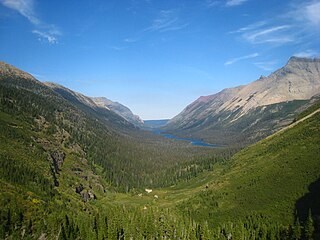
The following articles relate to the history, geography, geology, flora, fauna, structures and recreation in Glacier National Park (U.S.), the U.S. portion of the Waterton-Glacier International Peace Park.
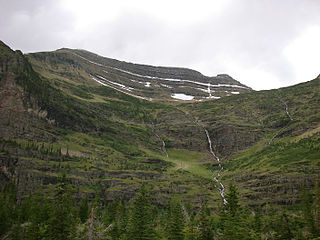
Crowfeet Mountain is located in the Lewis Range, Glacier National Park in the U.S. state of Montana. Crowfeet Mountain is situated on a ridgeline just south of the Ptarmigan Tunnel and is easily seen from Iceberg Lake to the southwest.

Kupunkamint Mountain is located in the Lewis Range, Glacier National Park in the U.S. state of Montana. Kupunkamint Mountain is in the southeastern section of Glacier National Park. The mountain's name was officially adopted in 1940 by the United States Board on Geographic Names to commemorate a Kootenai Indian.

Little Dog Mountain is located in the Lewis Range, Glacier National Park in the U.S. state of Montana. Little Dog Mountain sits along the Continental Divide and can be easily seen from Marias Pass. The mountain was named by George Bird Grinnell for "Little Dog," Blackfoot Indian Chief who, in 1853, informed Isaac Stevens, the new Governor of the Washington Territory, of the existence of Marias Pass.

Miche Wabun Peak is located in the Lewis Range, Glacier National Park in the U.S. state of Montana. Miche Wabun Peak is in the northeastern section of Glacier National Park and is north of Miche Wabun Lake.
Logging Mountain is located in the Livingston Range, Glacier National Park in the U.S. state of Montana. Logging Mountain rises more than 4,700 feet (1,400 m) above Logging Lake.

Longfellow Peak is located in the Livingston Range, Glacier National Park in the U.S. state of Montana. Longfellow Peak is immediately north of Paul Bunyans Cabin, a rock formation that resembles a log cabin from a distance. Lake Evangeline is northeast of the peak and Ruger Lake is to the east. The mountain was named by R. H. Sargent, topographer for the US Geological Survey in the early mapping of Glacier Park, to honor the American poet Henry Wadsworth Longfellow, (1807–1882).

Mount Oberlin is located in the Lewis Range, Glacier National Park in the U.S. state of Montana. Mount Oberlin is just northwest of Logan Pass. Below the summit to the northwest, water and melting snow off Mount Oberlin lead to the 492 feet (150 m) Bird Woman Falls, one of the tallest waterfalls in Glacier National Park.
Mount Peabody is located in the Livingston Range, Glacier National Park in the U.S. state of Montana. Agassiz Glacier is located on the western slopes of Mount Peabody.
Mount Pinchot is located in the Lewis Range, Glacier National Park in the U.S. state of Montana. Mount Pinchot is less than 1.5 miles (2.4 km) SSE of Mount Stimson while Beaver Woman Lake is southeast of Mount Pinchot.
Mount Thompson is located in the Lewis Range, Glacier National Park in the U.S. state of Montana.
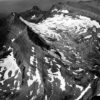
Whitecrow Glacier is in Glacier National Park, U.S. state of Montana. The glacier is situated immediately east of Mount Cleveland at an average elevation of 7,000 feet (2,100 m) above sea level. Whitecrow Glacier is in a cirque and consists of numerous ice patches, covering a combined surface area of 48 acres (0.19 km2). Between 1966 and 2005, Whitecrow Glacier lost over 47 percent of its surface area.
Whitecrow Lake is located in Glacier National Park, in the U. S. state of Montana. Whitecrow Lake is south of Whitecrow Mountain and east of Stoney Indian Peaks.
Glenns Lake is located in Glacier National Park, in the U. S. state of Montana. Glenns Lake is a long narrow lake located between Cosley Ridge and Whitecrow Mountain in the northeastern region of Glacier National Park. Mokowanis Lake is .50 miles (0.80 km) south of Glenns Lake.

Hidden Lake is located in Glacier National Park, in the U.S. state of Montana. The lake is surrounded by several peaks, including Bearhat Mountain to the southwest, Dragons Tail to the south, Clements Mountain to the north, and Reynolds Mountain to the east. It is a popular destination for hikers, with the Hidden Lake Overlook Trail leading to the lake.

