
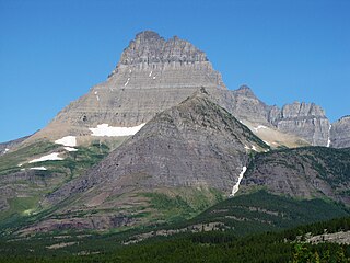
Mount Cleveland is the highest mountain in Glacier National Park, located in Montana, United States. It is also the highest point in the Lewis Range, which spans part of the northern portion of the park and extends into Canada. It is located approximately 3 mi (4.8 km) southeast of the southern end of Waterton Lake, and approximately 5 mi (8.0 km) south of the US–Canada border. The east side of the future national park was purchased by the federal government from the Blackfoot Confederacy in 1895 during the second term of President Grover Cleveland. According to the United States Board on Geographic Names, the mountain is named for the former president.
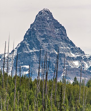
Mount Wilbur is located in the Lewis Range, Glacier National Park in the U.S. state of Montana. Plainly visible from the region of Many Glacier, the peak rises over 4,500 feet (1,372 m) above Swiftcurrent Lake and is a steep pyramid on three sides. The west slopes of the peak join to ridges along the continental divide. Much of the climbing routes are rated at class 4 to 5, with some only used once. The sedimentary rock of the mountains makes for often poor anchoring points and enhances the difficulty. A cirque on the north slopes of the mountain shelters Iceberg Lake, a popular hiking destination from Many Glacier. The mountain was named by George Bird Grinnell in 1885, for Edward R. Wilbur of New York, one of Grinnell's partners in the Forest and Stream Publishing Company, and both men were founders of the Audubon Society.

Chief Mountain is located in the U.S. state of Montana on the eastern border of Glacier National Park and the Blackfeet Indian Reservation. The mountain is one of the most prominent peaks and rock formations along the Rocky Mountain Front, a 200 miles (320 km) long overthrust fault, known as the Lewis Overthrust, which extends from central Montana into southern Alberta, Canada.

The Livingston Range is a mountain range located primarily in Glacier National Park in the U.S. state of Montana, and in the extreme southeastern section of the Canadian province of British Columbia. The range is 36 miles (58 km) long and 28 miles (45 km) wide. Over 15 summits exceed 9,000 ft (2,700 m) above sea level, and the highest point is Kintla Peak at 10,101 feet (3,079 m).
Mount Saint Nicholas is a peak in the remote southwestern section of Glacier National Park, in Montana. It is a particularly steep, pointed rock pinnacle, and its distinctive profile is visible from many summits in the southern half of the park. Because even its easiest ascent route is technical, with poor rock quality, it is "considered the most dangerous and difficult mountain for climbers in Glacier National Park."

Mount Gould is a peak on the Continental Divide in Glacier National Park, Montana, United States. It is the highest point of the Garden Wall, a distinctive ridge of the Lewis Range. It is most notable for its huge, steep east face, which drops 4,000 ft (1,220 m) in only one-half mile (0.8 km). This face provides a backdrop to Grinnell Lake, and is often photographed.

Bear Mountain is located in the northern Lewis Range, Glacier National Park in the U.S. state of Montana. Cosley Lake, followed by Glenns Lake to the southwest of the mountain. Mokowanis Lake is also visible from the peak. The mountain has tremendous views of the east face of Mount Cleveland, the north face of Mount Merritt, and the east face of Chief Mountain.

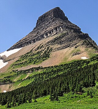
Iceberg Peak is located in the Lewis Range, Glacier National Park in the U.S. state of Montana. Iceberg Peak rises more than 3,000 feet (910 m) above Iceberg Lake and is considered a difficult climb due to the steepness and exposure climbers must endure. The peak sits astride the continental divide 1.1 mi (1.8 km) WNW of Mount Wilbur.

Ipasha Peak is located in the Lewis Range, Glacier National Park in the U.S. state of Montana. Ipasha Peak is 1.29 miles (2.08 km) south of Mount Merritt and is in the northeastern section of Glacier National Park. Ahern Glacier is located on the southeastern slopes of the mountain while the Ipasha Glacier is to the southwest of the peak. Helen Lake lies almost 4,500 feet (1,400 m) below the summit of Ipasha Peak to the southeast.

Kaina Mountain is located in the Lewis Range, Glacier National Park in the U.S. state of Montana. Kaina Mountain is in the northeastern section of Glacier National Park and north of Kaina Lake.

Mount Henkel is located in the Lewis Range, Glacier National Park in the U.S. state of Montana. Kennedy Lake is just to the north of the mountain.
Mount James is located in the Lewis Range, Glacier National Park in the U.S. state of Montana. Mount James is 1.35 miles (2.17 km) northeast of Triple Divide Peak. The Blackfeet name for the mountain is Ah'-kow-to-mak-an.

Mount Kipp is located in the Lewis Range, Glacier National Park in the U.S. state of Montana. Immediately east of the summit lies the retreating Chaney Glacier. Mount Kipp is situated along the Continental Divide. The mountain is presumed to have been named for Joe Kipp, a half-breed Indian trapper and scout who tried to prevent the Marias Massacre.

Mount Morgan is an 8,781-foot elevation (2,676 m) mountain located in the Lewis Range, Glacier National Park in the U.S. state of Montana. It is situated along the Continental Divide. Oldman Lake is immediately east of the peak.
Wahcheechee Mountain is located in the Lewis Range, Glacier National Park in the U.S. state of Montana. Stoney Indian Lake is just northeast of the peak.

Battlement Mountain is located in the Lewis Range, Glacier National Park in the U.S. state of Montana. Lake Isabel is northeast of the peak.

Olson Mountain, also known as Mount Olson, is a 7,913-foot-elevation mountain summit located in the Livingston Range, of Glacier National Park in the U.S. state of Montana. Olson Mountain rises more than 3,700 feet (1,100 m) above the western shore of Waterton Lake. The mountain was named for a surveyor on the International Boundary Survey, with the name officially adopted in 1929. The nearest higher peak is Campbell Mountain, 1.13 miles (1.82 km) to the north, and Citadel Peaks is two miles (3.2 km) to the south. Precipitation runoff from the mountain drains into Olson Creek before it empties to Waterton Lake.

Citadel Peaks is a mountain ridge located in the Goat Haunt area of Glacier National Park, in Glacier County of the U.S. state of Montana. This arête with a row of sharp points is part of the Livingston Range, and is approximately four miles east of the Continental Divide. Neighbors include Olson Mountain, two miles (3.2 km) to the north, Mount Cleveland four miles (6.4 km) to the east, and Kootenai Peak 2.7 miles (4.3 km) to the south. Topographic relief is significant as Citadel Peaks rises over 3,800 feet above Waterton Lake in less than two miles, and 3,000 feet above Lake Janet in one mile. Precipitation runoff from the mountain drains to the south end of Waterton Lake. The first ascent of Citadel Spire, a major pinnacle on the ridge, was made in 1967 by Jerry Kanzler, Jim Kanzler, Ray Martin, and Clare Pogreba. This geographical feature's name was officially adopted in 1929 by the United States Board on Geographic Names. To the Pikuni people, Citadel Peaks is known as "Ataniawxis", meaning "The Needles".

Porcupine Ridge is a prominent mountain ridge located in the Goat Haunt area of Glacier National Park, in Glacier County of the U.S. state of Montana. This mountain is part of the Livingston Range, and is situated 1.5 mile east of the Continental Divide. Topographic relief is significant as the summit rises approximately 3,900 feet above Lake Frances in one mile, and nearly 5,000 feet above Waterton Lake in five miles. Precipitation runoff from the mountain drains to the Waterton River via Olson and Valentine Creeks. This geographical feature's name was officially adopted in 1911 by the United States Board on Geographic Names.

Crypt Peak is an 8,579-foot (2,615 m) mountain summit located in Glacier National Park, in Glacier County of the U.S. state of Montana. It is situated along the Canada–United States border, above Crypt Lake, and is partially within Waterton Lakes National Park. Crypt Peak is part of the Lewis Range, and is approximately three miles east of Waterton Lake. Topographic relief is significant as Crypt Peak rises over 2,100 feet above Crypt Lake in approximately one-half mile (1.6 km), and 4,400 ft (1,340 m) above Waterton Lake in three miles (4.8 km). Precipitation runoff from the mountain drains west to Waterton Lake, and east to Belly River. This geographical feature's name has not yet been officially adopted by the United States Board on Geographic Names.


