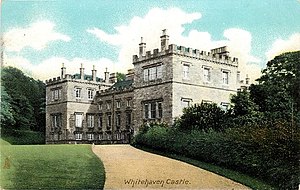
Whitehaven Castle is a historic building in Whitehaven, Cumbria. It is a Grade II listed building. [1]
Whitehaven Castle is a historic building in Whitehaven, Cumbria. It is a Grade II listed building. [1]
The building was constructed for Sir John Lowther as his private residence; it was originally known as Flatt Hall and was completed in 1769. [1] In 1924, the Earl of Lonsdale sold Whitehaven Castle to Herbert Wilson Walker, a local industrialist, who then donated the building to the people of West Cumberland, along with £20,000 to convert it into a new hospital. [2] Later, a second new hospital, the West Cumberland Hospital was opened in 1964 by the Queen Mother, and Whitehaven Castle then became a facility for the elderly and has since been converted into apartments. [1]
Cumberland is one of the historic counties of England.

Westmorland is a historic county in North West England. It formed an administrative county between 1889 and 1974, after which the whole county was administered by the new administrative and ceremonial county of Cumbria. The people of Westmorland are known as Westmerians. In April 2023, it is planned that local government in Cumbria will be reorganised into two unitary authorities, one of which is to be named Westmorland and Furness and would cover all of the historic county along with parts of historic Yorkshire, Lancashire and Cumberland.

Cumberland is a historic county in North West England that had an administrative function from the 12th century until 1974. It is bordered by the historic counties of Northumberland to the north-east, County Durham to the east, Westmorland to the south-east, Lancashire to the south, and the Scottish counties of Dumfriesshire and Roxburghshire to the north. It formed an administrative county from 1889 to 1974 and now forms part of Cumbria. In April 2023, local government in Cumbria will be reorganised into two unitary authorities; one of these is to be named Cumberland and would include most of the historic county, with the exception of Penrith and the surrounding area.

Millom is a town and civil parish on the north shore of the estuary of the River Duddon in southwest Cumbria, historically part of Cumberland, England. It is situated just outside the Lake District National Park, about six miles north of Barrow-in-Furness and 26 mi (42 km) south of Whitehaven.

Whitehaven is a town and port on the English north west coast and near to the Lake District National Park in Cumbria, England. Historically in Cumberland, it lies by road 38 miles (61 km) south-west of Carlisle and 45 miles (72 km) to the north of Barrow-in-Furness. It is the administrative seat of the Borough of Copeland, and has a town council for the parish of Whitehaven. The population of the town was 23,986 at the 2011 census.

The A595 is a primary route in Cumbria, in Northern England that starts in Carlisle, passes through Whitehaven and goes close to Workington, Cockermouth and Wigton. It passes Sellafield and Ravenglass before ending at the Dalton-in-Furness by-pass, in southern Cumbria, where it joins the A590 trunk road. The road is mostly single carriageway, apart from in central Carlisle, where it passes the castle as a busy dual carriageway road named Castle Way, and prior to that as Bridge Street and Church Street, where it passes close to the McVitie's or Carr's biscuit factory. The Lillyhall bypass is also dual carriageway.

Egremont is a market town, civil parish and two electoral wards in Cumbria, England, and historically part of Cumberland. It is situated just outside the Lake District National Park, five miles south of Whitehaven and on the River Ehen.

Penrith Castle is a now-ruined medieval castle located in Penrith, in the north-west of England, a few miles to the east of the Lake District National Park.

Muncaster Castle is a privately owned castle overlooking the River Esk, about a mile east of the west-coastal town of Ravenglass in Cumbria, England. It is recorded in the National Heritage List for England as a designated Grade I listed building.

Appleby Castle is in the town of Appleby-in-Westmorland overlooking the River Eden. It consists of a 12th-century castle keep which is known as Caesar's Tower, and a mansion house. These, together with their associated buildings, are set in a courtyard surrounded by curtain walls. Caesar's Tower and the mansion house are each recorded in the National Heritage List for England as a designated Grade I listed building. The uninhabited parts of the castle are a scheduled ancient monument.

St Bees Priory is the parish church of St Bees, Cumbria, England. There is evidence for a pre-Norman religious site, and on this a Benedictine priory was founded by the first Norman Lord of Egremont William Meschin, and was dedicated by Archbishop Thurstan of York, sometime between 1120 and 1135.

Appleby Grammar School is a mixed secondary school and sixth form in Appleby-in-Westmorland, Cumbria for students aged 11 to 18. Since 2011, it has been an Academy. Until 2013, the school was a registered charity.

West Cumberland Hospital is a hospital in Hensingham, a suburb of Whitehaven in Cumbria, England, and was the first district general hospital to be built in England following the creation of the National Health Service. It is managed by the North Cumbria Integrated Care NHS Foundation Trust. A campaign group is fighting to maintain hospital services at the West Cumberland Hospital, many of which have been moved to the Cumberland Infirmary, 40 mi (64 km) away from the population centres of the West Cumbrian coast.
Waitby is a small village and civil parish in the Eden district of Cumbria, England. The parish contains two small villages, Waitby and Smardale, plus the small hamlets of Riddlesay, Stripes and Leases, all of which are in the farmed and enclosured northern part at an elevation of around 200–300m. The southern half of the parish is mostly heath and unused for agriculture, it rises to Smardale fell; which it includes, at elevations between 300 and 400m. The civil parish of Ravenstonedale forms the boundary to the south. The western border with Crosby Garrett civil parish is formed by Scandal Beck. To the north and east lie Soulby and Kirkby Stephen civil parishes respectively. The population of the civil parish as measured at the 2011 Census was less than 100. Details are included in the parish of Crosby Garrett.

St Michael's Chapel is the former Anglican chapel to Lancaster Moor Hospital, to the east of Lancaster, Lancashire, England. It was built in 1866 to a design by the local architect E. G. Paley. Its architectural style is Neo-Norman. The chapel is constructed in sandstone with ashlar dressings and a slate roof. Its plan is cruciform, consisting of a nave with a west porch, north and south transepts, and a chancel with an apsidal east end. The windows are round-headed with voussoirs of alternating red and yellow sandstone. Both transepts contain a rose window above two single-light windows. Since becoming redundant the chapel has been converted into flats. The former chapel is recorded in the National Heritage List for England as a designated Grade II listed building.

St James' Church is in High Street, Whitehaven, Cumbria, England, at the crossing with the top of Queen Street. It stands in an elevated position overlooking the town. The church is an active Anglican parish church in the deanery of Calder, the archdeaconry of West Cumberland, and the diocese of Carlisle. The church is recorded in the National Heritage List for England as a designated Grade I listed building.

Millom Castle is an ancient building at Millom in Cumbria. It is a Grade I listed building and scheduled ancient monument.

Overwater Hall is a country house near Ireby in Cumbria. It is a Grade II Listed building.
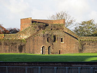
Carlisle city walls were a defensive structure surrounding the centre of Carlisle, Cumbria. The city walls ran from Carlisle Castle in the north-west of the city to The Citadel in the south-east. Between these points, the city was protected by the former North and East Walls and the West Walls which remain largely intact. The line of the walls can still be followed with the exception of the southernmost end of the West Wall which has been built over. The perimeter, including the castle, is approximately 2.2 kilometres (1.4 mi) which is comparable to Southampton town walls but less than Chester city walls.
Whitehaven is a town and civil parish in the Borough of Copeland, Cumbria, England. It contains over 170 buildings that are recorded in the National Heritage List for England. Of these, one is listed at Grade I, the highest of the three grades, six are at Grade II*, the middle grade, and the others are at Grade II, the lowest grade.