
Gloucestershire is a county in South West England. The county comprises part of the Cotswold Hills, part of the flat fertile valley of the River Severn and the entire Forest of Dean.

Thornbury is a market town and civil parish in the South Gloucestershire unitary authority area of England, about 12 mi (19 km) north of Bristol. It had a population of 12,063 at the 2011 census. The population has risen to 14,496 in the 2021 census. Thornbury is a Britain in Bloom award-winning town, with its own competition: Thornbury in Bloom. The earliest documentary evidence of a village at "Thornbyrig" dates from the end of the 9th century. Domesday Book noted a manor of "Turneberie" belonging to William the Conqueror's consort, Matilda of Flanders, with 104 residents.

Stroud is a market town and civil parish in Gloucestershire, England. It is the main town in Stroud District. The town's population was 13,500 in 2021.

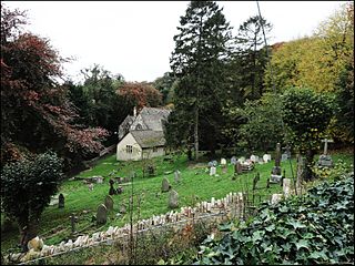
Painswick is a town and civil parish in the Stroud District in Gloucestershire, England. Originally the town grew from the wool trade, but it is now best known for its parish church's yew trees and the local Rococo Garden. The village is mainly constructed of locally quarried Cotswold stone. Many of the buildings feature south-facing attic rooms once used as weavers' workshops.

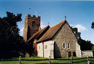
Filton is a town and civil parish in South Gloucestershire, England, 5.5 miles (9 km) north of Bristol. Along with nearby Patchway and Bradley Stoke, Filton forms part of the Bristol urban area and has become an overflow settlement for the city. Filton Church dates back to the 12th century and is designated a Grade II listed building.
Blockley is a village, civil parish and ecclesiastical parish in the Cotswold district of Gloucestershire, England, about 3 miles (5 km) northwest of Moreton-in-Marsh. Until 1931 Blockley was an exclave of Worcestershire.

Coalpit Heath is a small village in the parish of Westerleigh, South Gloucestershire, England, south of Yate and east of Frampton Cotterell in South Gloucestershire.

Barnwood is an eastern suburb of Gloucester, lying about 1.8 miles (2.9 km) from the centre of the city, and former civil parish, now in the unparished area of Gloucester, in the Gloucester district, in the county of Gloucestershire, England.
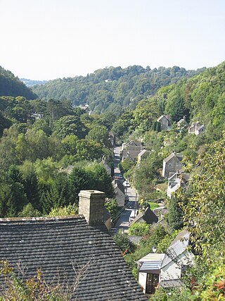
Chalford is a large village in the Frome Valley of the Cotswolds in Gloucestershire, England. It is to the southeast of Stroud about four miles upstream. It gives its name to Chalford parish, which covers the villages of Chalford, Chalford Hill, France Lynch, Bussage and Brownshill, spread over two square miles of the Cotswold countryside. At this point the valley is also called the Golden Valley.

Andoversford is a village and civil parish in the Cotswold District of Gloucestershire, England, about 5 miles (8 km) east of Cheltenham. The village is on the River Coln, parallel to the A40.The 2011 Census recorded the parish's population as 555. In 2019 the parish a population of 905.

Arlingham is a village and civil parish in the Stroud District of Gloucestershire, England. The 2001 Census recorded a parish population of 410, increasing to 459 at the 2011 census. The parish contains the hamlets of Milton End, Overton and Priding. The next parish to the east is Fretherne with Saul.

Broadwell is a village and civil parish in the English county of Gloucestershire. It is about 1.5 miles (2.4 km) north of Stow-on-the-Wold, In the 2001 United Kingdom census, the parish had a population of 384. decreasing to 355 at the 2011 census.

Brookthorpe-with-Whaddon, formerly just Brookthorpe is a civil parish in the Stroud district of Gloucestershire, England. According to the 2001 census it had a population of 308, increasing to 322 at the 2011 census. In 2019 the population was estimated at 395. It consists of the small villages of Brookthorpe and Whaddon, both to the south of Gloucester.
Rodborough is a large village and civil parish in the district of Stroud, Gloucestershire, in South West England. It is directly south of the town of Stroud, north of the town of Nailsworth and north-west of the town of Minchinhampton. The parish includes the settlements of Bagpath, Butterrow, Kingscourt, Lightpill and Rooksmoor, and is adjacent to the Stroud suburb of Dudbridge. The population taken at the 2011 census was 5,334.

Nympsfield is a village and civil parish in the English county of Gloucestershire. It is located around four miles south-west of the town of Stroud. As well as Nympsfield village, the parish contains the hamlet of Cockadilly. The population taken at the 2011 census was 382.
Ruscombe is a village and civil parish, east of Twyford in the Borough of Wokingham in Berkshire, England.

Edgeworth is a small village and civil parish in the English county of Gloucestershire. It is located east of Stroud, west of Cirencester and south of Cheltenham.
Randwick is a village bordering the market town of Stroud in Gloucestershire, England, the United Kingdom. It is known locally for its folk traditions such as the Randwick Wap, a celebration of May Day, and its annual pantomime.

Edge is a village in the civil parish of Painswick, Gloucestershire, England. The village is situated in an area of the Cotswolds that falls within the Stroud District.

Pitchcombe is a village and civil parish 6 miles (9.7 km) south of Gloucester, in the Stroud district, in the county of Gloucestershire, England. In 2011 the parish had a population of 232. The parish touches Harescombe, Painswick and Whiteshill and Ruscombe.

