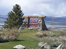
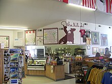
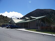
The Whoa Nellie Deli is a casual gourmet restaurant located in Lee Vining, California, east of Yosemite National Park and just west of Mono Lake. The restaurant has received coverage from newspapers and magazines across the United States.


The Whoa Nellie Deli is a casual gourmet restaurant located in Lee Vining, California, east of Yosemite National Park and just west of Mono Lake. The restaurant has received coverage from newspapers and magazines across the United States.
The Whoa Nellie Deli is located in a Mobil gas station named the Tioga Gas Mart on a hilltop just southwest of the intersection of U.S. Route 395 and California State Route 120, one mile south of the business district of the small town of Lee Vining, California. The business was founded in 1996. [1] Geographically, this location is where the eastern edge of the Sierra Nevada meets the western edge of the Great Basin. Mount Dana and other High Sierra peaks are visible to the west. The eastern entrance of Yosemite National Park, located at Tioga Pass, is 12 miles to the west. Mono Lake, a uniquely salty and mineral saturated body of water, is visible from the restaurant to the northeast. The gas station also offers a gift shop, a small grocery store, and picnic facilities. Live musical performances are featured about 30 times each year from late spring to early autumn, usually on Thursday and Sunday evenings. The restaurant is closed in the winter. Trapeze lessons were once offered, but liability insurance considerations led to the cancellation of this service.
The restaurant's location was described by the San Francisco Chronicle as "a misplaced Fellini set carved into the edge of the Mono Basin, dust devils skipping around in the distance like extras on the floor of Owens Valley." [2]
In an article about visiting Mono Lake, The New York Times commented, "When the desire that is the cause of all human suffering returned in the form of appetite, our editors were relieved to find the Whoa Nellie Deli, a shockingly gourmet oasis located at the local Tioga Gas Mart." [3]
In 2022, owners Dennis Domaille and his daughter, Denise Molnar announced their intention to sell the 70 acre property including the gas station, store and restaurant for $16.5 million. [1]
Gourmet magazine observed, "For all its awesome scenery, the Yosemite Valley used to be a culinary wasteland. Now, hikers can hoof it to the national park's eastern entrance for lobster taquitos and pan-seared ahi salad served up at Whoa Nellie Deli, inside the Mobil gas station on Highway 120. Beyond the pumps, Matt Toomey turns out house specials like fish tacos with ginger coleslaw and wasabi crème fraiche, seafood stew with mashed potatoes and garlic bread and even mango Margaritas." [4] The restaurant is located 75 miles away from Yosemite Valley, and it takes well over two hours to drive there.
Lisa Margonelli, an Irvine Fellow at New America Foundation observed in the pages of The Atlantic that the "deli" is actually a "nuttily gourmet kitchen that turns out huge platefuls of food," and that "the deli is a continuous party all summer long." [5]
The San Marcos Daily Record of Texas said that Whoa Nellie Deli is an "exceptional eatery" that "offers unexpected surprises with great selections of fine foods." [6]
The Los Angeles Times described chef Matt Toomey as "a manic figure in a white chef's jacket and a baseball cap" whose "charisma and sense of humor are reflected in his cooking." The apricot and wild berry glazed pork loin and the top sirloin steak with a dozen grilled shrimp were described as "beautifully presented and cooked to perfection." The dining experience was summarized this way: "To have one of the better meals of your life in a gas station is bizarre. It leaves you staring at your plate for a moment or two in disbelief." [7]
Commenting on the incongruity between the quality of the food and the fact that gasoline is pumped at the same business, the San Diego Union-Tribune asked, "But who would have believed slices of perfectly seasoned and seared sashimi-grade ahi, fanned on a bed of edible seaweed, served in a gas station?" [8]

Mono Lake is a saline soda lake in Mono County, California, formed at least 760,000 years ago as a terminal lake in an endorheic basin. The lack of an outlet causes high levels of salts to accumulate in the lake which make its water alkaline.

The exposed geology of the Yosemite area includes primarily granitic rocks with some older metamorphic rock. The first rocks were laid down in Precambrian times, when the area around Yosemite National Park was on the edge of a very young North American continent. The sediment that formed the area first settled in the waters of a shallow sea, and compressive forces from a subduction zone in the mid-Paleozoic fused the seabed rocks and sediments, appending them to the continent. Heat generated from the subduction created island arcs of volcanoes that were also thrust into the area of the park. In time, the igneous and sedimentary rocks of the area were later heavily metamorphosed.

Mammoth Mountain Ski Area is a large ski resort in the western United States, located in eastern California along the east side of the Sierra Nevada mountain range in the Inyo National Forest.

Tioga Pass is a mountain pass in the Sierra Nevada mountain range of California. State Route 120 runs through it, and serves as the eastern entry point for Yosemite National Park, at the Tioga Pass Entrance Station. It is the highest elevation highway pass in California and in the Sierra Nevada at an elevation of 9,945 ft (3,031 m). Mount Dana is to the east of the pass, and Gaylor Peak to the west.

State Route 120 is a state highway in the central part of California, connecting the San Joaquin Valley with the Sierra Nevada, Yosemite National Park, and the Mono Lake area. Its western terminus is at Interstate 5 in Lathrop, and its eastern terminus is at U.S. Route 6 in Benton. While the route is signed as a contiguous route through Yosemite, the portion inside the park is federally maintained and is not included in the state route logs. The portion at Tioga Pass at Yosemite's eastern boundary is the highest paved through road in the California State Route system. This part is not maintained in the winter and is usually closed during the winter season.

Lee Vining is an unincorporated community and census-designated place (CDP) in Mono County, California, United States. It is located 25 miles (40 km) south-southeast of Bridgeport, at an elevation of 6,781 feet (2,067 m). Lee Vining is located on the southwest shore of Mono Lake. The population was 217 as of the 2020 census.

Tenaya Lake is an alpine lake in Yosemite National Park, located between Yosemite Valley and Tuolumne Meadows. The surface of Tenaya Lake has an elevation of 8,150 feet (2,484 m). The lake basin was formed by glacial action, which left a backdrop of light granite rocks, whose beauty was known to the Native Americans. Today, Tenaya Lake is easily accessible by State Route 120 and is a popular lake for water activities.

Virginia Lakes refers to a basin of lakes in the Eastern Sierra Nevada in Mono County, California. Virginia Lakes is located a few miles off U.S. Highway 395; the road to the lakes turns off U.S. 395 at Conway Summit, roughly halfway between Bridgeport, California, to the north and Lee Vining, California, to the south, in the Humboldt-Toiyabe National Forest. The name can also refer to two lakes within the basin: Little or Lower Virginia Lake and Upper or Big Virginia Lake. The area is part of the Virginia Lakes census-designated place.

Inyo National Forest is a United States National Forest covering parts of the eastern Sierra Nevada of California and the White Mountains of California and Nevada. The forest hosts several superlatives, including Mount Whitney, the highest point in the contiguous United States; Boundary Peak, the highest point in Nevada; and the Ancient Bristlecone Pine Forest, which protects the oldest living trees in the world. The forest, encompassing much of the Owens Valley, was established by Theodore Roosevelt as a way of sectioning off land to accommodate the Los Angeles Aqueduct project in 1907, making the Inyo National Forest one of the least wooded forests in the U.S. National Forest system.

The Mono Basin is an endorheic drainage basin located east of Yosemite National Park in California and Nevada. It is bordered to the west by the Sierra Nevada, to the east by the Cowtrack Mountains, to the north by the Bodie Hills, and to the south by the north ridge of the Long Valley Caldera.

The Save Mart Companies is an American grocery store operator founded and headquartered in Modesto, California. It owns and operates stores under the Save Mart, Lucky, and FoodMaxx brands. The stores are located in northern and central California and northern Nevada. The company is owned by the Jim Pattison Group.

June Lake is an unincorporated community and census-designated place (CDP) in Mono County, California, United States. It is located against the southern rim of the Mono Basin, 12.5 miles (20 km) south of Lee Vining, at an elevation of 7,654 feet (2,333 m).

The Mono Basin National Forest Scenic Area is a protected area in Eastern California that surrounds Mono Lake and the northern half of the Mono Craters volcanic field. It is administered by the Inyo National Forest as a unit of the National Forest Scenic Area program, under the U.S. Forest Service.
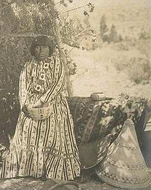
The Kucadɨkadɨ are a band of Eastern Mono Northern Paiute people who live near Mono Lake in Mono County, California. They are the southernmost band of Northern Paiute.

Lee Vining Creek is a 16.2-mile-long (26.1 km) stream in Mono County, California, flowing into the endorheic basin of Mono Lake. It is the second largest stream flowing into the lake, after Rush Creek.
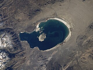
Lake Russell is a former lake stage of Mono Lake. It was named in honour of Israel Russell, but is also known as Lake Mono in contrast to the present-day lake. This lake was larger than present-day Mono Lake and occasionally overflowed first into the East Walker River and later into the Owens River. During its existence, glaciers from the Sierra Nevada reached to its shore.
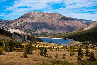
Tioga Peak is located in Mono County, California, approximately two miles outside of Yosemite National Park. It is situated in the Hoover Wilderness on land managed by Inyo National Forest.

Gaylor Peak is an 11,004-foot-elevation (3,354 meter) mountain summit located on the crest of the Sierra Nevada mountain range in northern California, United States. The peak is situated on the common boundary shared by Yosemite National Park with Inyo National Forest, as well as the border shared by Mono County with Tuolumne County. It rises immediately above the park's Tioga Pass entrance station and Tioga Lake. Topographic relief is significant as the summit rises approximately 1,400 feet above the lake in one-half mile (0.80 km). The peak is a popular hiking destination on summer weekends due to easy access via the two-mile Gaylor Lakes Trail from State Route 120 which traverses the east base of the peak.