
New Britain is the largest island in the Bismarck Archipelago, part of the Islands Region of Papua New Guinea. It is separated from New Guinea by a northwest corner of the Solomon Sea and from New Ireland by St. George's Channel. The main towns of New Britain are Rabaul/Kokopo and Kimbe. The island is roughly the size of Taiwan. While the island was part of German New Guinea, it was named Neupommern . In common with most of the Bismarcks it was largely formed by volcanic processes, and has active volcanoes including Ulawun, Langila, the Garbuna Group, the Sulu Range, and the volcanoes Tavurvur and Vulcan of the Rabaul caldera. A major eruption of Tavurvur in 1994 destroyed the East New Britain provincial capital of Rabaul. Most of the town still lies under metres of ash, and the capital has been moved to nearby Kokopo.

USS Amberjack (SS-219) was a Gato-class submarine, the first United States Navy ship named for the amberjack.

The Battle of Rabaul, also known by the Japanese as Operation R, an instigating action of the New Guinea campaign, was fought on the island of New Britain in the Australian Territory of New Guinea, from 23 January into February 1942. It was a strategically significant defeat of Allied forces by Japan in the Pacific campaign of World War II, with the Japanese invasion force quickly overwhelming the small Australian garrison, the majority of which was either killed or captured. Hostilities on the neighbouring island of New Ireland are usually considered to be part of the same battle. Rabaul was significant because of its proximity to the Japanese territory of the Caroline Islands, site of a major Imperial Japanese Navy base on Truk.

The Bougainville campaign was a series of land and naval battles of the Pacific campaign of World War II between Allied forces and the Empire of Japan, named after the island of Bougainville. It was part of Operation Cartwheel, the Allied grand strategy in the South Pacific. The campaign took place in the Northern Solomons in two phases. The first phase, in which American troops landed and held the perimeter around the beachhead at Torokina, lasted from November 1943 through November 1944.

Operation Chronicle was the Allied invasion of Woodlark and Kiriwina Islands, in the South West Pacific, during World War II. The operation was a subordinate action that formed part of the wider Operation Cartwheel, the advance towards Rabaul. An early planning name for this operation was Operation Coronet. Preliminary actions commenced on 23–24 June 1943 when small reconnaissance parties were landed on both islands. The main operation was executed without opposition on 30 June 1943. Around 16,800 personnel took part, divided into two forces. The United States Army provided the majority of ground troops, which were supported by a United States Marine Corps defense battalion as well as U.S. and Australian aircraft and naval vessels.

The Solomon Islands campaign was a major campaign of the Pacific War of World War II. The campaign began with Japanese landings and occupation of several areas in the British Solomon Islands and Bougainville, in the Territory of New Guinea, during the first six months of 1942. The Japanese occupied these locations and began the construction of several naval and air bases with the goals of protecting the flank of the Japanese offensive in New Guinea, establishing a security barrier for the major Japanese base at Rabaul on New Britain, and providing bases for interdicting supply lines between the Allied powers of the United States and Australia and New Zealand.

The New Guinea campaign of the Pacific War lasted from January 1942 until the end of the war in August 1945. During the initial phase in early 1942, the Empire of Japan invaded the Australian-administered Mandated Territory of New Guinea and the Australian Territory of Papua and overran western New Guinea, which was a part of the Netherlands East Indies. During the second phase, lasting from late 1942 until the Japanese surrender, the Allies—consisting primarily of Australian forces—cleared the Japanese first from Papua, then the Mandate and finally from the Dutch colony.
The New Britain campaign was a World War II campaign fought between Allied and Imperial Japanese forces. The campaign was initiated by the Allies in late 1943 as part of a major offensive which aimed to neutralise the important Japanese base at Rabaul, the capital of New Britain, and was conducted in two phases between December 1943 and the end of the war in August 1945.
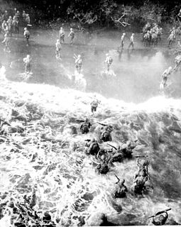
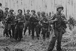
The Battle of Cape Gloucester was fought in the Pacific theater of World War II between Japanese and Allied forces on the island of New Britain, Territory of New Guinea, between 26 December 1943 and 16 January 1944. Codenamed Operation Backhander, the US landing formed part of the wider Operation Cartwheel, the main Allied strategy in the South West Pacific Area and Pacific Ocean Areas during 1943–1944. It was the second landing the US 1st Marine Division had conducted during the war thus far, after Guadalcanal. The objective of the operation was to capture the two Japanese airfields near Cape Gloucester that were defended by elements of the Japanese 17th Division.
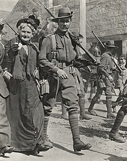
The Battle of Bita Paka was fought south of Kabakaul, on the island of New Britain, and was a part of the invasion and subsequent occupation of German New Guinea by the Australian Naval and Military Expeditionary Force (AN&MEF) shortly after the outbreak of the First World War. Similar to New Zealand's operation against German Samoa in August, the main target of the operation was a strategically important wireless station—one of several used by the German East Asiatic Squadron—which the Australians believed to be located in the area. The powerful German naval fleet threatened British interests and its elimination was an early priority of the British and Australian governments during the war.

Operation RY was the Imperial Japanese plan to invade and occupy Nauru and Ocean islands in the south Pacific during the Pacific conflict of World War II. The operation was originally set to be executed in May 1942 immediately following Operation MO and before Operation MI, which resulted in the Battle of Midway. The primary reason for the operation was to exploit the islands' supplies of phosphate. After a postponement due to interference by enemy forces, the operation was completed in August 1942.
Ro-34 was a Kaichū type submarine of the K5 sub-class built for the Imperial Japanese Navy. Completed and commissioned in May 1937, she served in World War II, operating in the South China Sea and the Netherlands East Indies, off New Guinea, and in the Solomon Islands. She was sunk in April 1943 during her eleventh war patrol.
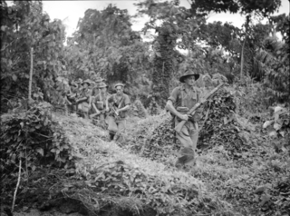
The Battle of Wide Bay–Open Bay was a battle during the New Britain campaign of the Second World War. Following the arrival of the Australians on New Britain in late 1944, replacing the US garrison on the island, they began a limited offensive against the Japanese forces on the island. Pushing east from the positions previously captured by the US troops earlier in the year, after landing at Jacquinot Bay on the southern coast in November, the Australians began advancing across the island towards the Gazelle Peninsula, where they sought to isolate the numerically superior Japanese garrison. This advance was effected along two axes: Cape Hoskins to Open Bay on the northern coast, and Jacquinot Bay to Wide Bay on the southern. Once the Australians had secured a line across the island between Wide Bay and Open Bay in March and April 1945, the fighting on New Britain died down as the Australians sought to contain the larger Japanese garrison while limiting their own casualties. This situation lasted until the end of the war in August 1945.

The Landing at Jacquinot Bay was an Allied amphibious operation undertaken on 4 November 1944 during the New Britain Campaign of World War II. The landing was conducted as part of a change in responsibility for Allied operations on New Britain. The Australian 5th Division, under Major General Alan Ramsay, took over from the US 40th Infantry Division, which was needed for operations in the Philippines. The purpose of the operation was to establish a logistics base at Jacquinot Bay on the south coast of New Britain to support the 5th Division's planned operations near the major Japanese garrison at Rabaul.
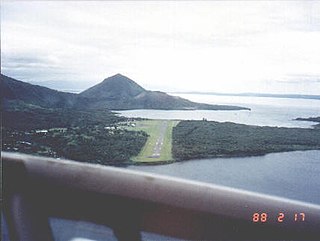
Lakunai Airfield, later known as Rabaul Airport; was an aerodrome located near Rabaul, East New Britain, Papua New Guinea. It was located at the foot of Tavurvur volcano, near Matupit Island. The airport was destroyed by the 1994 eruption that destroyed the town of Rabaul and subsequently a new airport was built and opened at Tokua, on the opposite side of the Rabaul caldera. The former airport was located at 04°13′S152°11′E.

Kerevat Airfield was an aerodrome located near Kerevat, East New Britain province, Papua New Guinea. Situated on the northern coast, it was 13 miles (21 km) south west of Rabaul. The airfield was constructed by the Imperial Japanese in World War II during September 1943. Kerevat Airfield was neutralized by Allied Powers' air bombing from 1944, who ran missions on the airfield between June 20, 1943, and May 16, 1944. The airfield was abandoned after the cessation of hostilities; however, the airstrip is still visible.

The 8th Military District was an administrative district of the Australian Army. During the Second World War, the 8th Military District covered the Territory of New Guinea, the Solomon Islands and the New Hebrides, with its headquarters firstly at Rabaul and later at Port Moresby.

The Battle of Talasea was a battle fought in the Pacific theater of World War II between Japanese and Allied forces. Dubbed "Operation Appease" by the Allies, the battle was part of the wider Operations Dexterity and Cartwheel, and took place on the island of New Britain, Territory of New Guinea, in March 1944 as primarily US forces, with limited Australian support, carried out an amphibious landing to capture the Talasea area of the Willaumez Peninsula, as part of follow up operations as the Japanese began withdrawing east towards Rabaul following heavy fighting around Cape Gloucester earlier in the year. The assault force consisted of a regimental combat team formed around the 5th Marines, which landed on the western coast of the Willaumez Peninsula, on the western side of a narrow isthmus near the Volupai Plantation. Following the initial landing, the Marines advanced east towards the emergency landing strip at Talasea on the opposite coast. Their advance south was stymied by a small group of Japanese defenders who prevented the US troops from advancing quickly enough to cut off the withdrawal of the Japanese force falling back from Cape Gloucester.
Open Bay is a bay located to the south-west of Rabaul, on the northern coast New Britain around the neck of the Gazelle Peninsula, in West New Britain Province. The bay is surrounded by the villages of Baia and Maitanakunai. During the Australian administration of the area prior to Papua New Guinea's independence, the area was exploited as a timber producing region. The Mavelo Plantation was located nearby. During the final stages of World War II, Australian forces established a defensive line across the island between Open Bay and Wide Bay, Papua New Guinea during the Battle of Wide Bay–Open Bay in 1945.
The Japanese occupation of the Solomon Islands was the period in the history of the Solomon Islands between 1942 and 1945 when Imperial Japanese forces occupied Solomon Islands during World War II.
