Related Research Articles
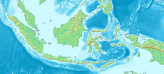
Indonesia is an archipelagic country located in Southeast Asia, lying between the Indian Ocean and the Pacific Ocean. It is located in a strategic location astride or along major sea lanes connecting East Asia, South Asia and Oceania. Indonesia is the largest archipelago in the world. Indonesia's various regional cultures have been shaped—although not specifically determined—by centuries of complex interactions with its physical environment.

Papua New Guinea, officially the Independent State of Papua New Guinea, is a country in Oceania that occupies the eastern half of the island of New Guinea and its offshore islands in Melanesia, a region of the southwestern Pacific Ocean north of Australia. Its capital, located along its southeastern coast, is Port Moresby. The western half of New Guinea forms the Indonesian provinces of Papua and West Papua. It is the world's third largest island country with 462,840 km2 (178,700 sq mi).

The geography of Papua New Guinea describes the eastern half of the island of New Guinea, the islands of New Ireland, New Britain and Bougainville, and smaller nearby islands. Together these make up the nation of Papua New Guinea in tropical Oceania, located in the western edge of the Pacific Ocean.

Port Moresby, also referred to as Pom City or simply Moresby, is the capital and largest city of Papua New Guinea and the largest city in the South Pacific outside of Australia and New Zealand. It is located on the shores of the Gulf of Papua, on the south-western coast of the Papuan Peninsula of the island of New Guinea. The city emerged as a trade centre in the second half of the 19th century. During World War II it was a prime objective for conquest by the Imperial Japanese forces during 1942–43 as a staging point and air base to cut off Australia from Southeast Asia and the Americas.
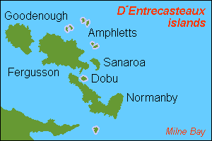
D'Entrecasteaux Islands are situated near the eastern tip of New Guinea in the Solomon Sea in Milne Bay Province of Papua New Guinea. The group spans a distance of 160 km (99 mi), has a total land area of approximately 3,100 km2 (1,197 sq mi) and is separated from the Papua New Guinea mainland by the 30 km (19 mi) wide Ward Hunt Strait in the north and the 18 km (11 mi) wide Goschen Strait in the south. D'Entrecasteaux Islands show signs of volcanism.
Oro Province, formerly Northern Province, is a coastal province of Papua New Guinea. The provincial capital is Popondetta. The province covers 22,800 km2, and has 176,206 inhabitants. The province shares land borders with Morobe Province to the northwest, Central Province to the west and south, and Milne Bay Province to the southeast. The province is located within the Papuan Peninsula.

Normanby Island is a volcanic 1,000-square-kilometre (390 sq mi), L-shaped island, the southernmost island in the D'Entrecasteaux Islands group. It is part of Milne Bay Province, Papua New Guinea.

Misima is a volcanic island in the northwest of Louisiade Archipelago within Milne Bay Province of Papua New Guinea.

Manokwari is a coastal town and the capital of the Indonesian province of West Papua. It is one of only four provincial capitals of Indonesia without a city status. It is also the administrative seat of Manokwari Regency. However, under proposals currently under consideration by the Indonesian Parliament, it is planned to split Manokwari town off from the regency and turn it into a separate city. The majority of Manokwari residents are Christians and the town is one of the seats of the Roman Catholic Diocese of Manokwari–Sorong.

Goodenough Island in the Solomon Sea, also known as Nidula Island, is the westernmost of the three large islands of the D'Entrecasteaux Islands in Milne Bay Province of Papua New Guinea. It lies to the east of mainland New Guinea and southwest of the Trobriand Islands. It is roughly circular in shape, measuring 39 by 26 kilometres with an area of 687 square kilometres (265 sq mi) and a shoreline of 116 kilometres (72 mi). From a coastal belt varying in width from 2 to 10 kilometres in width, the island rises sharply to the summit of Mount Vineuo, 2,536 metres (8,320 ft) above sea level, making it one of the most precipitous islands in the world. The small outlier Wagifa Island lies to the south-east of the island, and is included within Goodenough's administration.

The New Guinea campaign of the Pacific War lasted from January 1942 until the end of the war in August 1945. During the initial phase in early 1942, the Empire of Japan invaded the Australian-administered Mandated Territory of New Guinea and the Australian Territory of Papua and overran western New Guinea, which was a part of the Netherlands East Indies. During the second phase, lasting from late 1942 until the Japanese surrender, the Allies—consisting primarily of Australian forces—cleared the Japanese first from Papua, then the Mandate and finally from the Dutch colony.

Jacquinot Bay is a bay in East New Britain Province, south-eastern New Britain, Papua New Guinea, at 5.5666667°S 151.5°E. It is near the mountain where twenty-eight people died when a Royal Australian Air Force plane crashed in November 1945. To its west is the Gasmata Bay and the Wide Bay and Rabaul Bay are situated to the north-east.
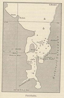
Finschhafen is a town 80 kilometers (50 mi) east of Lae on the Huon Peninsula in Morobe Province of Papua New Guinea. The town is commonly misspelt as Finschafen or Finschaven. During World War II, the town was also referred to as Fitch Haven in the logs of some U.S. Navy men.

The continent of Australia, sometimes known in technical contexts by the names Sahul, Australinea, or Meganesia to distinguish it from the country of Australia, consists of the landmasses which sit on Australia's continental plate. The name "Sahul" takes its name from the Sahul Shelf, which is part of the continental shelf of the Australian continent. The continent includes mainland Australia, Tasmania, and the island of New Guinea, which consists of Papua New Guinea and Western New Guinea. Situated in the geographical region of Oceania, Australia is the smallest of the seven traditional continents.

New Guinea is the world's second-largest island and, with an area of 785,753 km2 (303,381 sq mi), the largest island in the Southern Hemisphere. Located in Melanesia in the southwestern Pacific Ocean, it is separated by the 150-kilometre wide Torres Strait from the Australian continent. Numerous smaller islands are located to the west and east. The eastern half of the island is the major land mass of the independent state of Papua New Guinea. The western half, known as Western New Guinea or West Papua, forms a part of Indonesia and is organized as the provinces of Papua and West Papua.

Buin is a town on Bougainville Island, and the capital of the South Bougainville District, in the Autonomous Region of Bougainville, in eastern Papua New Guinea. The island is in the northern Solomon Islands Archipelago of the Melanesia region, in the South Pacific Ocean.
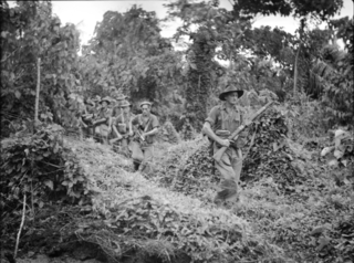
The Battle of Wide Bay–Open Bay was a battle during the New Britain campaign of the Second World War. Following the arrival of the Australians on New Britain in late 1944, replacing the US garrison on the island, they began a limited offensive against the Japanese forces on the island. Pushing east from the positions previously captured by the US troops earlier in the year, after landing at Jacquinot Bay on the southern coast in November, the Australians began advancing across the island towards the Gazelle Peninsula, where they sought to isolate the numerically superior Japanese garrison. This advance was effected along two axes: Cape Hoskins to Open Bay on the northern coast, and Jacquinot Bay to Wide Bay on the southern. Once the Australians had secured a line across the island between Wide Bay and Open Bay in March and April 1945, the fighting on New Britain died down as the Australians sought to contain the larger Japanese garrison while limiting their own casualties. This situation lasted until the end of the war in August 1945.
Gasmata is a village on the southern coast of New Britain, Papua New Guinea located at 6° 16' 60S 150° 19' 60E. There is a Gasmata Airport in Surumi Peninsula area adjacent. The village is administered under Gasmata Rural LLG in East New Britain Province.

Deforestation in Papua New Guinea has been extensive in recent decades and is continuing at an estimated rate of 1.4% of tropical forest being lost annually. Deforestation in Papua New Guinea is mainly a result of illegal logging, which contributed to 70-90% of all timber exports, one of the highest rates in the world. Illegal logging is linked to corruption, environmental issues and human rights concerns.

Ataliklikun Bay is a bay of East New Britain Province, Papua New Guinea, opening into the Bismarck Sea. It is located in the northern part of New Britain, south-west of Lassul Bay and to the west of Cape Lambert and Rabaul. Urara Island is located in the northern part of the bay. The Raulavat plantation lies in the eastern part of its 25-mile shoreline. The villagers along the shore reportedly speak the Minigir language and the Masava dialect of Tolai. The United States Hydrographic Office said "a reef awash, about 200 yards long east and west, with 15 and 19 fathoms around, on which the steamer Seestem struck in 1909, lies in the south-west part of Ataliklikun Bay."
References
- ↑ "Open Bay". Pacific Wrecks. Retrieved 16 April 2016.
- ↑ "Open Bay timber area map". Department of Forestry. Retrieved 16 April 2016.
- ↑ Dennis, Peter; et al. (2008). The Oxford Companion to Australian Military History. Melbourne: Oxford University Press. p. 390. ISBN 978-0-19-551784-2.
- ↑ "Climate: Open Bay". Climate-Data.org. Retrieved 20 October 2020.
Coordinates: 4°48′S151°32′E / 4.80°S 151.54°E
| | This West New Britain Province geography article is a stub. You can help Wikipedia by expanding it. |