Wieniawa, Masovian Voivodeship

Last updated
Wieniawa
Village
Poland adm location map.svg
Red pog.svg
Wieniawa
Coordinates: 51°22′N20°48′E / 51.367°N 20.800°E / 51.367; 20.800
Country Flag of Poland.svg Poland
Voivodeship Masovian
County Przysucha
Gmina Wieniawa

Wieniawa [vjɛˈɲava] is a village in Przysucha County, Masovian Voivodeship, in east-central Poland (historic Lesser Poland). It is the seat of the gmina (administrative district) called Gmina Wieniawa. [1] It lies approximately 13 kilometres (8 mi) east of Przysucha and 96 km (60 mi) south of Warsaw.

Village Small clustered human settlement smaller than a town

A village is a clustered human settlement or community, larger than a hamlet but smaller than a town, with a population ranging from a few hundred to a few thousand. Though villages are often located in rural areas, the term urban village is also applied to certain urban neighborhoods. Villages are normally permanent, with fixed dwellings; however, transient villages can occur. Further, the dwellings of a village are fairly close to one another, not scattered broadly over the landscape, as a dispersed settlement.
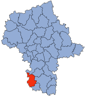
Przysucha County County in Masovian, Poland

Przysucha County is a unit of territorial administration and local government (powiat) in Masovian Voivodeship, east-central Poland. It came into being on January 1, 1999, as a result of the Polish local government reforms passed in 1998. Its administrative seat and only town is Przysucha, which lies 98 kilometres (61 mi) south of Warsaw.

Masovian Voivodeship Voivodeship in Poland

Mazovian Voivodeship or Mazovia Province is the largest and most populous of the 16 Polish provinces, or voivodeships, created in 1999. It occupies 35,579 square kilometres (13,737 sq mi) of east-central Poland, and has 5,324,500 inhabitants. Its principal cities are Warsaw in the centre of the Warsaw metropolitan area, Radom (226,000) in the south, Płock (127,000) in the west, Siedlce (77,000) in the east, and Ostrołęka (55,000) in the north. The capital of the voivodeship is the national capital, Warsaw.

The history of the village dates back to the late Middle Ages, and its original name was Klodno. The Roman Catholic parish at Klodno was founded in 1365, but the history of the first church here dates back to 1264. In the second half of the 15th century, the village was purchased by the Wieniawita noble family, which changed its name to Wieniawa.

Middle Ages Period of European history from the 5th to the 15th century

In the history of Europe, the Middle Ages lasted from the 5th to the 15th century. It began with the fall of the Western Roman Empire and merged into the Renaissance and the Age of Discovery. The Middle Ages is the middle period of the three traditional divisions of Western history: classical antiquity, the medieval period, and the modern period. The medieval period is itself subdivided into the Early, High, and Late Middle Ages.

<i>Szlachta</i> legally privileged noble class in the Kingdom of Poland, and in the Grand Duchy of Lithuania

The szlachta was a legally privileged noble class in the Kingdom of Poland, and in the Grand Duchy of Lithuania. After the Union of Lublin in 1569, the Grand Duchy and its neighbouring Kingdom became a single state, the Polish–Lithuanian Commonwealth.

The village is famous for its parish church, which was founded in the year 1511 by father Stanislaw Mlodecki, in the location of the 13th-century wooden church. The oldest part of the church is a late Gothic presbytery, together with St. Stanislaus chapel. The nave with two side altars were built in 1703, and the whole complex was renovated in 1909–12.

Nave main body of a church

The nave is the central part of a church, stretching from the main entrance or rear wall, to the transepts, or in a church without transepts, to the chancel. When a church contains side aisles, as in a basilica-type building, the strict definition of the term "nave" is restricted to the central aisle. In a broader, more colloquial sense, the nave includes all areas available for the lay worshippers, including the side-aisles and transepts. Either way, the nave is distinct from the area reserved for the choir and clergy.

Altar structure upon which offerings such as sacrifices are made for religious purposes

An altar is a structure upon which offerings such as sacrifices are made for religious purposes. Altars are found at shrines, temples, churches and other places of worship. They are used particularly in Christianity, Buddhism, Hinduism and Judaism used such a structure until the destruction of the Second Temple. Many historical faiths also made use of them, including Roman, Greek and Norse religion.

The most interesting element in the church is its main altar, known as the Wieniawa Polyptych, which comes from the year 1544, and is in Renaissance style. The names of creators of the main altar are not known, and the Wieniawa Polyptych is regarded as one of the finest examples of Renaissance art in the Radom Land. It consists of three parts, illustrating the life and death of Saint Stanislaus of Szczepanow, Bishop and Martyr.

Polyptych painted or carved work consisting of multiple panels

A polyptych is a painting which is divided into sections, or panels. Specifically, a "diptych" is a two-part work of art; a "triptych" is a three-part work; a tetraptych or quadriptych has four parts; pentaptych five; hexaptych six; heptaptych seven; and octaptych eight parts.

Renaissance European cultural period, 14th to 17th century

The Renaissance is a period in European history, covering the span between the 14th and 17th centuries and marking the transition from the Middle Ages to modernity. The traditional view focuses more on the early modern aspects of the Renaissance and argues that it was a break from the past, but many historians today focus more on its medieval aspects and argue that it was an extension of the middle ages.

See also

Related Research Articles

Brudnów, Masovian Voivodeship Village in Masovian, Poland

Brudnów is a village in the administrative district of Gmina Wieniawa, within Przysucha County, Masovian Voivodeship, in east-central Poland. It lies approximately 4 kilometres (2 mi) north of Wieniawa, 15 km (9 mi) east of Przysucha, and 92 km (57 mi) south of Warsaw.

Głogów, Masovian Voivodeship Village in Masovian, Poland

Głogów is a village in the administrative district of Gmina Wieniawa, within Przysucha County, Masovian Voivodeship, in east-central Poland. It lies approximately 8 kilometres (5 mi) north-east of Wieniawa, 19 km (12 mi) east of Przysucha, and 90 km (56 mi) south of Warsaw.

Jabłonica, Masovian Voivodeship Village in Masovian, Poland

Jabłonica is a village in the administrative district of Gmina Wieniawa, within Przysucha County, Masovian Voivodeship, in east-central Poland. It lies approximately 2 kilometres (1 mi) south of Wieniawa, 13 km (8 mi) east of Przysucha, and 97 km (60 mi) south of Warsaw.

Kaleń, Przysucha County Village in Masovian, Poland

Kaleń is a village in the administrative district of Gmina Wieniawa, within Przysucha County, Masovian Voivodeship, in east-central Poland. It lies approximately 6 kilometres (4 mi) north-east of Wieniawa, 17 km (11 mi) east of Przysucha, and 92 km (57 mi) south of Warsaw.

Kamień Mały, Masovian Voivodeship Village in Masovian, Poland

Kamień Mały is a village in the administrative district of Gmina Wieniawa, within Przysucha County, Masovian Voivodeship, in east-central Poland. It lies approximately 4 kilometres (2 mi) west of Wieniawa, 10 km (6 mi) east of Przysucha, and 95 km (59 mi) south of Warsaw.

Komorów, Przysucha County Village in Masovian, Poland

Komorów is a village in the administrative district of Gmina Wieniawa, within Przysucha County, Masovian Voivodeship, in east-central Poland. It lies approximately 5 kilometres (3 mi) west of Wieniawa, 9 km (6 mi) east of Przysucha, and 95 km (59 mi) south of Warsaw.

Konary, Przysucha County Settlement in Masovian, Poland

Konary is a settlement in the administrative district of Gmina Wieniawa, within Przysucha County, Masovian Voivodeship, in east-central Poland. It lies approximately 6 kilometres (4 mi) north-east of Wieniawa, 17 km (11 mi) east of Przysucha, and 90 km (56 mi) south of Warsaw.

Koryciska, Przysucha County Village in Masovian, Poland

Koryciska is a village in the administrative district of Gmina Wieniawa, within Przysucha County, Masovian Voivodeship, in east-central Poland. It lies approximately 3 kilometres (2 mi) south-east of Wieniawa, 16 km (10 mi) east of Przysucha, and 97 km (60 mi) south of Warsaw.

Pogroszyn Village in Masovian, Poland

Pogroszyn is a village in the administrative district of Gmina Wieniawa, within Przysucha County, Masovian Voivodeship, in east-central Poland. It lies approximately 4 kilometres (2 mi) south of Wieniawa, 15 km (9 mi) east of Przysucha, and 99 km (62 mi) south of Warsaw.

Romualdów Village in Masovian, Poland

Romualdów is a village in the administrative district of Gmina Wieniawa, within Przysucha County, Masovian Voivodeship, in east-central Poland. It lies approximately 7 kilometres (4 mi) north-west of Wieniawa, 8 km (5 mi) north-east of Przysucha, and 93 km (58 mi) south of Warsaw.

Ryków, Masovian Voivodeship Village in Masovian, Poland

Ryków is a village in the administrative district of Gmina Wieniawa, within Przysucha County, Masovian Voivodeship, in east-central Poland. It lies approximately 4 kilometres (2 mi) south of Wieniawa, 13 km (8 mi) east of Przysucha, and 100 km (62 mi) south of Warsaw.

Skrzynno, Masovian Voivodeship Village in Masovian, Poland

Skrzynno is a village in the administrative district of Gmina Wieniawa, within Przysucha County, Masovian Voivodeship, in east-central Poland. It lies approximately 6 kilometres (4 mi) west of Wieniawa, 8 km (5 mi) east of Przysucha, and 97 km (60 mi) south of Warsaw. The village has a population of 300.

Sokolniki Mokre Village in Masovian, Poland

Sokolniki Mokre is a village in the administrative district of Gmina Wieniawa, within Przysucha County, Masovian Voivodeship, in east-central Poland. It lies approximately 3 kilometres (2 mi) west of Wieniawa, 11 km (7 mi) east of Przysucha, and 96 km (60 mi) south of Warsaw.

Sokolniki Suche Village in Masovian, Poland

Sokolniki Suche is a village in the administrative district of Gmina Wieniawa, within Przysucha County, Masovian Voivodeship, in east-central Poland. It lies approximately 3 kilometres (2 mi) north-west of Wieniawa, 12 km (7 mi) east of Przysucha, and 94 km (58 mi) south of Warsaw.

Wola Brudnowska Village in Masovian, Poland

Wola Brudnowska is a village in the administrative district of Gmina Wieniawa, within Przysucha County, Masovian Voivodeship, in east-central Poland. It lies approximately 6 kilometres (4 mi) north of Wieniawa, 15 km (9 mi) east of Przysucha, and 90 km (56 mi) south of Warsaw.

Wydrzyn, Masovian Voivodeship Village in Masovian, Poland

Wydrzyn is a village in the administrative district of Gmina Wieniawa, within Przysucha County, Masovian Voivodeship, in east-central Poland. It lies approximately 6 kilometres (4 mi) west of Wieniawa, 7 km (4 mi) east of Przysucha, and 97 km (60 mi) south of Warsaw.

Zadąbrów Village in Masovian, Poland

Zadąbrów is a village in the administrative district of Gmina Wieniawa, within Przysucha County, Masovian Voivodeship, in east-central Poland. It lies approximately 9 kilometres (6 mi) north-east of Wieniawa, 20 km (12 mi) east of Przysucha, and 90 km (56 mi) south of Warsaw.

Zagórze, Przysucha County Village in Masovian, Poland

Zagórze is a village in the administrative district of Gmina Wieniawa, within Przysucha County, Masovian Voivodeship, in east-central Poland. It lies approximately 6 kilometres (4 mi) north-west of Wieniawa, 9 km (6 mi) north-east of Przysucha, and 93 km (58 mi) south of Warsaw.

Żuków, Przysucha County Village in Masovian, Poland

Żuków is a village in the administrative district of Gmina Wieniawa, within Przysucha County, Masovian Voivodeship, in east-central Poland. It lies approximately 4 kilometres (2 mi) south-west of Wieniawa, 10 km (6 mi) east of Przysucha, and 98 km (61 mi) south of Warsaw.

Plec, Poland Village in Masovian, Poland

Plec is a village in the administrative district of Gmina Wieniawa, within Przysucha County, Masovian Voivodeship, in east-central Poland. It lies approximately 6 kilometres (4 mi) north of Wieniawa, 14 km (9 mi) north-east of Przysucha, and 90 km (56 mi) south of Warsaw.

References


Coordinates: 51°22′N20°48′E / 51.367°N 20.800°E / 51.367; 20.800

Geographic coordinate system Coordinate system

A geographic coordinate system is a coordinate system that enables every location on Earth to be specified by a set of numbers, letters or symbols. The coordinates are often chosen such that one of the numbers represents a vertical position and two or three of the numbers represent a horizontal position; alternatively, a geographic position may be expressed in a combined three-dimensional Cartesian vector. A common choice of coordinates is latitude, longitude and elevation. To specify a location on a plane requires a map projection.