Wiesenaue | |
|---|---|
Location of Wiesenaue within Havelland district 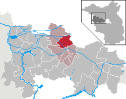 | |
 Location of Wiesenaue | |
 Wiesenaue  Wiesenaue | |
| Coordinates: 52°42′N12°37′E / 52.700°N 12.617°E | |
| Country | Germany |
| State | Brandenburg |
| District | Havelland |
| Municipal assoc. | Friesack |
| Subdivisions | 4 Ortsteile |
| Government | |
| • Mayor (2024–29) | Heiko Gräning [1] |
| Area | |
• Total | 46.73 km2 (18.04 sq mi) |
| Elevation | 27 m (89 ft) |
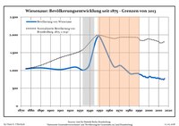
| Population (2023-12-31) [2] | |
• Total | 795 |
| • Density | 17.0/km2 (44.1/sq mi) |
| Time zone | UTC+01:00 (CET) |
| • Summer (DST) | UTC+02:00 (CEST) |
| Postal codes | 14662 |
| Dialling codes | 033237, 033235 |
| Vehicle registration | HVL |
| Website | Amtsseite über Wiesenaue |
Wiesenaue is a municipality in the Havelland district, in Brandenburg, Germany.