
Charing Cross Road is a street in central London running immediately north of St Martin-in-the-Fields to St Giles Circus and then becomes Tottenham Court Road. It leads from the north in the direction of Charing Cross at the south side of Trafalgar Square. It connects via St Martin's Place and the motorised east side of the square.

Baker Street is a street in the Marylebone district of the City of Westminster in London. It is named after builder William Baker, who laid out the street in the 18th century. The street is most famous for its connection to the fictional detective Sherlock Holmes, who lived at a fictional 221B Baker Street address on the north of the street. The area was originally high class residential, but now is mainly occupied by commercial premises.
Great Portland Street in Marylebone, in the West End of London, links Oxford Street with the A501 Marylebone Road. The street, which is part of a broader rectilinear street pattern, includes the Embassy of the Democratic Republic of the Congo. and a number of small independent shops.

Long Acre is a street in the City of Westminster in central London. It runs from St Martin's Lane, at its western end, to Drury Lane in the east. The street was completed in the early 17th century and was once known for its coach-makers, and later for its car dealers.

Turl Street is a historic street in central Oxford, England.

Welbeck Street is a street in the West End, central London. It has historically been associated with the medical profession.

Wimpole Street is a street in Marylebone, central London. Located in the City of Westminster, it is associated with private medical practice and medical associations. No. 1 Wimpole Street is an example of Edwardian baroque architecture, completed in 1912 by architect John Belcher as the home of the Royal Society of Medicine. 64 Wimpole Street is the headquarters of the British Dental Association.
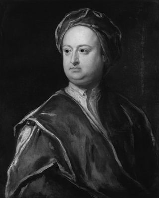
Edward Harley, 2nd Earl of Oxford and Earl Mortimer, styled Lord Harley between 1711 and 1724, was a British politician, bibliophile, collector and patron of the arts.

Cavendish Square is a public garden square in Marylebone in the West End of London. It has a double-helix underground commercial car park. Its northern road forms ends of four streets: of Wigmore Street that runs to Portman Square in the much larger Portman Estate to the west; of Harley Street which runs an alike distance; of Chandos Street which runs for one block and; of Cavendish Place which runs the same. The south side itself is modern: the rear façade and accesses to a flagship department store and office block. On the ground floors facing are Comptoir Libanais, Royal Bank of Scotland and Pret a Manger premises.

The A40 is a major trunk road connecting London to Fishguard, Wales. The A40 in London passes through seven London Boroughs: the City of London, Camden, Westminster, Kensington & Chelsea, Hammersmith & Fulham, Ealing and Hillingdon, to meet the M40 motorway junction 1 at Denham, Buckinghamshire.

Park End Street is a street in central Oxford, England, to the west of the centre of the city, close to the railway station at its western end.

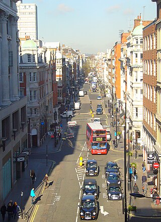
Marylebone is a district in the West End of London, in the City of Westminster. Oxford Street, Europe's busiest shopping street, forms its southern boundary.
Charles H Worley (1853–1906) was a British architect.
The Howard de Walden Estate is a property estate in Marylebone, London, owned by the Howard de Walden family. As of 2020 the estate was reported to be worth £4.7 billion.

Weymouth Street lies in the Marylebone district of the City of Westminster and connects Marylebone High Street with Great Portland Street. The area was developed in the late 18th century by Henrietta Cavendish Holles and her husband Edward Harley, 2nd Earl of Oxford. This part of Marylebone originally belonged to the Manor of Tyburn which existed at the time of the Domesday Book (1086).

Devonshire Street is a street in the City of Westminster, London. Adjoining Harley Street, it is known for the number of medical establishments it contains.

Marylebone Lane is one of the original streets of the Marylebone district of the City of Westminster, London. It runs from Oxford Street in the south to Marylebone High Street in the north, its winding shape following the course of the River Tyburn that it once ran alongside and pre-dating the grid pattern of the other streets in the area. Today the lane is largely composed of small shops, cafes and restaurants with some small apartment blocks. There are some larger commercial buildings at the southern end near Oxford Street.

Henrietta Place, originally known as Henrietta Street, is a street in Marylebone in the City of Westminster in central London that runs from Marylebone Lane in the east to Cavendish Square in the west. It is joined on the north side by Welbeck Street and Wimpole Street, and on the south side by Vere Street, Chapel Place, and Old Cavendish Street.
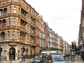
This is a list of the etymology of street names in the London district of Marylebone. The following utilises the generally accepted boundaries of Marylebone viz. Marylebone Road to the north, Great Portland Street to the east, Marble Arch and Oxford Street to the south and Edgware Road to the west.

Wimpole Mews is a mews street in Marylebone, London W1, England. It is known for being a key location in the Profumo affair in the early 1960s.
