Related Research Articles

Shropshire is a landlocked historic county in the West Midlands region of England bordering Wales. Shropshire borders with the English counties of Cheshire to the north, Staffordshire to the east, Worcestershire to the southeast, and Herefordshire to the south, and bordering Wales with the counties of Wrexham and Powys to the west. A unitary authority of the same name was created in 2009, taking over from the previous county council and five district councils, now governed by Shropshire Council. The borough of Telford and Wrekin has been a separate unitary authority since 1998, but remains part of the ceremonial county.

Oswestry is a market town, civil parish and historic railway town in Shropshire, England, close to the Welsh border. It is at the junction of the A5, A483 and A495 roads.

Old Oswestry is a large early Iron Age hill fort in the Welsh Marches near Oswestry in north west Shropshire, England. The earthworks, which remain one of the best preserved hill forts in the UK, have been described as "The Stonehenge of the Iron Age Period". After the hill fort was abandoned, it was incorporated into Wat's Dyke by the Mercians during the Early Medieval period.

The Borough of Oswestry was a local government district with borough status in Shropshire, England, from medieval times until its abolition in 2009. Until 1974 the borough just covered the town of Oswestry itself. The borough was enlarged in 1974 to also include the surrounding rural area, although it was the smallest post-1974 district of Shropshire.

Durham Wildlife Trust, is a registered charity and was established in 1971, originally as the Durham County Conservation Trust, becoming Durham Wildlife Trust in 1988. The Trust operates across the area of the old County Durham, which today includes Darlington, Gateshead, South Tyneside and Sunderland.
The Leicestershire and Rutland Wildlife Trust (LRWT) is one of 46 wildlife trusts across the United Kingdom. It manages nature reserves in Leicestershire and Rutland, and was founded in 1956 as the Leicestershire and Rutland Trust for Nature Conservation. As of January 2018, it has over 16,000 members, a staff of about 25 and more than 500 volunteers. It is based in Leicester, and is managed by a Council of Trustees which is elected by the members. It is a charity which covers all aspects of nature conservation, and works to protect wild places and wildlife.
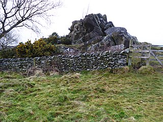
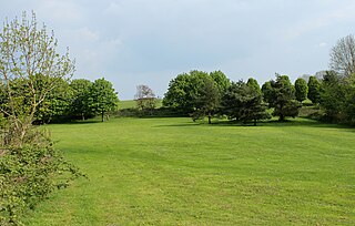
This large hill in the centre of Oswestry is a 3-hectare (7.4-acre) area consisting of acid grassland and naturally regenerated areas of woodland and scrub.

The Cambrian Heritage Railways is a heritage railway company, trust and society based at both Llynclys and Oswestry in its newly restored Oswestry railway station, Shropshire, England.

Telford Town Park is a park and Local Nature Reserve in Telford in Shropshire. In 2015, it was voted "UK's Best Park" in the inaugural public competition organised by Fields in Trust

Park Hall Stadium is a football stadium to the north-east of Oswestry, Shropshire, England. It was opened by Shropshire County Council in 1993, originally as the home of Oswestry Town. In 2003, Oswestry Town merged with Total Network Solutions F.C. (TNS) to form current Cymru Premier team The New Saints. The newly merged club moved to Park Hall from Total Network Solutions' Recreation Ground.

Shropshire Council is the local authority of Shropshire, in England, comprising the ceremonial county of Shropshire except Telford and Wrekin. It is a unitary authority, having the powers of a non-metropolitan county and district council combined.
Colemere Countryside Site is a countryside heritage site. Due to its important conservation status it has two key designations being a Site of Special Scientific Interest (SSSI) and an internationally important Ramsar wetland site. 3 miles (4.8 km) south-east of Ellesmere, Shropshire.

Ifton Meadows is a Local Nature Reserve north of Oswestry in the county of Shropshire, England.

Donington and Albrighton is a local nature reserve being a valuable site for wildlife and recreation in Shropshire, it has a historical reference as it is the site of St Cuthberts Well which was believed to hold powers to cure the blind.
Rea Brook Valley is a country park, and Local Nature Reserve located in the town of Shrewsbury in Shropshire and is recognised nationwide as an important site for wildlife. This park is also known for its history in the Severn Valley Railway line. The Rea Brook is the watercourse that flows through the park.
Oswestry Race Course is a historic racecourse on ‘Cyrn y Bwch’ hill close to Oswestry in Shropshire that was used by the Welsh and English to socialise and race horses. Covering an area of 22 hectares, the course was closed to racing in 1848 and is now an area of common land for recreation. It is a well travelled walking route because Offa's Dyke Path passes through the site, although the dyke itself lies to the west.

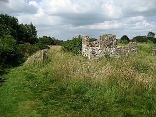
Oswestry Castle is a medieval castle in the town of Oswestry, Shropshire, England. The castle has also been known as, or recorded in historical documents as: Album Monasterium; Blancminster; Blankmouster; Blancmustier; Croes Oswald; L'Oeuvre; L'uvre; Castle Loure; Luure; Luvre; Lvvre: Castle Philip; Oswaldestre; Meresberie.
South Purdown, Bristol, is an ancient green space located in north Bristol, England. The area of land is bordered by central Muller Road, Sir Johns Lane Allotment site, Stoke Park, Lockleaze Open Space and the Priory Hospital, and has been designated a Site of Nature Conservation Interest and an important wildlife corridor.

Muston Meadows is an 8.8-hectare (22-acre) biological Site of Special Scientific Interest south of Muston in Leicestershire. It is also a National Nature Reserve and a Nature Conservation Review site.

Oswestry Guildhall is a municipal building in Bailey Head in Oswestry, Shropshire, England. The structure, which was the meeting place of Oswestry Municipal Borough Council, is a Grade II listed building.
References
- 1 2 BBC Shropshire "Oswestry Town Green gets £170,000 makeover", 16 February 2010. Retrieved 2013-08-07.
- 1 2 3 4 Shropshire Council "Wilfred Owen Green". Retrieved 2013-08-07.
- ↑ Natural England "Natural Assets Newsletter". Retrieved 2013-08-07.
- 1 2 Shropshire Council "Wilfred Owen Green" Date retrieved:7/8/13