
Ithaca Tompkins International Airport is a county-owned airport located in the Town of Lansing, three miles northeast of Ithaca, the county seat and only city in Tompkins County, New York. The National Plan of Integrated Airport Systems for 2025–2029 categorized it as a primary commercial service facility. Federal Aviation Administration records say the airport had 60,848 passenger boardings in 2023.

Martin State Airport is a joint civil-military public use airport located nine nautical miles east of the central business district of Baltimore, in Baltimore County, Maryland, United States. The facility is located within the census-designated place of Middle River on Maryland State Highway 150, near the intersection of Maryland State Highway 700. The Maryland Aviation Administration operates the airport on behalf of the Maryland Department of Transportation. MTN is a general aviation relief airport.

Bozeman Yellowstone International Airport is located in Belgrade, Montana, United States, eight miles northwest of Bozeman. Owned by the Gallatin Airport Authority, it has been Montana's busiest airport since 2013.

Montgomery Regional Airport is a civil-military airport seven miles southwest of Montgomery, the capital of Alabama. Owned by the Montgomery Airport Authority, it is used for general aviation and military aviation, and sees two airlines.

Hilton Head Airport is on Hilton Head Island, in Beaufort County, South Carolina, United States. Also known as Hilton Head Island Airport, it is owned by Beaufort County.

Grant County International Airport is a public use airport located six miles (10 km) northwest of the central business district of Moses Lake in Grant County, Washington, United States. Formerly a military facility, the airport is owned by the Port of Moses Lake, and its 13,500-foot (4,110 m) runway is the 17th longest in the U.S.

The Pompano Beach Airpark is a public airport located one mile (1.6 km) northeast of the central business district of Pompano Beach, in Broward County, Florida, United States. The airport is publicly owned by the City of Pompano Beach.

Danbury Municipal Airport is a public use general aviation and commercial airport located three miles (5 km) southwest of the central business district of Danbury, in Fairfield County, Connecticut, United States. The airport opened in 1930. It is currently run by the City of Danbury under the management of Michael Safranek. It is included in the Federal Aviation Administration (FAA) National Plan of Integrated Airport Systems for 2017–2021, in which it is categorized as a regional reliever airport facility.
Nevada County Air Park is a public airport in Nevada County, California, three miles east of Grass Valley, California. It is also known as Nevada County Airport.

Concord–Padgett Regional Airport is a city-owned, public-use airport located 7 nmi west of the central business district of Concord, a city in Cabarrus County, North Carolina, United States. According to the FAA's National Plan of Integrated Airport Systems for 2009–2013, it is classified as a reliever airport for Charlotte Douglas International Airport.
Charlotte–Monroe Executive Airport is a public use airport located five nautical miles (9 km) northwest of the central business district of Monroe, a city in Union County, North Carolina, United States. It is owned by the City of Monroe and was formerly known as Monroe Regional Airport.

Griffith-Merrillville Airport is a public-use airport two miles east of Griffith, in Lake County, Indiana, United States. Until 2023, it was privately owned by Griffith Aviation, Inc.
London-Corbin Airport is in Laurel County, Kentucky, three miles south of London and about 12 miles north of Corbin. The airport is operated by both cities.

Madras Municipal Airport, formerly City-County Airport, is a public use airport located three nautical miles (6 km) northwest of the central business district of Madras, a city in Jefferson County, Oregon, United States. According to the FAA's National Plan of Integrated Airport Systems for 2009–2013, it is classified as a general aviation airport.
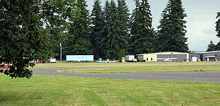
Scappoose Airport is a public use airport located one nautical mile (1.85 km) northeast of the central business district of Scappoose, in Columbia County, Oregon, United States. It is owned and operated by the Port of Columbia County, an Oregon port district and municipal corporation, on behalf of district residents. According to the FAA's National Plan of Integrated Airport Systems for 2009–2013, it is categorized as a general aviation airport.
Robbins Field is a public use airport located five nautical miles northeast of the central business district of Oneonta, a city in Blount County, Alabama, United States. It is owned by the City of Oneonta and Blount County. According to the FAA's National Plan of Integrated Airport Systems for 2009–2013, it is categorized as a general aviation facility.

Cut Bank Municipal Airport is three miles southwest of Cut Bank, in Glacier County, Montana, United States. It is owned by Cut Bank and Glacier County.

Grand Strand Airport is a county-owned, public-use airport located one nautical mile (1.85 km) northwest of the central business district of North Myrtle Beach, in Horry County, South Carolina, United States. The name Grand Strand refers to a nearby 60-mile stretch of beach; its code CRE refers to nearby Crescent Beach.
Pratt Regional Airport is a public airport five miles north of Pratt, in Pratt County, Kansas. Previously known as Pratt Industrial Airport, it is on the site of the former Pratt Army Airfield.

Carroll County Airport is a county-owned, public-use airport in Carroll County, Arkansas, United States. It is located three nautical miles (6 km) west of the central business district of Berryville, Arkansas. This airport is included in the National Plan of Integrated Airport Systems for 2011–2015, which categorized it as a general aviation facility.
