William Bennett (Australian engineer)

Last updated

William Christopher Bennett (4 July 1824 – 29 September 1889) [1] was an Irish born surveyor and engineer active in colonial Australia, Commissioner and Engineer-in-Chief for Roads and Bridges in New South Wales.

New South Wales State of Australia

New South Wales is a state on the east coast of Australia. It borders Queensland to the north, Victoria to the south, and South Australia to the west. Its coast borders the Tasman Sea to the east. The Australian Capital Territory is an enclave within the state. New South Wales' state capital is Sydney, which is also Australia's most populous city. In September 2018, the population of New South Wales was over 8 million, making it Australia's most populous state. Just under two-thirds of the state's population, 5.1 million, live in the Greater Sydney area. Inhabitants of New South Wales are referred to as New South Welshmen.

Contents

Early life

Bennett was born in Dublin, Ireland, the eldest son of Ignatius Bennett, a traffic manager, and his wife Alicia, née Garvey. [1] Bennett was employed as a pupil on various territorial and railway surveys and other works in Ireland from 1840 to 1845, and as assistant engineer in charge of drainage works, under the Board of Public Works in Ireland, from 1845 to 1852. [2]

Dublin capital and largest city in Ireland

Dublin is the capital and largest city of Ireland. It is on the east coast of Ireland, in the province of Leinster, at the mouth of the River Liffey, and is bordered on the south by the Wicklow Mountains. It has an urban area population of 1,173,179, while the population of the Dublin Region, as of 2016, was 1,347,359, and the population of the Greater Dublin area was 1,904,806.

Surveyor

During 1852-3 Bennett was employed in reporting on the navigation of the Rhone and Saône, and making surveys and reports on the navigation of the Magdalena River, with connecting canals, roads or railways, in New Grenada. Bennett was engaged on the International (French, American and English) Ship Canal Survey at the Darién Gap, in 1854, having charge of the English survey on the Pacific side in the absence of Mr. Forde, M.I.C.E., on which occasion Bennett received the thanks of the American Government for having, in conjunction with Lieut. Forsythe and a party from H.M.S. Virago, relieved Lieut. Isaac Strain, United States navy, and his missing exploring party, at no small personal risk. [2]

Saône river of France

The Saône is a river of eastern France. It is a right tributary of the Rhône, rising at Vioménil in the Vosges department and joining the Rhône in Lyon, just south of the Presqu'île.

Magdalena River river in Colombia

The Magdalena River is the principal river of Colombia, flowing northward about 1,528 kilometres (949 mi) through the western half of the country. It takes its name from the biblical figure Mary Magdalene. It is navigable through much of its lower reaches, in spite of the shifting sand bars at the mouth of its delta, as far as Honda, at the downstream base of its rapids. It flows through the Magdalena River Valley.

Republic of New Granada former republic in South America and Central America between 1831–1858

The Republic of New Granada was a centralist republic consisting primarily of present-day Colombia and Panama with smaller portions of today's Nicaragua, Costa Rica, Ecuador, Venezuela, Peru, and Brazil. It was created after the dissolution in 1830 of Gran Colombia, with the secession of Ecuador and Venezuela and was formed by the departments of Boyaca, Cauca, Cundinamarca, Magdalena, and Istmo, all parts of the present Republic of Colombia. except Istmo, which is part of present-day Panama). In November 1831, those departments created the Republic of New Granada, but nothing was established about a flag. Old flags were confirmed provisional by the National Convention of 17 December 1831. However, it is not clear what flag it was: Restrepo believes that it is the flag with two cornucopias of Gran Colombia. While new flags were discussed, some proposals were issued. On 9 May 1834, the national flag was adopted and was used until 26 November 1861, with the Gran Colombian colors in Veles' arrangement. The merchant ensign had the eight-pointed star in white.

Career in Australia

At the end of 1854 Bennett proceeded, viâ New Zealand, to New South Wales, and was for about ten months attached to the Survey Department as an assistant surveyor. In April 1856 he was appointed assistant engineer to the Commission for the Sewerage and Water Supply of Sydney; was engaged in the Railway Department, New South Wales, from January to September 1857, and was then transferred to the Department of Roads, which, as assistant engineer, and ultimately as engineer, he assisted Captain (afterwards Colonel) Ben Martindale, C.B., R.E., in organising. [2] Bennett left the colony for Europe in January 1861, and on his return he was appointed, in November 1862, commissioner and engineering-chief for roads, New South Wales, which office he occupied until a short time before his death. Bennett designed the Prince Alfred Bridge over the Murrumbidgee River, and was engineer for the Denison Bridge over the Macquarie River, New South Wales. Bennett was also occasionally employed on the western goldfields and narrow gauge railways, the water supply of Sydney, and the drainage of the Hunter River. Bennett died on 29 September 1889, at the age of sixty-five [2] in St Leonards, New South Wales. [1]

New Zealand Country in Oceania

New Zealand is a sovereign island country in the southwestern Pacific Ocean. The country geographically comprises two main landmasses—the North Island, and the South Island —and around 600 smaller islands. New Zealand is situated some 2,000 kilometres (1,200 mi) east of Australia across the Tasman Sea and roughly 1,000 kilometres (600 mi) south of the Pacific island areas of New Caledonia, Fiji, and Tonga. Because of its remoteness, it was one of the last lands to be settled by humans. During its long period of isolation, New Zealand developed a distinct biodiversity of animal, fungal, and plant life. The country's varied topography and its sharp mountain peaks, such as the Southern Alps, owe much to the tectonic uplift of land and volcanic eruptions. New Zealand's capital city is Wellington, while its most populous city is Auckland.

Sydney City in New South Wales, Australia

Sydney is the state capital of New South Wales and the most populous city in Australia and Oceania. Located on Australia's east coast, the metropolis surrounds Port Jackson and extends about 70 km (43.5 mi) on its periphery towards the Blue Mountains to the west, Hawkesbury to the north, the Royal National Park to the south and Macarthur to the south-west. Sydney is made up of 658 suburbs, 40 local government areas and 15 contiguous regions. Residents of the city are known as "Sydneysiders". As of June 2017, Sydney's estimated metropolitan population was 5,230,330 and is home to approximately 65% of the state's population.

Prince Alfred Bridge

The Prince Alfred Bridge is a wrought iron truss and timber beam road bridge over the Murrumbidgee River and its floodplain at Gundagai, New South Wales.

Related Research Articles

John Rennie the Younger British civil engineer

Sir John Rennie was the second son of engineer John Rennie the Elder, and brother of George Rennie.

River Bann river in Northern Ireland

The River Bann is the longest river in Northern Ireland, its length, Upper and Lower Bann combined, being 129 km (80 mi). However, the total length of the River Bann, including its path through the 30 km (19 mi) long Lough Neagh is 159 km (99 mi). Another length of the River Bann given is 90 mi. The river winds its way from the southeast corner of Northern Ireland to the northwest coast, pausing in the middle to widen into the enormous Lough Neagh. The River Bann catchment has an area of 5,775 km2. The River Bann has a mean discharge rate of 92 m3/s. According to C. Michael Hogan, the Bann River Valley is a settlement area for some of the first human arrivals in Ireland after the most recent glacial retreat. The river has played an important part in the industrialisation of the north of Ireland, especially in the linen industry. Today salmon and eel fisheries are the most important economic features of the river. The river is often used as a dividing line between the eastern and western areas of Northern Ireland, often labelled the "Bann divide". Towns, councils and businesses "west of the Bann" are often seen as having less investment and government spending than those to the east. It is also seen as a religious, economic and political divide, with Catholics and Irish nationalists being in the majority to the west, and Ulster Protestants and unionists in the majority to the east; and with the financial and industrial capital of Greater Belfast to the east with the west of the Bann being more agricultural and rural.

Glastonbury Canal

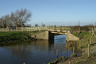
The Glastonbury Canal ran for approximately 14 miles (23 km) through two locks from Glastonbury to Highbridge in Somerset, England, where it entered the River Parrett and from there the Bristol Channel. The canal was authorised by Parliament in 1827 and opened in 1834. It was operated by The Glastonbury Navigation & Canal Company. Most of it was abandoned as a navigation in 1854, when a railway was built along the towpath.

Francis Giles (1787–1847) was a canal engineer and surveyor who worked under John Rennie and later became a railway engineer.

William Cubitt British civil engineer

Sir William Cubitt FRS was an eminent English civil engineer and millwright. Born in Norfolk, England, he was employed in many of the great engineering undertakings of his time. He invented a type of windmill sail and the prison treadwheel, and was employed as chief engineer, at Ransomes of Ipswich, before moving to London. He worked on canals, docks, and railways, including the South Eastern Railway and the Great Northern Railway. He was the chief engineer of Crystal Palace erected at Hyde Park in 1851.

Henry Deane (engineer) Australian botanist

Henry Deane was an Australian engineer, responsible for electrifying the Sydney tramway system and for building the Wolgan Valley Railway and Trans-Australian Railway.

James Meadows Rendel (engineer) British civil engineer

James Meadows Rendel FRS was a British civil engineer.

River Blackwater (Northern Ireland) river in County Armagh and County Tyrone, Northern Ireland and County Monaghan Ireland

The River Blackwater or Ulster Blackwater is a river mainly in County Armagh and County Tyrone, Northern Ireland. It also forms part of the border between the United Kingdom and the Republic of Ireland, flowing between Counties Tyrone and Monaghan, intersecting into County Monaghan briefly. Its source is to the north of Fivemiletown, County Tyrone. The river divides County Armagh from County Tyrone and also divides County Tyrone from County Monaghan.

Westport Canal

The Westport Canal was built in the late 1830s to link Westport and Langport in Somerset, England. It was part of a larger scheme involving improvements to the River Parrett above Burrow Bridge. Langport is the point at which the River Yeo joins the River Parrett and the intention was to enable trade via the port at Bridgwater. It remained in use until the 1870s, but closed when the Somerset Drainage Commissioners took over control of the River Parrett. Despite a petition against closure by local people, the Commissioners ruled that navigation of the canal must cease due to their interpretation of the Act which gave them control of it, leaving the canal to serve as a drainage channel since 1878.

Shannon–Erne Waterway

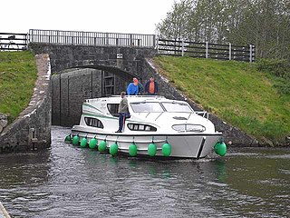
The Shannon–Erne Waterway is a canal linking the River Shannon in the Republic of Ireland with the River Erne in Northern Ireland. Managed by Waterways Ireland, the canal is 63 km (39 mi) in length, has sixteen locks and runs from Leitrim village in County Leitrim to Upper Lough Erne in County Fermanagh.

River Don Navigation waterway navigation in South Yorkshire, England

The River Don Navigation was the result of early efforts to make the River Don in South Yorkshire, England, navigable between Fishlake and Sheffield. The Dutch engineer Cornelius Vermuyden had re-routed the mouth of the river in 1626, to improve drainage, and the new works included provision for navigation, but the scheme did not solve the problem of flooding, and the Dutch River was cut in 1635 to link the new channel to Goole. The first Act of Parliament to improve navigation on the river was obtained in 1726, by a group of Cutlers based in Sheffield; the Corporation of Doncaster obtained an Act in the following year for improvements to the lower river. Locks and lock cuts were built, and, by 1751, the river was navigable to Tinsley.

East Indian Railway Company

The East Indian Railway Company, operating as the East Indian Railway, introduced railways to eastern and northern India, while the Companies such as the Great Indian Peninsular Railway, South Indian Railway, Bombay, Baroda and Central India Railway and the North-Western Railway operated in other parts of India. The company was established 1 June 1845 in London by a deed of settlement with a capital of £4,000,000, largely raised in London.

Campbell W. Adams civil engineer

Campbell W. Adams was an American civil engineer, surveyor and politician from New York. He was New York State Engineer and Surveyor from 1894 to 1898.

Manchester and Bolton Railway

The Manchester and Bolton Railway was a railway in the historic county of Lancashire, England, connecting Salford to Bolton. It was built by the proprietors of the Manchester, Bolton and Bury Canal Navigation and Railway Company who had in 1831 converted from a canal company. The 10-mile (16 km) long railway was originally to have built upon most of the line of the canal, but it was eventually built alongside the Salford and Bolton arms of the canal. The Act of Parliament also allowed the construction of a connection to Bury, but technical constraints meant that it was never built.

John Killaly (1776–1832) was the most significant Irish canal engineer working originally for the Grand Canal company and later, as an engineer, under the Directors-General of Inland Navigation.

William Chapman (engineer) English engineer

William Chapman was an English engineer. Born in Whitby, he worked on the construction of the Old and Humber Docks in Hull, as well as many drainage and canal projects. He is credited with the invention of the bogie and articulation for rail vehicles.

William Snell Chauncy English civil engineer, Australian engineer

William Snell Chauncy was an English civil engineer responsible for a number of important engineering works including the first steam railway opened in Australia.

River Sow Navigation river navigation in Staffordshire, United Kingdom

The River Sow Navigation was a short river navigation in Staffordshire, England, which connected the Staffordshire and Worcestershire Canal to the centre of Stafford. There was a coal wharf in Stafford, and a single lock to connect it to the canal. It opened in 1816, and closed in the 1920s. There are proposals to restore the navigation as the Stafford Riverway Link.

Edward Orpen Moriarty (1825-1896) engineer

Edward Orpen Moriarty (1824-1896) MA MInstCE was an Australian civil engineer, who undertook a number of important public works in New South Wales in the late nineteenth century.

References

  1. 1 2 3 Johnson, Robert. "Bennett, William Christopher (1824–1889)". Australian Dictionary of Biography . Canberra: Australian National University. Retrieved 12 November 2013.
  2. 1 2 3 4 Mennell,Philip (1892)." Wikisource-logo.svg   Bennett, William Christopher".The Dictionary of Australasian Biography.London:Hutchinson & Co. Wikisource